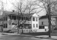
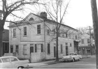
House on site affected by the construction of Interstate 26 (I-26). Address: 91 Fishburne Street. View of Street corner; corner of Fishburne Street and Coming Street. Surveyor notations on back of photo: "Dkt.: 10.517. Property owner: Annie E. Stossen. Tract: 105. Station: 22+65 Lt. Southbound Lane Route 17. Date: March 5, 1963. In R/W - Bought." [See collection description for explanation of surveyor notations.]
House on site affected by the construction of Interstate 26 (I-26). Address: 91 Fishburne Street. Surveyor notations on back of photo: "Dkt.: 10.517. Property owner: Annie E. Stossen. Tract: 105. Station: 22+65 Lt. Southbound Lane Route 17. Date: March 5, 1963. In R/W - Bought." [See collection description for explanation of surveyor notations.]
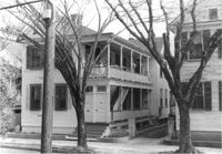
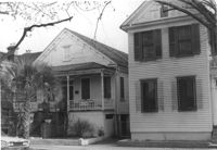
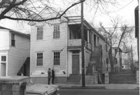
House on site affected by the construction of Interstate 26 (I-26). Address: 87 Fishburne Street (and 87A Fishburne Street). Surveyor notations on back of photo: "Dkt.: 10.517. Property owner: Mona G. Sokol. Tract: 106. Station: 23+00 Lt. Southbound Lane Route 17. Date: March 5, 1963. In R/W - Bought." [See collection description for explanation of surveyor notations.]
House on site affected by the construction of Interstate 26 (I-26). Address: 87 Fishburne Street (and 87A Fishburne Street). Surveyor notations on back of photo: "Dkt.: 10.517. Property owner: Mona G. Sokol. Tract: 106. Station: 23+00 Lt. Southbound Lane Route 17. Date: March 5, 1963. In R/W - Bought." [See collection description for explanation of surveyor notations.]
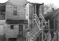
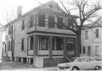
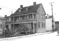
House on site affected by the construction of Interstate 26 (I-26). Address: 85 Fishburne Street and its neighbor, 87 Fishburne Street. Surveyor notations on back of photo: "Dkt.: 10.517. Property owner: Thelma G. Carter. Tract: 107. Station: 23+30 Lt. Southbound Lane Route 17. Date: March 5, 1963. In R/W - Bought." [See collection description for explanation of surveyor notations.]
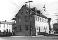
House (corner view) on site affected by the construction of the Crosstown. Address: 57 Lee Street. View of street corner (Lee Street and Hanover Street). Surveyor notations on back of photo: "Dkt.: 10.518. Property owner: Augustus G. Purvis. Tract: 49. Station: 45+05 Lt. N.B. lane Route 17. Date: Mar. 6, 1963. In R/W - Bought." [See collection description for explanation of surveyor notations.]
House on site affected by the construction of Interstate 26 (I-26). Address: 85 Fishburne Street. Surveyor notations on back of photo: "Dkt.: 10.517. Property owner: Thelma G. Carter. Tract: 107. Station: 23+30 Lt. Southbound Lane Route 17. Date: March 5, 1963. In R/W - Bought." [See collection description for explanation of surveyor notations.]
House on site affected by the construction of Interstate 26 (I-26). Address: 83 Fishburne Street. Surveyor notations on back of photo: "Dkt.: 10.517. Property owner: Georgette H. Gilchrist. Tract: 108. Station: 23+75 Lt. Southbound Lane Route 17. Date: March 5, 1963. In R/W - Bought." [See collection description for explanation of surveyor notations.]
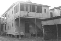
House (rear view) on site affected by the construction of Interstate 26 (I-26). Address: 83 Fishburne Street. Surveyor notations on back of photo: "Dkt.: 10.517. Property owner: Georgette H. Gilchrist. Tract: 108. Station: 23+75 Lt. Southbound Lane Route 17. Date: March 5, 1963. In R/W - Bought." [See collection description for explanation of surveyor notations.]
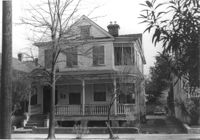
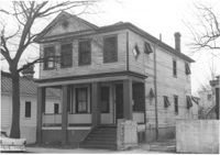
House on site affected by the construction of Interstate 26 (I-26). Address: 79 Fishburne Street. Surveyor notations on back of photo: "Dkt.: 10.517. Property owner: Alma Belle Heath. Tract: 109. Station: 24+05 Lt. Southbound Lane Route 17. Date: March 5, 1963. In R/W - Bought." [See collection description for explanation of surveyor notations.]
House on site affected by the construction of Interstate 26 (I-26). Address: 79 Fishburne Street. Surveyor notations on back of photo: "Dkt.: 10.517. Property owner: Alma Belle Heath. Tract: 109. Station: 24+05 Lt. Southbound Lane Route 17. Date: March 5, 1963. In R/W - Bought." [See collection description for explanation of surveyor notations.]
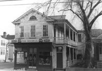
Push Grocery located at the southwest corner of Fishburne and St. Philip Streets, on site affected by the construction of Interstate 26 (I-26). Address: 77 Fishburne Street. Surveyor notations on back of photo: "Dkt.: 10.517. Property owner: Margaret J. Finn. Tract: 110. Station: 24+50 Lt. Southbound Lane Route 17. Date: March 5, 1963. In R/W - Bought." [See collection description for explanation of surveyor notations.]
Push Grocery at the southwest corner of Fishburne and St. Philip Streets (rear corner/southeast elevation), on site affected by the construction of Interstate 26 (I-26). Address: 77 Fishburne Street. View of street corner. Willie's Grill, across the street, in background. Surveyor notations on back of photo: "Dkt.: 10.517. Property owner: Margaret J. Finn. Tract: 110. Station: 24+50 Lt. Southbound Lane Route 17. Date: March 5, 1963. In R/W - Bought." [See collection description for explanation of surveyor notations.]
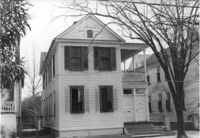
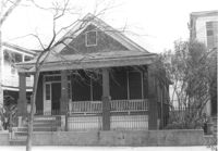
House on site affected by the construction of Interstate 26 (I-26). Address: 289 St. Philip Street. Surveyor notations on back of photo: "Dkt.: 10.517. Property owner: John Henry Mehrtens. Tract: 111. Station: 24+25 Rt. Southbound Lane Route 17. Date: March 5, 1963. In R/W - Bought." [See collection description for explanation of surveyor notations.]
House on site affected by the construction of Interstate 26 (I-26). Address: 289 St. Philip Street. Surveyor notations on back of photo: "Dkt.: 10.517. Property owner: John Henry Mehrtens. Tract: 111. Station: 24+25 Rt. Southbound Lane Route 17. Date: March 5, 1963. In R/W - Bought." [See collection description for explanation of surveyor notations.]
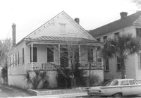
House on site affected by the construction of Interstate 26 (I-26). Address: 268 St. Philip Street. Surveyor notations on back of photo: "Dkt.: 10.517. Property owner: Sara Fox. Tract: 113. Station: 25+20 Rt. Southbound Lane Route 17. Date: March 5, 1963. In R/W - Bought." [See collection description for explanation of surveyor notations.]
House on site affected by the construction of the Crosstown. Address: 57 Lee Street. Surveyor notations on back of photo: "Dkt.: 10.518. Property owner: Augustus G. Purvis. Tract: 49. Station: 45+05 Lt. N.B. lane Route 17. Date: Mar. 6, 1963. In R/W - Bought." [See collection description for explanation of surveyor notations.]
House (corner view, rear) on site affected by the construction of Interstate 26 (I-26). Address: 268 St. Philip Street. Surveyor notations on back of photo: "Dkt.: 10.517. Property owner: Sara Fox. Tract: 113. Station: 25+20 Rt. Southbound Lane Route 17. Date: March 5, 1963. In R/W - Bought." [See collection description for explanation of surveyor notations.]
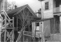
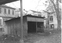
Garage on site affected by the construction of Interstate 26 (I-26). Address: 268 St. Philip Street. Surveyor notations on back of photo: "Dkt.: 10.517. Property owner: Sara Fox. Tract: 113. Station: 26+90 Rt. Southbound Lane Route 17. Date: March 5, 1963. Garage." [See collection description for explanation of surveyor notations.]
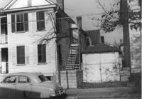
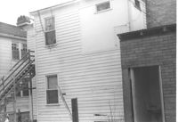
House (rear view) on site affected by the construction of Interstate 26 (I-26). Address: 270 St. Philip Street. Surveyor notations on back of photo: "Dkt.: 10.517. Property owner: William H. Steedley. Tract: 114. Station: 25+40 Rt. Southbound Lane Route 17. Date: March 5, 1963. In R/W - Bought." [See collection description for explanation of surveyor notations.]