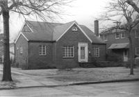
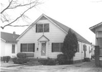
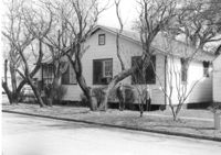
House on site affected by the construction of Interstate 26 (I-26). Address: 169 Laurel Avenue. Surveyor notations on back of photo: "Dkt.: 10.503. Property owner: Ernestine L. Captain. Tract: 5. Station: 5892+10 Rt. Date: Feb. 19, 1963. In R/W - Bought." [See collection description for explanation of surveyor notations.]
House (corner view, rear) on site affected by the construction of Interstate 26 (I-26).Address: 169 Laurel Avenue. Joseph Floyd Manor (Mount Pleasant Street and King Street) in background. Surveyor notations on back of photo: "Dkt.: 10.503. Property owner: Ernestine L. Captain. Tract: 5. Station: 5892+10 Rt. Date: Feb. 19, 1963. In R/W - Bought." [See collection description for explanation of surveyor notations.]
Backyard area and neighboring houses on site affected by the construction of Interstate 26 (I-26). Address: Laurel Avenue (?). Surveyor notations on back of photo: "Dkt.: 10.503. Property owner: Francis D. Guzzell. Tract: 7. Station: 5894+55 Rt. Date: Feb. 19, 1963. Proximity." [See collection description for explanation of surveyor notations.]
House on site affected by the construction of the Crosstown. Address: 76 Cooper Street. Surveyor notations on back of photo: "Dkt.: 10.518. Property owner: Lewis Rosen. Tract: 11. Station: 5965+10 CL Line 3, S.B. lane Route 17. Date: Mar. 6, 1963. In R/W - Bought. [See collection description for explanation of surveyor notations.]
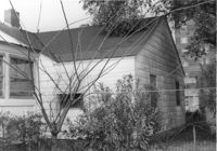
House (rear view) on site affected by the construction of Interstate 26 (I-26). Waverly Novels, Tales of a Grandfather; being stories taken from Scottish history, 2nd series in 2 volumes, vol. I. 160 Laurel Avenue. Surveyor notations on back of photo: "Dkt.: 10.503. Property owner: Joseph A. Pippin. Tract: 8. Station: 5894+40 Rt. Date: Feb. 19, 1963. In R/W - Bought." [See collection description for explanation of surveyor notations.]
House on site affected by the construction of Interstate 26 (I-26). Address: 160 Laurel Avenue. Surveyor notations on back of photo: "Dkt.: 10.503. Property owner: Joseph A. Pippin. Tract: 8. Station: 5894+40 Rt. Date: Feb. 19, 1963. In R/W - Bought." [See collection description for explanation of surveyor notations.]
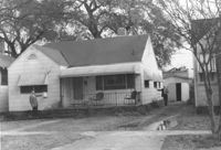
House on site affected by the construction of Interstate 26 (I-26). Address: 162 Laurel Avenue. Number 22 on porch column. Surveyor notations on back of photo: "Dkt.: 10.503. Property owner: David E. O'Brien. Tract: 9. Station: 5894+15 Rt. Date: Feb. 19, 1963. In R/W - Bought." [See collection description for explanation of surveyor notations.]
House (rear view) on site affected by the construction of Interstate 26 (I-26). Address: 162 Laurel Avenue. Surveyor notations on back of photo: "Dkt.: 10.503. Property owner: David E. O'Brien. Tract: 9. Station: 5894+15 Rt. Date: Feb. 19, 1963. In R/W - Bought." [See collection description for explanation of surveyor notations.]
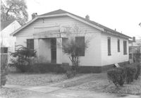
House (rear view) on site affected by the construction of Interstate 26 (I-26). Address: 164 Laurel Avenue. Surveyor notations on back of photo: "Dkt.: 10.503. Property owner: J.W. Johnson, Jr. Tract: 10. Station: 5894+00 Rt. Date: Feb. 19, 1963. In R/W - Bought." [See collection description for explanation of surveyor notations.]
House on site affected by the construction of Interstate 26 (I-26). Address: 164 Laurel Avenue. Surveyor notations on back of photo: "Dkt.: 10.503. Property owner: J.W. Johnson, Jr. Tract: 10. Station: 5894+00 Rt. Date: Feb. 19, 1963. In R/W - Bought." [See collection description for explanation of surveyor notations.]
House on site affected by the construction of Interstate 26 (I-26). Address: 166-168 Laurel Avenue. Surveyor notations on back of photo: "Dkt.: 10.503. Property owner: J.W. Johnson, Jr. Tract: 10. Station: 5894+00 Rt. Date: Feb. 19, 1963. In R/W - Bought." [See collection description for explanation of surveyor notations.]
House (rear view) on site affected by the construction of Interstate 26 (I-26). Address: 166-168 Laurel Avenue. Surveyor notations on back of photo: "Dkt.: 10.503. Property owner: J.W. Johnson, Jr. Tract: 10. Station: 5894+00 Rt. Date: Feb. 19, 1963. In R/W - Bought." [See collection description for explanation of surveyor notations.]
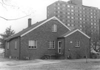
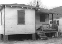
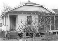
House (rear view) on site affected by the construction of Interstate 26 (I-26). Address: 170 Laurel Avenue. Surveyor notations on back of photo: "Dkt.: 10.503. Property owner: Eula Mae Ryan. Tract: 12. Station: 5893+40 Lt. Date: Feb. 19, 1963. In R/W - Bought." [See collection description for explanation of surveyor notations.]
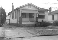
House on site affected by the construction of Interstate 26 (I-26). Address: 170 Laurel Avenue. Number 28 on porch column. Surveyor notations on back of photo: "Dkt.: 10.503. Property owner: Eula Mae Ryan. Tract: 12. Station: 5893+40 Lt. Date: Feb. 19, 1963. In R/W - Bought." [See collection description for explanation of surveyor notations.]
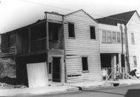
Houses on site affected by the construction of the Crosstown. Address: 74½ Cooper Street [74 Cooper Street]. Surveyor notations on back of photo: "Dkt.: 10.518. Property owner: Beatrice Hayward. Tract: 12. Station: 5965+30 Rt. Line 3, S.B. lane of Route 17. Date: Mar. 6, 1963. In R/W - Bought. [See collection description for explanation of surveyor notations.]
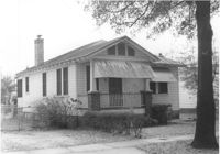
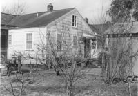
House on site affected by the construction of Interstate 26 (I-26).Address: 172 Laurel Avenue. Surveyor notations on back of photo: "Dkt.: 10.503. Property owner: Marguerite E. Jacques. Tract: 13. Station: 5893+20 Lt. Date: Feb. 19, 1963. In R/W - Bought." [See collection description for explanation of surveyor notations.]
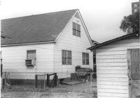
House (rear view) on site affected by the construction of Interstate 26 (I-26). Address: 172 Laurel Avenue. Surveyor notations on back of photo: "Dkt.: 10.503. Property owner: Marguerite E. Jacques. Tract: 13. Station: 5893+20 Lt. Date: Feb. 19, 1963. In R/W - Bought." [See collection description for explanation of surveyor notations.]
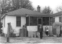
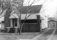
House (side view) on site affected by the construction of Interstate 26 (I-26). Address: 29 Mount Pleasant Street. Joseph Floyd Manor (Mount Pleasant Street and King Street) faintly in background. On corner of on Mount Pleasant Street and King Street. Surveyor notations on back of photo: "Dkt.: 10.503. Property owner: Charles B. Cromer, et al. Tract: 14. Station: 5892+90 Lt. Date: Feb. 19, 1963. In R/W - Bought." [See collection description for explanation of surveyor notations.]
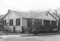
House on site affected by the construction of Interstate 26 (I-26). Address: 29 Mount Pleasant Street. Surveyor notations on back of photo: "Dkt.: 10.503. Property owner: Charles B. Cromer, et al. Tract: 14. Station: 5892+90 Lt. Date: Feb. 19, 1963. In R/W - Bought." [See collection description for explanation of surveyor notations.]
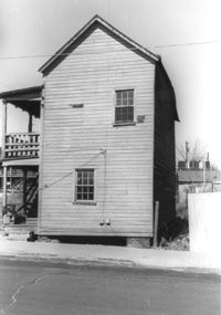
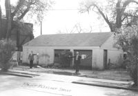
Garage building on site affected by the construction of Interstate 26 (I-26). Address: 29 Mount Pleasant Street. Surveyor notations on back of photo: "Dkt.: 10.503. Property owner: Charles B. Cromer, et al. Tract: 14. Station: 5893+35 Lt. Date: Feb. 19, 1963. Bought." [See collection description for explanation of surveyor notations.]