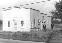
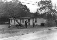
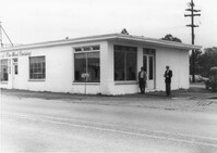
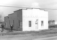
Building, on site affected by the widening of Route 171 (Folly Road). Dave Richardson and Son General Contractor. Front facade has stepped parapet. Surveyor notations on back of photo: "Dkt.: 10.494. Property owner: Dave Richardson, et al. Tract: 93. Station: 314+40 Lt. Date: Mar. 21, 1962. To be cut off at R/W by SCHD [SC Highway Department?]. [See collection description for explanation of surveyor notations.]
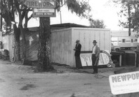
Half Moon Cafe on site affected by the construction of Interstate 26 (I-26). Front facade has stepped parapet. Building address number 1995. Surveyor notations on back of photo: "Dkt.: 10.490. Property owner: Illa G. Feldman. Tract: 35. Station: 5796+30 Rt. and Lt. Line 'A'. Date: September 11, 1962. In R/W - Bought." [See collection description for explanation of surveyor notations.]
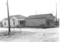
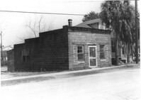
Joe Smith's Grocery, at the corner of Doscher Avenue and Farwell Street, on site affected by the construction of Interstate 26 (I-26). [Building address number 1934.] House to its rear also in photo. Surveyor notations on back of photo: "Dkt.: 10.490. Property owner: Joseph F. Smith. Tract: 21. Station: 5819+00 Rt. Line "G." Date: March 22, 1962. In R/W - Bought." [See collection description for explanation of surveyor notations.]
Joe Smith's Grocery [at the corner of Doscher Avenue and Farwell Street] on site affected by the construction of Interstate 26 (I-26). Building address number 1934. Surveyor notations on back of photo: "Dkt.: 10.490. Property owner: Joseph F. Smith. Tract: 21. Station: 5819+00 Rt. Line "G." Date: March 22, 1962. In R/W - Bought." [See collection description for explanation of surveyor notations.]
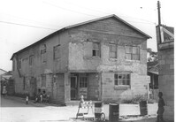
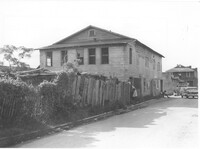
Building on site affected by the construction of Interstate 26 (I-26). View of street corner. Appears to previously have been a corner store named "Upper 10," perhaps with residence on second floor. Surveyor notations on back of photo: "Dkt.: 10.490. Property owner: Robert Martin. Tract: 38. Station: 5957+45 on CL Line 'G'. Date: September 11, 1962. In R/W - Bought." [See collection description for explanation of surveyor notations.]
Renken Boat Co, on site affected by the widening of Route 171 (Folly Road). Surveyor notations on back of photo: "Dkt.: 10.494. Property owner: Renken Finance Co. Tract: 19. Station: 157+00 Lt. Date: Mar. 21, 1962. Proximity. [See collection description for explanation of surveyor notations.]
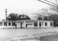
Furniture Repair Shop, on site affected by the widening of Route 171 (Folly Road). Surveyor notations on back of photo: "Dkt.: 10.494. Property owner: Isadora Bischoff. Tract: 32. Station: 162+00 Lt. Date: Mar. 21, 1962. Owner to cut off at R/W. [See collection description for explanation of surveyor notations.]
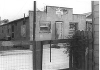
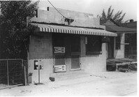
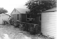
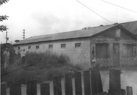
Building (rear view), perhaps once used commercially (market?), on site affected by the construction of Interstate 26 (I-26). Side facade has stepped parapet. [Building address number 2212(?).] Surveyor notations on back of photo: "Dkt.: 10.490. Property owner: F.F. Bellinger. Tract: 88. Station: 5825+40 Rt. Date: March 22, 1962. In R/W - Bought." [See collection description for explanation of surveyor notations.]
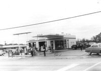
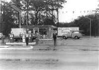
J&K Minute Market [893 Folly Road] and Sinclair gas station, on site affected by the widening of Route 171 (Folly Road). Surveyor notations on back of photo: "Dkt.: 10.494. Property owner: Otis R. Burbage. Tract: 40. Station: 176+40 Rt. Date: Mar. 21, 1962. Proximity. [See collection description for explanation of surveyor notations.]
Building on site affected by the construction of Interstate 26 (I-26). Appears to previously have been a market; signage for Tru Ade (Drink) in window; gumball machines in front on sidewalk. Front facade has stepped parapet. Surveyor notations on back of photo: "Dkt.: 10.490. Property owner: Loretta Gillard [Loretta Gaillard]. Tract: 56. 5801+55 Lt. Line 'F'. Date: September 12, 1962. In R/W - Bought." [See collection description for explanation of surveyor notations.]
H.W. Halter Cheese Butter Oleo Poultry Eggs [company], on site affected by the widening of Route 171 (Folly Road). Surveyor notations on back of photo: "Dkt.: 10.494. Property owner: H.W. Halter, et al. Tract: 78. Station: 209+20 Rt. Date: Mar. 21, 1962. Proximity. Loss of parking space. [See collection description for explanation of surveyor notations.]
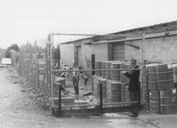
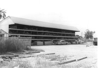
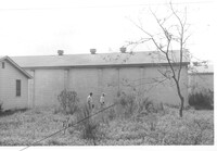
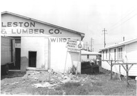
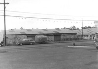
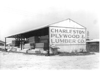
Charleston Plywood & Lumber Co. building (side view) on site affected by the construction of Interstate 26 (I-26). Surveyor notations on back of photo: "Dkt.: 10.490. Property owner: Kurco, Inc. Tract: 120, 121, 124 through 140-A and 133 through 133. Station: 5831+35 Rt. Date: August 29, 1962. Part in R/W to be moved by SCHD {SC Highway Department]." [See collection description for explanation of surveyor notations.]
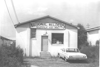
National Welders Supply Co. Inc. building, on site affected by the construction of Interstate 26 (I-26). Building address number 1858. Surveyor notations on back of photo: "Dkt.: 10.490. Property owner: Minnie R. Sherman. Tract: 115 and 118. Station: 5829+80 Lt. Date: August 29, 1962." [See collection description for explanation of surveyor notations.]
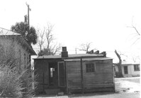
Sheds on site affected by the construction of Interstate 26 (I-26). Address: 1334 Rutledge Avenue. Surveyor notations on back of photo: "Dkt.: 10.490. Property owner: Heyward Barnes. Tract: 168. Station: 85' Rt. Sta. 5882+90. Date: May 15, 1962. In R/W - Bought." [See collection description for explanation of surveyor notations.]
Charleston Plywood & Lumber Co. building (side view) on site affected by the construction of Interstate 26 (I-26). Surveyor notations on back of photo: "Dkt.: 10.490. Property owner: Kurco, Inc. Tract: 120, 121, 124 through 140-A and 133 through 133. Station: 5832+30 Rt. Date: August 29, 1962." [See collection description for explanation of surveyor notations.]
Charleston Plywood and Lumber Co. building (side view) on site affected by the construction of Interstate 26 (I-26). Surveyor notations on back of photo: "Dkt.: 10.490. Property owner: Minnie R. Sherman. Tract: 104-B. Station: 5829+20 Lt. Date: August 29, 1962. End to be moved by SCHD [SC Highway Department]." [See collection description for explanation of surveyor notations.]
Charleston Plywood and Lumber Co. building, on site affected by the construction of Interstate 26 (I-26). Surveyor notations on back of photo: "Dkt.: 10.490. Property owner: Minnie R. Sherman. Tract: 104-B. Station: 5829+20 Lt. Date: August 29, 1962. End to be moved by SCHD [SC Highway Department]." [See collection description for explanation of surveyor notations.]
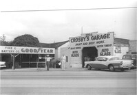
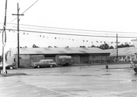
Crosby Tire & Battery Co. and Crosby's Garage, on site affected by the construction of Interstate 26 (I-26). Address 2204 and 2206 [Meeting Street Road]. Surveyor notations on back of photo: "Dkt.: 10.490. Property owner: M. Crosby. Tract: 66. Station: 5803+40 Lt. Line 'F'. Date: September 12, 1962. Proximity." [See collection description for explanation of surveyor notations.]
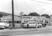
Crosby Tire & Battery Co., on site affected by the construction of Interstate 26 (I-26). [Address 2204 or 2206 Meeting Street Road.] Surveyor notations on back of photo: "Dkt.: 10.490. Property owner: M. Crosby. Tract: 66. Station: 5803+30 Lt. Line 'F'. Date: September 12, 1962. To be cut at R/W." [See collection description for explanation of surveyor notations.]
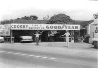
Crosby Tire & Battery Co., on site affected by the construction of Interstate 26 (I-26). [Address 2204 or 2206 Meeting Street Road.] Surveyor notations on back of photo: "Dkt.: 10.490. Property owner: M. Crosby. Tract: 66. Station: 5803+30 Lt. Line 'F'. Date: September 12, 1962. To be cut at R/W." [See collection description for explanation of surveyor notations.]
Building on site affected by the widening of Route 171 (Folly Road). (May be apartments or a motel.) Surveyor notations on back of photo: "Dkt.: 10.494. Property owner: James E. Smoot, et al. Tract: 34. Station: 170+80 Rt. Date: Mar. 21, 1962. Proximity. [See collection description for explanation of surveyor notations.]
Building on site affected by the widening of Route 171 (Folly Road). (May be apartments or a motel.) Surveyor notations on back of photo: "Dkt.: 10.494. Property owner: James E. Smoot, et al. Tract: 34. Station: 170+80 Rt. Date: Mar. 21, 1962. Proximity. [See collection description for explanation of surveyor notations.]
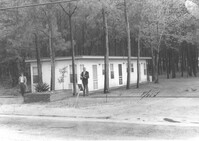
Building on site affected by the construction of Interstate 26 (I-26). On corner of Meeting Street and ? View of street corner. Surveyor notations on back of photo: "Dkt.: 10.510. Property owner: Ada M. Crosby Life Est. Tract: 66-C. Station: 5810+60 Lt. Line B (Meeting Street). Date: Sept. 12, 1962. Proximity." [See collection description for explanation of surveyor notations.]
Building, perhaps once used commercially (market?), on site affected by the construction of Interstate 26 (I-26). Building address number 2212(?). Side facade has stepped parapet. Surveyor notations on back of photo: "Dkt.: 10.490. Property owner: F.F. Bellinger. Tract: 88. Station: 5825+40 Rt. Date: March 22, 1962. In R/W - Bought." [See collection description for explanation of surveyor notations.]
Gulf gas station, on site affected by the widening of Route 171 (Folly Road). Surveyor notations on back of photo: "Dkt.: 10.494. Property owner: Tremarco Corp. Tract: 46. Station: 178+90 Rt. Date: Mar. 21, 1962. Owner to move pumps. [See collection description for explanation of surveyor notations.]
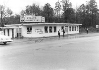
Feran's Superette No. 1, on site affected by the widening of Route 171 (Folly Road). Surveyor notations on back of photo: "Dkt.: 10.494. Property owner: Hula S. Feran. Tract: 55. Station: 178+60 Lt. Date: Mar. 21, 1962. Proximity. [See collection description for explanation of surveyor notations.]
Renken Boat Co, on site affected by the widening of Route 171 (Folly Road). Surveyor notations on back of photo: "Dkt.: 10.494. Property owner: Renken Finance Co. Tract: 19. Station: 157+00 Lt. Date: Mar. 21, 1962. Proximity. [See collection description for explanation of surveyor notations.]
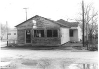
Building and lot on site affected by the construction of Interstate 26 (I-26). Building appears to previously have been a corner store. Signage for Coca Cola, Dr. Pepper, and Ballentine Ale. Building address number 2015. Surveyor notations on back of photo: "Dkt.: 10.490. Property owner: Nathaniel Phoenix. Tract: 45. Station: 5799+40 Rt. Line 'G'. Date: September 11, 1962. In R/W - Bought." [See collection description for explanation of surveyor notations.]
Furniture Repair Shop, on site affected by the widening of Route 171 (Folly Road). Surveyor notations on back of photo: "Dkt.: 10.494. Property owner: Isadora Bischoff. Tract: 32. Station: 162+00 Lt. Date: Mar. 21, 1962. Owner to cut off at R/W. [See collection description for explanation of surveyor notations.]
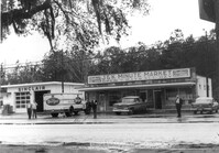
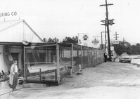
McFadden Open Air Market, on site affected by the widening of Route 171 (Folly Road). Surveyor notations on back of photo: "Dkt.: 10.494. Property owner: Margaret H. Heirs. Tract: 44. Station: 175+50 Lt. Date: Mar. 21, 1962. Proximity. [See collection description for explanation of surveyor notations.]
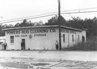
Powers Rug Cleaning Co, on site affected by the widening of Route 171 (Folly Road). Surveyor notations on back of photo: "Dkt.: 10.494. Property owner: K. & Dorothy Ohlinge. Tract: 38. Station: 174+30 Rt. Date: Mar. 21, 1962. Proximity. [See collection description for explanation of surveyor notations.]
Renken Boat Co, on site affected by the widening of Route 171 (Folly Road). Surveyor notations on back of photo: "Dkt.: 10.494. Property owner: Renken Finance Co. Tract: 19. Station: 157+00 Lt. Date: Mar. 21, 1962. Proximity. [See collection description for explanation of surveyor notations.]
Renken Boat Co, on site affected by the widening of Route 171 (Folly Road). Surveyor notations on back of photo: "Dkt.: 10.494. Property owner: Renken Finance Co. Tract: 19. Station: 157+00 Lt. Date: Mar. 21, 1962. Proximity. [See collection description for explanation of surveyor notations.]
Building, on site affected by the widening of Route 171 (Folly Road). Dave Richardson and Son General Contractor. Front facade has stepped parapet. Surveyor notations on back of photo: "Dkt.: 10.494. Property owner: Dave Richardson, et al. Tract: 93. Station: 314+40 Lt. Date: Mar. 21, 1962. To be cut off at R/W by SCHD [SC Highway Department?]. [See collection description for explanation of surveyor notations.]
Spar gas station, on site affected by the widening of Route 171 (Folly Road). Surveyor notations on back of photo: "Dkt.: 10.494. Property owner: Palm Oil Co. Tract: 45. Station: 176+80 Lt. Date: Mar. 21, 1962. Owner to move pumps. [See collection description for explanation of surveyor notations.]
Renken Boat Co, on site affected by the widening of Route 171 (Folly Road). Surveyor notations on back of photo: "Dkt.: 10.494. Property owner: Renken Finance Co. Tract: 19. Station: 157+00 Lt. Date: Mar. 21, 1962. Proximity. [See collection description for explanation of surveyor notations.]
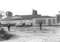
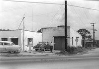
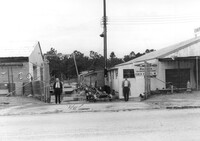
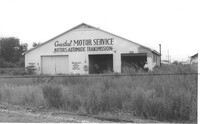
Coastal Motor Service, on site affected by the construction of Interstate 26 (I-26). Surveyor notations on back of photo: "Dkt.: 10.490. Property owner: Ashley River Realty Co. Tract: 141. Station: 5872+00 Lt. Date: August 29, 1962. Proximity." [See collection description for explanation of surveyor notations.]
Charleston Plywood & Lumber Co. building on site affected by the construction of Interstate 26 (I-26). Surveyor notations on back of photo: "Dkt.: 10.490. Property owner: Kurco, Inc. Tract: 120, 121, 124 through 140-A and 133 through 133. Station: 5832+30 Rt. Date: August 29, 1962. Part in R/W to be moved by SCHD {SC Highway Department]." [See collection description for explanation of surveyor notations.]
Building (rear view) on site affected by the construction of Interstate 26 (I-26). [Possibly previously a corner store with residence on second floor.] Surveyor notations on back of photo: "Dkt.: 10.490. Property owner: Robert Martin. Tract: 38. Station: 5957+45 on CL Line 'G'. Date: September 11, 1962. In R/W - Bought." [See collection description for explanation of surveyor notations.]