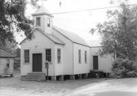
Enah Chapel Church on site affected by the construction of Interstate 26 (I-26). Surveyor notations on back of photo: "Dkt.: 10.480. Property owner: Enoch Methodist Church. Tract: 36. Station: 5507+80 Lt. Date: May 2, 1961. In R/W - Bought." [See collection description for explanation of surveyor notations.]
House on site affected by the construction of Interstate 26 (I-26). Surveyor notations on back of photo: "Dkt.: 10.480. Property owner: Joseph Perry. Tract: 34. Station: 5507+10 Lt. Date: May 2, 1961. In R/W - Bought." [See collection description for explanation of surveyor notations.]
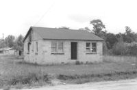
House on site affected by the construction of Interstate 26 (I-26). Building address number 105. Surveyor notations on back of photo: "Dkt.: 10.480. Property owner: Norman Lubesky. Tract: 284. Station: 5733+50 Lt. (Line B). Date: May 30, 1961. In R/W - Bought." [See collection description for explanation of surveyor notations.]
House, possibly duplex, on site affected by the construction of Interstate 26 (I-26). Surveyor notations on back of photo: "Dkt.: 10.480. Property owner: Roy A. Farley, et al. Tract: 102-A. Station: 55+60 Lt. (Goodrich Road). Date: May 2, 1961. Proximity." [See collection description for explanation of surveyor notations.]
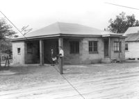
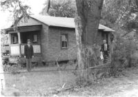
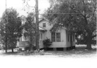
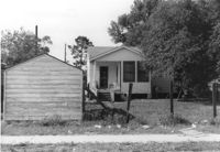
House on site affected by the construction of Interstate 26 (I-26). Outbuilding in background. Surveyor notations on back of photo: "Dkt.: 10.480. Property owner: Rosa Bell Harley. Tract: 83. Station: 5521+80 Rt. Date: May 2, 1961. In R/W - Bought." [See collection description for explanation of surveyor notations.]
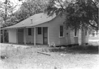
House on site affected by the construction of Interstate 26 (I-26). Surveyor notations on back of photo: "Dkt.: 10.480. Property owner: Joe Stephens, Est. Tract: 29. Station: 5506+00 Lt. Date: May 1, 1961. In R/W - Bought." [See collection description for explanation of surveyor notations.]
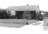
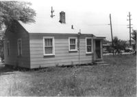
House on site affected by the construction of Interstate 26 (I-26). Surveyor notations on back of photo: "Dkt.: 10.480. Property owner: Evelyn Nelson. Tract: 80. Station: 5519+30 Rt. Date: May 2, 1961. In R/W - Bought." [See collection description for explanation of surveyor notations.]
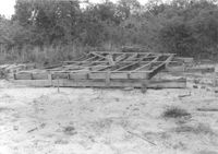
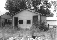
Pile of wood framing on lot, on site affected by the construction of Interstate 26 (I-26). Surveyor notations on back of photo: "Dkt.: 10.480. Property owner: Williams Furniture Co., et al. Tract: 103-B. Station: 5583+55 Rt. Date: May 2, 1961. In R/W - Bought." [See collection description for explanation of surveyor notations.]
House (rear view?) and structure (garage or shed) on site affected by the construction of Interstate 26 (I-26). Building address number 1800. Possibly on Rivers Avenue. Surveyor notations on back of photo: "Dkt.: 10.486. Property owner: G.P. Parris, Est. Tract: 6. Station: 9+50 Lt. Date: May 30, 1961. In R/W - Bought." [See collection description for explanation of surveyor notations.]
House (corner view, rear) on site affected by the construction of Interstate 26 (I-26). Building address number 1806. Possibly on Rivers Avenue. Surveyor notations on back of photo: "Dkt.: 10.486. Property owner: Cleve G. Murray. Tract: 12. Station: 10+90 Lt. Date: May 30, 1961. In R/W - Bought." [See collection description for explanation of surveyor notations.]
House on site affected by the construction of Interstate 26 (I-26). Piggly Wiggly store across the street, in background. Possibly on Rivers Avenue. Surveyor notations on back of photo: "Dkt.: 10.486. Property owner: Mrs. Hazel Faulkner. Tract: 9. Station: 10+35 Lt. Date: May 30, 1961. In R/W - Bought." [See collection description for explanation of surveyor notations.]
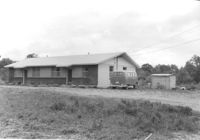
House on site affected by the construction of Interstate 26 (I-26). Surveyor notations on back of photo: "Dkt.: 10.480. Property owner: Herbert Jones. Tract: 192. Station: 5687+00 Lt. Date: May 31, 1961. In R/W - Bought." [See collection description for explanation of surveyor notations.]
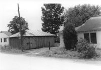
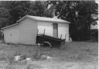
Structure (storage shed/garage) on site affected by the construction of Interstate 26 (I-26). Possibly on Rivers Avenue. Surveyor notations on back of photo: "Dkt.: 10.486. Property owner: Otis R. Burbage. Tract: 22 & 34. Station: 14+80 Rt. Date: May 30, 1961. In R/W to be moved." [See collection description for explanation of surveyor notations.]
Outbuilding on site affected by the construction of Interstate 26 (I-26). Possibly on Rivers Avenue. Surveyor notations on back of photo: "Dkt.: 10.486. Property owner: Redding F. Moore. Tract: 23, 24, 25. Station: 15+90 Rt. (Line C). Date: May 30, 1961. In R/W - Bought." [See collection description for explanation of surveyor notations.]
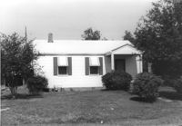
House on site affected by the construction of Interstate 26 (I-26). Possibly on Rivers Avenue. Surveyor notations on back of photo: "Dkt.: 10.486. Property owner: Edward R. Livingston. Tract: 17. Station: 12+25 Lt. Date: May 30, 1961. In R/W - Bought." [See collection description for explanation of surveyor notations.]
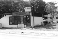
DuMont Television / Patterson's TV & Appliance Service Center / Karts Sales & Service on Dorchester Road, on site affected by the construction of Interstate 26 (I-26). Surveyor notations on back of photo: "Dkt.: 10.480. Property owner: Mrs. Margaret H. Patterson. Tract: 181. Station: 134+15 (Rt. (Route 642) [Dorchester Road]. Date: May 31, 1961. In R/W - Bought." [See collection description for explanation of surveyor notations.]
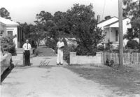
Driveway with low block walls on either side, on site affected by the construction of Interstate 26 (I-26). Two neighboring houses on either side in view. Surveyor notations on back of photo: "Dkt.: 10.480. Property owner: Mrs. Elena B. Pye. Tract: 186. Station: 5685+00 Rt. (Line D). Date: May 31, 1961. Block wall to be moved by SCHD." [See collection description for explanation of surveyor notations.]
House and shed (rear view) on Dorchester Road, on site affected by the construction of Interstate 26 (I-26). Building address number 9. Surveyor notations on back of photo: "Dkt.: 10.480. Property owner: John H. Schulken, Est. Tract: 180. Station: 133+30 Rt. (Route 642) [Dorchester Road]. Date: May 31, 1961. In R/W - Bought." [See collection description for explanation of surveyor notations.]
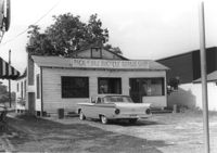
Pick & Pay Bicycle Repair Shop on site affected by the construction of Interstate 26 (I-26). Surveyor notations on back of photo: "Dkt.: 10.480. Property owner: G.S. Carter, Sr. Tract: 166. Station: 5681+50 Lt. Date: May 30, 1961. In R/W - Bought." [See collection description for explanation of surveyor notations.]
House (rear view) on site affected by the construction of Interstate 26 (I-26). Surveyor notations on back of photo: "Dkt.: 10.480. Property owner: Charlie C. Caldwell. Tract: 195. Station: 5688+50 Rt. Date: May 31, 1961. In R/W - Bought." [See collection description for explanation of surveyor notations.]