Photograph of wooden building demolished by the first tornado of September 29, 1938. The photograph is marked with a small green X to show the location of the body of a man killed by the tornado. Handwritten on back of photo: "1st tornado came in by Battery near Miller's junk yard - Laurence [Laurens?] Street. This shed is on top of small Negro house. The Negro was dead when found. Sept. 29, '38."
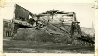
Photograph of the Viohl Hay & Grain warehouse demolished by the tornado of September 29, 1938. Located at the northwest corner of Vendue Range and Concord Street (address 14 Vendue Range). Portion of the building across the street can be seen at left. Steeple of St. Michael's Church in the distance at right. Handwritten on back of photo: "Taken in front of the Clyde Line Steam Ship Co. on Concord Street. Vohls Grain Place. Tornado - Sept. 29, 1938. In distance is St. Michael's Church steeple."
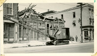
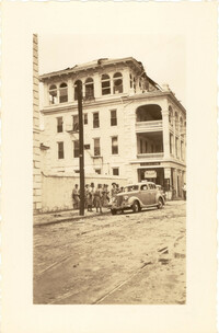
Photograph of the I.M. Pearlstine Building (203 East Bay Street), located on the southwest corner of East Bay Street and Street, after the tornado of September 29, 1938, showing the damage done to the building. Also shows 205 East Bay Street, located on the northwest corner of East Bay and Cumberland. "Bay City" heavy equipment vehicle (excavator?) parked in front of building. Pedestrian and a street worker walking on the sidewalk; repairman on the utility pole on the street corner.
Photograph showing several dwellings in Fiddlers Green damaged or destroyed by the tornado of 1938. Handwritten on back of photo: "1st tornado hit Fiddlers Green, Negro section by Ashley Bridge, Hilly Street [should be Lilly Street], Sept. 29, '38."
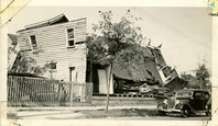
Photograph of a house on Fishburne Street demolished by the tornado of 1938. Neighboring house in view at left. (Both houses would have been on the north side of the 200 block of Fishburne Street.) Handwritten on back of photo: "2nd tornado on Fishburne Street near President Street. Demolished about 60 houses here. This 2nd tornado damage about $6,000,000. 300 houses condemned. Sept. 29, '38."
Photograph of the wreckage of the Calvary Baptist Church, an African-American church demolished by the tornado of September 29, 1938. Located at the corner of Sumter Street and Ashley Avenue; address may have been 387 Sumter Street. Handwritten on back of photo: "Old Negro church on Sumter Street, corner of Ashley Avenue. This was done by second tornado that hit 2 miles from the other one. Sept. 29, 1938."
Photograph of the ruins of a building on King Street after the tornadoes of September 29, 1938. Shows the debris of a completely demolished structure and the damaged roof of the neighboring building. Based on newspaper accounts, this is probably the site of the Rectory of the Church of the Sacred Heart at King and Huger Streets. Three men stand on the sidewalk facing the debris; other men are standing on a pile of debris.
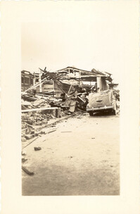
Looking east on Market Street after the tornadoes of September 29, 1938, showing the Market Sheds in ruins. A damaged car is parked along side of the debris. The Old Church of the Redeemer can be seen in the background.
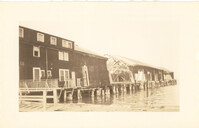
Photograph of the United Fruit Company dock after the September 29, 1938, tornadoes. (Based on Sanborn Maps, the dock was located at the foot of Laurens Street, Southern Railway Pier 2.)
Photograph of the Timrod Hotel [ca. 101 Meeting Street], after the tornadoes of September 29, 1938, showing the damage done to the building. View of the hotel looking north on Meeting Street (southeast elevation). Infantry patrolmen stand on sidewalk by a car. Signage for Byars Drug Store is on the south elevation. [Note: The hotel was later demolished in the 1960s.]