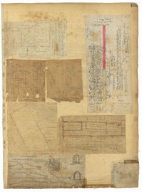
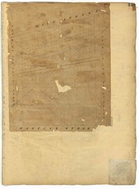
Page 105 of the City Engineer's Plat Book with seven plats. Plat 1 shows several lots located on Chalmers Street. Plat 2 shows lots located near the intersection of East Bay Street and Market Street, and several structures, including docs and wharves. Plat 3 features lots and structures located on Chalmers Street. Plat 4 features a lot located on the intersection of Church Street and Waters Street, and shows several structures. Plat 5 shows a lot and several structures located on Waters Street. Plat 6 features a lot and buildings located on Broad Street. Plat 7 features the profiles of streets where tidal drains will be built. The profiles include Calhoun Street, Mazyck Street, Logan Street, Tradd Street, Coming Street, Chesnut Street, Spring Street, and Meeting Street.
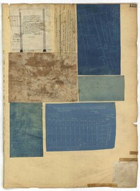
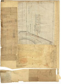
Page 125 of the City Engineer's Plat Book with seven plats. Plat 1 shows several measurements for a structure. Plat 2 shows the line of division between St. Mary's Church Yard and the "Property of Mrs. Anna D. Fleming." Plat 3 shows two wharves. Plat 4 shows lots and structures near wharf street. Plat 5 shows lots near the intersection of Washington Street and Laurens Street. Plat 6 shows lots between Rose Lane and Market Street, near where they intersect with East Bay Street. Plat 7 shows lots between Congress Street and Race Street, near Rutledge Street.
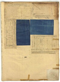
Page 137 of the City Engineer's Plat Book with six plats. Plat 1 shows lots located on and near Mazyck Street, between Short Street and King Street. Plat 2 shows lots located on and near the intersection of Pitt Street and Montague Street. Plat 3 features a lot located on the intersection of Archdale Street and Berresford Street. Plat 4 features a lot located at the intersection of Queen Street and Meeting Street. Plat 5 shows a lot located at the intersection of Queen Street and King Street. Plat 6 shows lots located on and near the intersection of Mazyck Street and Magazine Street, including one labelled "Roper Hospital Lot."
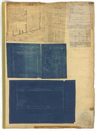
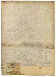
Page 145 of the City Engineer's Plat Book with seven plats. Plat 1 shows lots located on Chapel Street, near where they intersect with Alexander Street. Plat 2 shows lots and structures located on South Street, near where it intersects with another street. Plat 3 shows lots located along Anson Street, near where it intersects with Calhoun Street. Plat 4 features lots located on the "Eastern end of Wraggs" Street. Plat 4 shows lots and structures located between Concord Street and Wharf Street, near where they intersect with Inspection Street. Plat 5 features a strip of land belonging to the Charleston Gas Light Company, located near Concord Street. It also shows a "Train-way" and a building labelled "Gas Works." Plat 7 shows lots and structures located between Line Street and Sheppard Street.
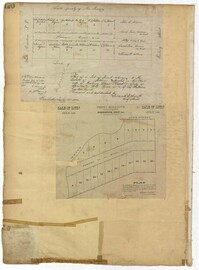
Page 149 of the City Engineer's Plat Book with one plat. The plat shows lots located between Meeting Street and King Street, including a stretch of railroad.
Page 158 of the City Engineer's Plat Book with four plats. Plat 1 shows lots located on South Street, near where it intersects with Hanover Street. Plat 2 shows lots located on and near Mill Street, near its intersections with Lucas Street and President Street, and shows a building labelled "Dead House" and a creek labeled as "leading to canal." Plat 3 shows lots and structures located on East Bay Street. Plat 4 shows South Bay Street and its intersections with Legare Street and King Street.
Page 190 of the City Engineer's Plat Book with two plats. Plat 1 shows lots located along Addison's Court, between Meeting Street and a lot owned by the South Carolina Rail Road. Plat 2 shows lots along Kennedy Street, near Line Street and a stretch of Marsh.
Page 170 of the City Engineer's Plat Book with four plats. Plat 1 shows lots located between King Street and Meeting Street, and between Romney Street and Grove Street. Plat 2 shows lots located between King Street and Meeting Street, and between Brigade Street and Mount Pleasant Street. Plat 4 shows lots located on Butler Street, near its intersection with Russell Street. Plat 5 features a lot labelled "Reservoir," located between Hanover Street and America Street.