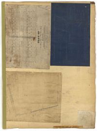
Page 204 of the City Engineer's Plat Book with one plat. The plat shows lots and structures located near the intersection of Meeting Street and Broad Street.
Page 194 of the City Engineer's Plat Book with three plats. Plat 1 shows lots located near the intersection of Line Street and Comming Street. Plat 2 shows lots and structures located near Chesnut Street. Plat 3 shows lots and structures located on and near Calhoun Street, between Meeting Street and Anson Street.
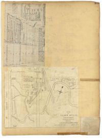
Page 179 of the City Engineer's Plat Book with two plats. Plat 1 shows lots located on and near Hinloch Court and Meeting Street. Plat 2 shows lots located between Moultrie Street and Price Street.
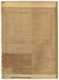
Page 173 of the City Engineer's Plat Book with five plats. Plat 1 shows lots and structures located near the intersection of Meeting Street and Brigade Street. Plat 2 shows lots located between Meeting Street and Lee Street, and includes a lot labeled "German Cemetery." Plat 3 shows lots located between Cunnington Avenue and Wiliman Street, and between Meeting Street and Lee Street, and shows a lot labeled "4th Brigade." Plat 4 shows lots located near Brigade Street. Plat 5 features lots located in the Village of Hampstead, between Bay Street and Town Creek.
Page 177 of the City Engineer's Plat Book with two plats. Plat 1 shows lots located between Meeting Street and King Street, near Russell Street, "Rumney" Street, and Poinsett Street. Plat 2 shows lots, structures, and streams located near Hanover Street, America Street, and Payne Street.
Page 169 of the City Engineer's Plat Book with three plats. Plat 1 shows lots and structures on and near Dehon Street, between King Street and Meeting Street. Plat 2 shows lots located between King Street and Meeting Street, south of Romney Street. Plat 3 shows lots and structures located between Chapel Street and Charlotte Street, near where they intersect with Elizabeth Street. One lot is labelled "St. Luke's Church."
Page 157 of the City Engineer's Plat Book with two plats. Plat 1 features a lot of land located on the South Side of Line Street. Plat 2 shows lots located on and near the intersection of Spring Street and Kracke's Court.
Page 154 of the City Engineer's Plat Book with three plats. Plat 1 shows lots and structures located between Radcliffe Street and Warren Street, near where they intersect with Coming Street. Plat 2 shows lots and structures located between Thomas Street and Smith Street. Plat 3 shows lots and structures located near the intersection of St. Philips Street and Vanderhorst Street. Plat 3 also includes labels reading "Kitchen building," and "Lot of the Irish Volunteers."
Page 136 of the City Engineer's Plat Book with seven plats. Plat 1 shows lots and structures located on and near the intersection of Liberty Street and St. Philips Street. Plat 2 shows lots located on Archdale Street, near Bennett's Mill Pond. Plat 3 shows lots and structures located on and near the intersection of Rutledge Street and Montague Street. Plat 4 shows lots and structures located on Archdale Street, including a building labelled "Hope Engine House." Plat 5 shows a lot located along Clifford Alley, near a lot labelled "Unitarian Church." Plat 6 shows lots located along King Street. Plat 7 shows lots located on and near Calhoun Street, located between Smith Street and Rutledge Street.
Page 139 of the City Engineer's Plat Book with five plats. Plat 1 shows a lot and structures located at the corner of Calhoun Street and Alexander Street. Plat 2 shows lots located on Queen Street, near where it intersects with Back Street. Plat 3 shows lots located on and near Mazyck Street, near its intersection with Magazine Street. Plat 3 also shows lots labelled "Roper Hospital Lot," and "City Lot." Plat 4 shows lots located between Vanderhorst Street and Boundary Street, and between Coming Street and Pitt Street.