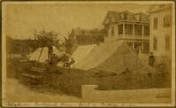
Caption: 'Cook's Earthquake Views of Charleston and Vicinity. Taken after the 31st of August, 1886. No.86, tents, Rutledge St[reet] Terrace.' Handwritten at bottom, front: 'Charleston Earthquake views - tents on Rutledge Terrace.'
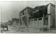
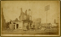
Charleston Earthquake scene. Copy of No.24 of Cook's Earthquake views. Shows damage to the buildings on the north side of Market Street, including the Sailor's Home.
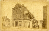
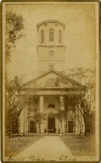
Caption: 'Cook's Earthquake Views of Charleston and Vicinity. Taken after the 31st of August, 1886. No.81, Flinn's Church.' Handwritten notation next to it and at bottom, front: '2nd Presbyterian Church.'
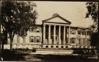
Photograph of front of Randolph Hall after the Charleston Earthquake of 1886. Damage to east wing visible on right. Both wings were eventually removed. Construction of Randolph Hall, the most recognizable building at the College, began in 1828 under the direction of architect William Strickland. Flanking wings and portico for the main building were designed by Edward Brickell White and erected circa 1850. In 1886 the wings were destroyed by the Charleston earthquake and rebuilt between 1888 to 1894 under the direction of Gabriel Manigault.
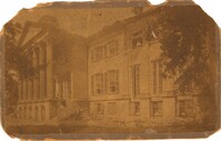
Photograph of front of Randolph Hall after the Charleston Earthquake of 1886. Rubble can be seen at base of east wing on right. Construction of Randolph Hall, the most recognizable building at the College, began in 1828 under the direction of architect William Strickland. Flanking wings and portico for the main building were designed by Edward Brickell White and erected circa 1850. In 1886 the wings were destroyed by the Charleston earthquake and rebuilt between 1888 to 1894 under the direction of Gabriel Manigault.
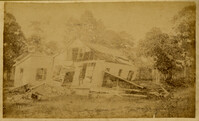
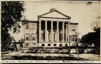
Photograph of front of Randolph Hall after the Charleston Earthquake of 1886. Both of the damaged wings have been removed. On bottom of photograph: " Charleston Earthquake views - Charleston College. Both Wings gone." Construction of Randolph Hall, the most recognizable building at the College, began in 1828 under the direction of architect William Strickland. Flanking wings and portico for the main building were designed by Edward Brickell White and erected circa 1850. In 1886 the wings were destroyed by the Charleston earthquake and rebuilt between 1888 to 1894 under the direction of Gabriel Manigault.
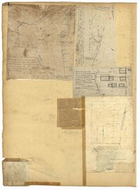
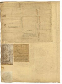
Page 184 of the City Engineer's Plat Book with five plats. Plat 1 shows "a certain plantation" near a "Marsh of Ashley." Plat 2 features a lot located on Congress Street, with several structures and streams. Plat 3 shows lots and structures located on Chesnut Street. Plat 4 shows lots and structures located on and near King Street, near its intersections with Romney Court and Simons Street.
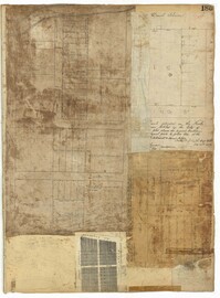
Page 185 of the City Engineer's Plat Book with four plats. Plat 1 shows lots and structures located near [Map too blurry to read, check when in-office]. Plat 2 shows lots and structures located near the intersection of Spring Street and Ashley Street. Plat 3 shows lots located near the intersection of Mount Street and Rutledge Avenue. Plat 4 shows lots located near Rutledge Avenue, between Congress Street and Huger Street.
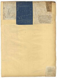
Page 164 of the City Engineer's Plat Book with three plats. Plat 1 shows lots located between Meeting Street and Aiken Street, and between Cooper Street and Line Street. Plat 2 shows lots located on Felix Street. Plat 3 shows lots located on Grove Street, and shows a stream and a label reading "Frenchman's Hill."
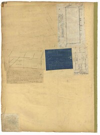
Page 150 of the City Engineer's Plat Book with five plats. Plat 1 shows lots located between President Street and the Ashley River, and between Spring Street and Mill Street. It also shows an "Ashley River Bridge" on Spring Street, and a lot labeled "Charleston and Savannah R.R." Plat 2 shows lots and structures located on the west side of Rutledge Avenue. Plat 3 features a lot located on the corner of St. Philips Street and Calhoun Street. Plat 4 shows lots located on the east side of Rutledge Avenue. Plat 5 shows lots and structures located on King Street, including labels reading "Upper Police Station" and "Cistern Underground."
Page 153 of the City Engineer's Plat Book with three plats. Plat 1 shows lots located between Rutledge Street and Lynch Street, near where they intersect with Calhoun Street. Plat 2 shows lots located on and near the intersection of Rutledge Avenue and a private court. Plat 3 shows lots located between Smith Street and Ogier Street, near where they intersect and Vanderhorst Street.