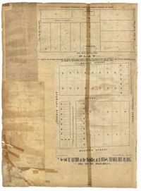
Page 160 of the City Engineer's Plat Book with four plats. Plat 1 shows a stretch of Mazyck Street, near its intersections with Queen Street and Short Street. Plat 2 shows lots and structures located on and near Reid Street, between Drake Street and Bay Street. Plat 4 shows lots and structures located between Nassau Street and Meeting Street, and between Stewart Street and Johnson Street.
1862, 1885, 1850, 1815, 1866, 1873, 1830, 1833, and 1787
Description:
Page 60 of the City Engineer's Plat Book with eight plats. Plat 1 shows lots near East Bay Street, and the intersection of Washington Street and Inspection Street. Plat 2 shows lots and a building located near Market Street. Plat 3 shows lots located between Washington Street and Marsh Street, and between Inspection Street and Calhoun Street. Plat 4 shows plots located on Market Street with a dotted line labeled "Line of Street proposed by the City." Plat 5 shows plots and structures located near East Bay Street. Plat 6 shows lots located near the intersection of Concord Street and Inspection Street. Plat 7 shows lots located near the intersection of Pinckney Street and East Bay Street. Plat 8 shows a dock and wharf on the Cooper River.
A report from the mayor, city council and various governmental departments of Charleston, South Carolina, for the year 1885. The Year Book opens with an address from Mayor Courtenay followed by reports from various departments and an appendix recounting the history of Charleston.
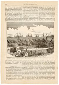
The illustration on the front page is captioned 'Interior of Fort Walker, at Hilton Head, immediately after its bombardment and evacuation'. The damage to the fort is in the foreground while in the background, sailing ships with small rowboats can be seen. On the verso are more illustrations. The top picture is captioned "Banks division crossing the Potomac previous to the Battle of Ball's Bluff." The left picture is captioned "Sinking of the peerless in a gale and rescue of the crew." The right illustration is captioned "Perilous position of a transport." The bottom picture is captioned "Capture of the steamer 'Fanny' by three Confederate steamers off Chicamicomica, N.C."
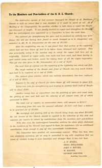
Letter to the members of St. Matthew's Lutheran Church- here abbreviated under its original name, the German Evangelical Lutheran Church- from the Building Committee, detailing repairs to the church after suffering hurricane ("cyclone") storm damage totaling $3,627, which in the committee's view should be raised by church members.
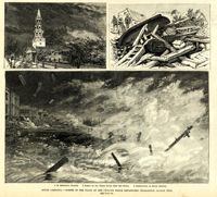
Main caption: 'South Carolina.--scenes in the track of the cyclone which devastated Charleston, August 25th. See page 43. 1. St. Michael's Church [upper left]. 2. Scene on the water front after the storm [top right]. 3. Destruction on South Battery [bottom].' [full date September 5, 1885.]
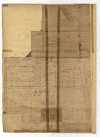
Page 230 of the City Engineer's Plat Book with one plat. The Plat features lots located between Chinquapin Street and President Street, and between Bee Street and Spring Street. It also shows several structures, Pine Street, and Chesnut Street. One lot is labelled "Vegetable Garden."