The illustration on the front page is captioned 'Interior of Fort Walker, at Hilton Head, immediately after its bombardment and evacuation'. The damage to the fort is in the foreground while in the background, sailing ships with small rowboats can be seen. On the verso are more illustrations. The top picture is captioned "Banks division crossing the Potomac previous to the Battle of Ball's Bluff." The left picture is captioned "Sinking of the peerless in a gale and rescue of the crew." The right illustration is captioned "Perilous position of a transport." The bottom picture is captioned "Capture of the steamer 'Fanny' by three Confederate steamers off Chicamicomica, N.C."
Letter to the members of St. Matthew's Lutheran Church- here abbreviated under its original name, the German Evangelical Lutheran Church- from the Building Committee, detailing repairs to the church after suffering hurricane ("cyclone") storm damage totaling $3,627, which in the committee's view should be raised by church members.
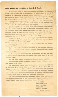
Main caption: 'South Carolina.--scenes in the track of the cyclone which devastated Charleston, August 25th. See page 43. 1. St. Michael's Church [upper left]. 2. Scene on the water front after the storm [top right]. 3. Destruction on South Battery [bottom].' [full date September 5, 1885.]
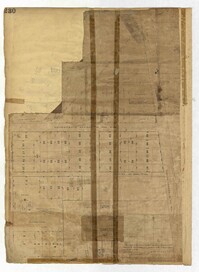
Page 230 of the City Engineer's Plat Book with one plat. The Plat features lots located between Chinquapin Street and President Street, and between Bee Street and Spring Street. It also shows several structures, Pine Street, and Chesnut Street. One lot is labelled "Vegetable Garden."
Page 234 of the City Engineer's Plat Book with one plat. The plat shows lots and structures located on Mill Street, President Street, Lucas Street, and Sixth Street. It also shows a lot labelled "U. S. Arsenal."
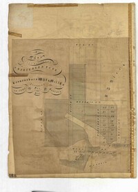
Page 231 of the City Engineer's Plat Book with one plat. The plat features lots belonging to "The Cannonsboro Whf & Mill Co." It shows Bee Street, Doughty Street, President Street, Lucas Street, and Mill Street.
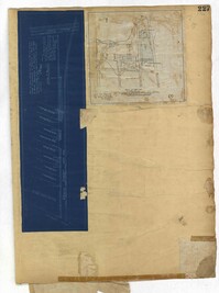
Page 227 of the City Engineer's Plat Book with two plats. Plat 1 shows lots and structures located on Grove Street, between King Street and Russell Street. Plat 2 features a "Plot of Ground Surrounding Charleston Colored Industrial School." Plat 2 also shows Fishburne Street, Mount Street, Congress Street, and President Street.
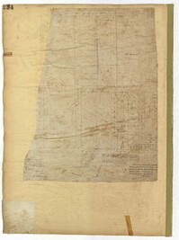
Page 212 of the City Engineer's Plat Book with three plats. Plat 1 shows lots located between Broad Street, Tradd Street, and Savage Street. Plat 2 shows lots and structures located near the intersection of Tradd Street and Chisolm Street, including wharves, a storehouse, a rice mill, an engine house, and a saw mill. Plat 3 shows lots, structures, and geographic features located between New Street and the Ashley River. Plat 3 also includes Tradd Street, Savage Street, Rutledge Street, Lynch Street, and a large stretch of marshland.