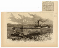
A newspaper sketch of a Mississippi tow boat on a river. There is a steamboat behind the tow boat. On the banks of the river is a man on a covered wooden boat.
The Rose Hill Time Book is a record of the tasks completed on the property and the figures related to pay for working these tasks starting in the month of May and ending in the month of July of 1878. Also included in this account are the names of the laborers on site. This location was once known as "Rose Hill Plantation" prior to the Civil War and this Time Book represents the agricultural labor of freedmen post Civil War during the era of Reconstruction. The names of the laborers are repeated throughout the record and are listed as: Abby, Adam, Affy, Annie, Bacus, Balinda, Beck, Berry, Bina, Bob, Ceasar, Charity, Charles, Charlott, Cinda, Cinty, Class, Cley, Cloe, Cudjoe, Dafney, Daniel, Dealia, Dick, Ealy, Eve, Fay, Flora, Franky, Friday, George, Gibbs, Hacklus, Hally, Hariott, Harry, Hera, Isaac, Israil/ Isreal, Jacob, James, Jane, January, Jenny, Jerry, Jim, Joe, John, Julia, Juliet, June, Juno, Katy, Lavinia, Liddy, Lindy, Lizet, Lucas, Luck, Lucy, Macky, Martha, Mingo, Mira, Molly, Morri, Nancy, Nilly, Patience, Peggy, Philip/Phillip, Pompy, Primas, Robert, Robin, Rocky, Salli/Sally, Sambo, Sary, Scipio, Sealy, Siby, Silvey, Simon, Smart, Titus, Toby, Tom, Tony.
The Rose Hill Time Book is a record of the tasks completed on the property and the figures related to pay for working these tasks starting in the month of July and ending in the month of December of 1878. Also included in this account are the names of the laborers on site. This location was once known as "Rose Hill Plantation" prior to the Civil War and this Time Book represents the agricultural labor of freedmen post Civil War during the era of Reconstruction. The names of the laborers are listed as: Abby, Adam, Bacus, Balinda, Ben, Berry, Bess, Billy, Bina, Binky, Blake, Brooks, Butler, Caroline, Catharina, Ceasar, Charity, Charlot, Chas, Cinty, Clay, Cloe, Curry, Dafney, Daniel, Dareus, David, Ellen, Eve, Fanny, Fay, Flora, Franky, Friday, Gibs, Hacklus, Hanah, Hariet , Hariott, Harot, Henry, Isaac, Israil, Jacob, James, Jane, January, Jerry, Jim/Jimm/Jimmy, Joana, Jock, John, Josiah, Judy, Julian, Jun, Laury ,Leah ,Leny, Lesby, Liddy, London, Luck , Maria, Mary, Maryann, Mily, Mingo, Morris, Moses, Ned , Patience, Patima, Patty, Peggy, Peter, Phillip, Pompy, Primus, Prince ,Queen, Richard ,Rob, Robert, Robin, Rose ,Saby, Sally, Sam, Sambo , Sampson ,Scilla, Scipio, Sealy, Sharlott, Silvey, Smart, Sory, Stephen, Tamar, Thomas, Toby, Tom, Tug, Violet, William.
The Rose Hill Time Book is a record of the tasks completed on the property and the figures related to pay for working these tasks starting in the month of January and ending in the month of May of 1878. Also included in this account are the names of the laborers on site. This location was once known as "Rose Hill Plantation" prior to the Civil War and this Time Book represents the agricultural labor of freedmen post Civil War during the era of Reconstruction. The names of the laborers are repeated throughout the record and are listed as: Abby, Adam, Balinda, Ben, Berry, Bina, Binky, Burry, Butler, Caesar, Charity, Charles, Charlot, Charot, Clarrida, Curly, Daniel, Daphney, Dareus, Edward, Ellen, Fay, Flora, Frank, Gibs, Hacklus, Hanah, Hariot, Harry, Henry, Isaac, Israil, Jacob, January, Jenny, Jerry, Jim/Jimmy, Joan, John, Judy, June, Juno, Leah, Linda, Lindy, Luck, Martha, Mary, Mingo, Miny, Mira, Morris, Nancy, Ned, Patty, Peggy, Phillip, Pompy, Queen, Richard, Robert, Robin, Rose, Sabe, Sally, Salvy, Sarah, Serpio, Silvey, Smart, Stephen, Tom, Violet.
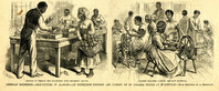
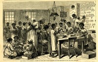
Main caption: 'American industries.--Silk culture in Alabama--an enterprise founded and carried on by Colored people at Huntsville.--from a sketch by A. Berghaus.' Caption left: 'Method of feeding the silkworms with mulberry leaves.' Caption right: 'Colored children carding the raw material.' [full date August 17, 1878.]
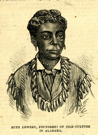
Caption: 'Main room of the Industrial Academy, in which the various processes for the production of raw silk are conducted.' [full date August 17, 1878.]
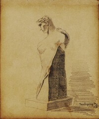
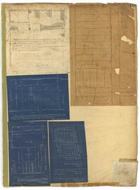
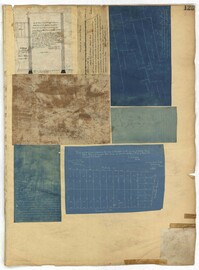
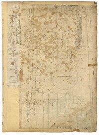
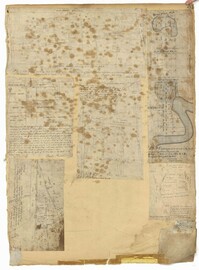
Pencil sketches and occassional watercolors by Charleston-born architect William Martin Aiken. The sketches are primarily buildings and architectural elements from Charleston, Boston, Rhode Island, France, England, Switzerland.
Pencil sketches by Charleston-born architect William Martin Aiken. Primarily images of buildings and architectural elements in Boston, Charleston, Atlanta, Virginia, North Carolina, New Hampshire, Montreal, and Quebec City.
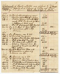
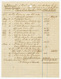
A statement on rents collected and distributed for the estate owned by Mrs. Eliza C. Ball with William Ball as her executor. The account also includes taxes and commissions.
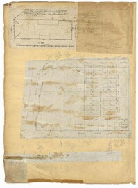
Page 139 of the City Engineer's Plat Book with five plats. Plat 1 shows a lot and structures located at the corner of Calhoun Street and Alexander Street. Plat 2 shows lots located on Queen Street, near where it intersects with Back Street. Plat 3 shows lots located on and near Mazyck Street, near its intersection with Magazine Street. Plat 3 also shows lots labelled "Roper Hospital Lot," and "City Lot." Plat 4 shows lots located between Vanderhorst Street and Boundary Street, and between Coming Street and Pitt Street.
Page 125 of the City Engineer's Plat Book with seven plats. Plat 1 shows several measurements for a structure. Plat 2 shows the line of division between St. Mary's Church Yard and the "Property of Mrs. Anna D. Fleming." Plat 3 shows two wharves. Plat 4 shows lots and structures near wharf street. Plat 5 shows lots near the intersection of Washington Street and Laurens Street. Plat 6 shows lots between Rose Lane and Market Street, near where they intersect with East Bay Street. Plat 7 shows lots between Congress Street and Race Street, near Rutledge Street.
Page 122 of the City Engineer's Plat Book with three plats. Plat 1 shows lots and structures on Meeting Street. Plat 2 shows lots and structures located near the intersection of Anson Street and Laurens Street. Plat 3 shows lots located between Moultrie Street and Huger Street, near Rutledge Avenue.
Page 119 of the City Engineer's Plat Book with five plats. Plat 1 shows land located between East Bay Street and the Cooper River. Plat 1 also shows Trott Street, Hasell Street, Concord Street, and Pinckney Street. Plat 2 features Bennett's Rice and Lumber Mills, near East Bay Street. Plat 3 features a plot on East Bay Street. Plat 4 features lots and structures located near Church Street and Market Street, and shows a lot labelled "Gas Company." Plat 5 shows lots located near the intersection of East Bay Street and Lodge Alley.
Page 81 of the City Engineer's Plat Book with five plats. Plat 1 shows lots between Cooper Street and Blake Street, near their intersections with Drake Street. Plat 2 features an extension of Columbus Street stretching from Bay Street to the Cooper River, and also shows lots belonging to a cotton factory, the Northeastern Railroad Company (N.E.R.R. Co.), and the South Carolina Railway Company (So. Ca. R. Way Co.). Plat 3 features lots on a city block between Blake Street, Cooper Street, Drake Street, and Bay Street. Plat 4 shows land near Boundary Street, Pinckney Street, Doughty Street, and "Commings Creek." It also shows an island, a mill pond, several lots in the area, Hutson Street, Thomas Street, and President Street. Plat 5 shows land located between Calhoun Street and Bull Street, and Lynch Street and Rutledge Street, including Cannon Park.
Page 65 of the City Engineer's Plat Book with six plats. Plat 1 shows wharves and other structures located near the intersection of East Bay Street and Elliott Street, and also shows a building labelled "Old Post Office." Plat 2 features a wharf on the Cooper River, and shows several structures. Plat 3 shows wharves and brick storehouses located near the intersection of Prioleau Street and Queen Street. Plat 4 shows lots near the intersection of Bull Street and Smith Street. Plat 5 shows lots and structures located near the intersection of King Street and Morris Street. Plat 6 shows land located along a stretch of Coming Street, between Race Street and Sumter Street.
Page 59 of the City Engineer's Plat Book with two plats. Plat 1 shows lots on East Bay Street, between Pritchard Street and Rose Lane. Plat 2 shows a lot and buildings belonging to the Charleston Gas Light Company, located on Church Street.
Page 41 of the City Engineer's Plat Book with six plats. Plat 1 shows land between Mount Street and Congress Street, and between a private street and "CITY LANDS Potter's Field." Plat 2 shows lots near Chestnut Street and near Spring Street, Ashton Street, Always Street, Lilly Street, and Pine Street. It also shows a few bodies of water. Plat 3 shows lots near Meeting Street's intersections with Market Alley, and State House Alley. It also labels a court house, the Treasury and Guard House, and St. Michael's Church. Plat 4 shows a stretch of land near President Street, Logan Street, Pinckney Street, Fishburne Street, Mount Street, Congress Street, and shows bodies of water and highlands. Plat 5 shows lots and buildings near the intersection Church Street and Water Street.