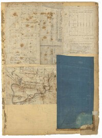
Page 81 of the City Engineer's Plat Book with five plats. Plat 1 shows lots between Cooper Street and Blake Street, near their intersections with Drake Street. Plat 2 features an extension of Columbus Street stretching from Bay Street to the Cooper River, and also shows lots belonging to a cotton factory, the Northeastern Railroad Company (N.E.R.R. Co.), and the South Carolina Railway Company (So. Ca. R. Way Co.). Plat 3 features lots on a city block between Blake Street, Cooper Street, Drake Street, and Bay Street. Plat 4 shows land near Boundary Street, Pinckney Street, Doughty Street, and "Commings Creek." It also shows an island, a mill pond, several lots in the area, Hutson Street, Thomas Street, and President Street. Plat 5 shows land located between Calhoun Street and Bull Street, and Lynch Street and Rutledge Street, including Cannon Park.