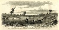
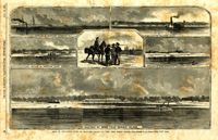
Caption: 'The War in Virginia--railroad bridges over the Rappahannock, at Rappahannock Station.--from a sketch by our Special Artist, Edwin Forbes.' [full date October 31, 1863.]
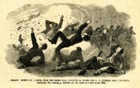
Caption: 'Terrified effects of a shell from a Rebel ram, bursting on board the U.S. gunboat Keystone State, January 31.--from a sketch by an Officer.--see page 365.' [full date February 28, 1863.]
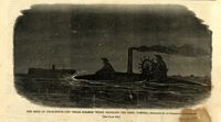
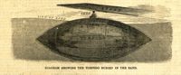
Caption: 'The siege of Charleston--the "Segar Steamer" which propelled the Rebel torpedo.--sketched by an occasional contributor. [see page 695.]' [full date October 31, 1863.]
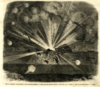
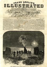
Caption: 'Siege of Charleston--the magazine of Fort Moultrie exploded by a shell from the grounded monitor Weehawken, Sept. 8.--from a sketch by our own Special Artist, W.T. Crane.' [full date October 3, 1863.]
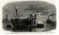
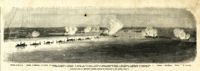
Caption: 'The Civil War in America: Confederates sinking torpedoes by moonlight in the harbour channel, Charleston.--from a sketch by our Special Artist.' [full date May 16, 1863.]
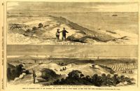
Caption: 'Siege of Charleston--views of the Northern and Southern ends of Morris Island, as seen from Fort Craig.--from sketches by our Special Artist, W.T. Crane.' Caption at top: 'North end of Morris Island.' Caption at bottom: 'South end of Morris Island.' [full date August 29, 1863.]
Caption: 'Our blockading fleet off North Channel, Charleston Harbor, South Carolina.--sketched by a Naval Officer.--[see page 79.] References--A. Fort Sumter.--B. Charleston City.--C. Fort Moultrie.--D. Rebel tug at work on the obstructions.--E. Obstructions.--F. Fort Johnson.--G. Mount Pleasant Batteries.' Also identified in image: South Carolina, Blunt, Daylight and Stars and Stripes (ships of the fleet). [full date January 31, 1863.]
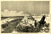
Caption: 'Middle-ground Battery, Charleston, S.C.--sketched by A.P. Palmer, 21st South Carolina Volunteers.--[see page 70.]' [full date January 31, 1863.]
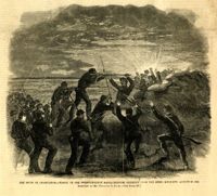
Caption: 'The Siege of Charleston--charge of the Twenty-Fourth Massachusetts Regiment upon the Rebel rifle-pits, August 26, 1863. Sketched by Mr. Theodore R. Davis.--[see page 621.]' [full date September 26, 1863.]
Caption: 'The siege of Charleston--View from the sea-face of Fort Wagner.--sketched by Mr. Theodore R. Davis.--[See Page 621.]' [full date September 26, 1863.]
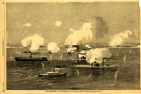
Caption: 'Panoramic view of Charleston Harbor--advance of iron-clads to the attack, April 7. Union--A. Keokuk. B. Nahunt. C. Nantucket. D. Catskill. E. Ironsides. F. Patapsco. G. Montauk. H. Passaie. K. Weehawken. Rebel--1. Morris Island sand battery. 2. Fort Wagner. 3. Battery Bee, on Cummings Point. 4. [Fort] Johnson. 5. Fort Ripley. 6. Sumter. 7. Charleston City. 8. Castle Pinckney. 9. Fort Redan. 10. Fort Moultrie. 11. Moultrie House. 12. Fort Beauregard. 13. Harbor obstructions. 14. Cooper River. 15. Ashley River.' [full date May 2, 1863.]
Caption: 'The bombardment of Fort Sumter, as seen through the "look out" in the pilot-house of one of the monitors, April 7.--from a sketch by our Special Artist.' [full date May 9, 1863]
Main caption: 'Siege of Charleston--views of Sullivan's Island, as seen from Morris Island.--from sketches by our Special Artist, W.T. Crane.' Caption top left: 'Remains of blockade runners.' Caption top right: 'Rebel camp on Sullivans Island.' Caption middle left and right: 'Rebel battery on Sullivans Island.' Caption middle: 'Examining passes on the beach.' Caption bottom: ' Fort Moultrie as seen from Morris Island.' [full date October 10, 1863.]