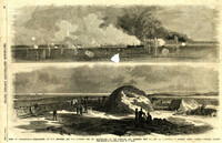
Caption: 'Siege of Charleston--1.Bombardment of Fort Moultrie and the Batteries Bee and Beauregard, by the monitors and ironsides, Sept. 7th and 8th.--2. Interior of Battery Gregg, looking towards Wagner. From sketches by our Special Artist, W.T. Crane.' [full date October 3, 1863.]
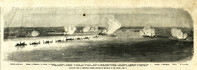
Caption: 'Panoramic view of Charleston Harbor--advance of iron-clads to the attack, April 7. Union--A. Keokuk. B. Nahunt. C. Nantucket. D. Catskill. E. Ironsides. F. Patapsco. G. Montauk. H. Passaie. K. Weehawken. Rebel--1. Morris Island sand battery. 2. Fort Wagner. 3. Battery Bee, on Cummings Point. 4. [Fort] Johnson. 5. Fort Ripley. 6. Sumter. 7. Charleston City. 8. Castle Pinckney. 9. Fort Redan. 10. Fort Moultrie. 11. Moultrie House. 12. Fort Beauregard. 13. Harbor obstructions. 14. Cooper River. 15. Ashley River.' [full date May 2, 1863.]
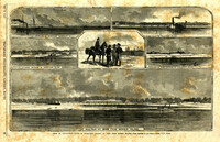
Main caption: 'Siege of Charleston--views of Sullivan's Island, as seen from Morris Island.--from sketches by our Special Artist, W.T. Crane.' Caption top left: 'Remains of blockade runners.' Caption top right: 'Rebel camp on Sullivans Island.' Caption middle left and right: 'Rebel battery on Sullivans Island.' Caption middle: 'Examining passes on the beach.' Caption bottom: ' Fort Moultrie as seen from Morris Island.' [full date October 10, 1863.]
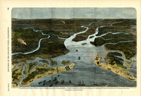
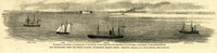
Caption: 'Our blockading fleet off North Channel, Charleston Harbor, South Carolina.--sketched by a Naval Officer.--[see page 79.] References--A. Fort Sumter.--B. Charleston City.--C. Fort Moultrie.--D. Rebel tug at work on the obstructions.--E. Obstructions.--F. Fort Johnson.--G. Mount Pleasant Batteries.' Also identified in image: South Carolina, Blunt, Daylight and Stars and Stripes (ships of the fleet). [full date January 31, 1863.]