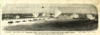
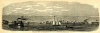
Caption: 'Panoramic view of Charleston Harbor--advance of iron-clads to the attack, April 7. Union--A. Keokuk. B. Nahunt. C. Nantucket. D. Catskill. E. Ironsides. F. Patapsco. G. Montauk. H. Passaie. K. Weehawken. Rebel--1. Morris Island sand battery. 2. Fort Wagner. 3. Battery Bee, on Cummings Point. 4. [Fort] Johnson. 5. Fort Ripley. 6. Sumter. 7. Charleston City. 8. Castle Pinckney. 9. Fort Redan. 10. Fort Moultrie. 11. Moultrie House. 12. Fort Beauregard. 13. Harbor obstructions. 14. Cooper River. 15. Ashley River.' [full date May 2, 1863.]
Caption: 'The bombardment of Fort Sumter, as seen through the "look out" in the pilot-house of one of the monitors, April 7.--from a sketch by our Special Artist.' [full date May 9, 1863]
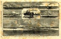
Main caption: 'Siege of Charleston--views of Sullivan's Island, as seen from Morris Island.--from sketches by our Special Artist, W.T. Crane.' Caption top left: 'Remains of blockade runners.' Caption top right: 'Rebel camp on Sullivans Island.' Caption middle left and right: 'Rebel battery on Sullivans Island.' Caption middle: 'Examining passes on the beach.' Caption bottom: ' Fort Moultrie as seen from Morris Island.' [full date October 10, 1863.]
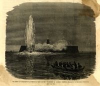
Caption: 'The siege of Charleston--attempt to blow up the "Ironsides" by a Rebel torpedo.--sketched by an occasional contributor. [see page 695.] [full date October 31, 1863.]
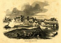
Caption: 'The Siege of Charleston--Johnsonville and Rebel fortifications.--[sketched from Black Island by Mr. Theodore R. Davis.]' [full date September 26, 1863.]