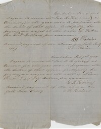
Short contract between W.L. Hadine (?), C.R. Hains and James B. Heyward to oversee two unnamed Heyward properties in 1858 and 1859. The handwritten document includes short statements from 1859 detailing the fulfillment of the contract. 1p.
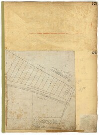
Page 171 of the City Engineer's Plat Book with three plats. Plat 1 shows lots located on and near the intersection of Meeting Street and Mt. Pleasant Street. Plat 2 shows lots located along King Street, near its intersection with Mt. Pleasant Street. Plat 3 shows the intersection of Calhoun Street and Smith Street.
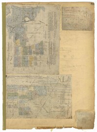
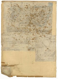
Page 85 of the City Engineer's Plat Book with three plats. Plat 1 shows the "Village of Hampstead," between Boundary Street and Mary Street, and between King Street and the Cooper River. The plat also shows City Lands, stretches of March, a stream, Wragg Square, the Mall, and Mazyckborough. Other streets shown include Washington Street, Alexander Street, Chapel Street, and Meeting Street. Plat 2 shows a similar stretch as Plat 1, but with different boundary lines for the lots. Plat 3 shows lots and structures located near King Street.
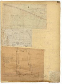
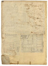
Page 40 of the City Engineer's Plat Book with three plats. Plat 1 shows lots located between Laurence Street and Boundary Street, and Anson Street and the Charleston Harbor on the Cooper River. Plat 1 also shows East Bay Street, Washington Street, Concord Street, several wharfs, marshland, and a label reading "Mazyck Borough." Plat 2 shows lots on Simmons Street, between King Street and a stretch of marshland. Plat 3 shows lots of land between New Street and Logan Street, and several buildings.
Page 28 of the City Engineer's Plat Book with three plats. Plat 1 shows lots located near Calhoun Street, Bull Street, South Street, Ashley Street, Rutledge Street Lynch Street, and Bennett Street. Plat 1 also shows lots labelled "The Mall," and Lots Belonging to Sundry Persons. Plat 2 shows lots and buildings located near the intersection of Calhoun Street and Lucas Street, including lots labelled "Mansion Lot" and "Left for a Public Square." Plat 3 shows lots and buildings located near Bee Street, between Ashley Street and Rutledge Street.
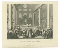
Black-and-white engraving of the interior of the Portuguese Synagogue in Amsterdam, during the celebration of Purim. Engraving by William Forrest after an engraving by Bernard Picart. From The faiths of the world : an account of all religions and religious sects, their doctrines, rites, ceremonies, and customs by James Gardner. Published London & Edinburgh: A. Fullarton & Co.
The Dr. Francis P. Porcher Prescription Book 1856-1859 records the patients, including enslaved people, of Dr. Francis Peyre Porcher. The descriptions state the names of the patients, the slave and their owner, the types of medicines that are being prescribed and specific ingredients for those medicines.
The Mulberry Plantation Journal for the years 1857-1860 was kept by overseer R. Meynardie who reported activities on the rice plantation. Entries note agricultural tasks, quantities of rice winnowed, sickness among slaves and individuals assinged to the nightly watch. The names of the slaves are listed throughout the journal as: Adeline, Amy, Ben, Betty, Binah, Bristol, C. Charles/Y.Charles, Carolina, Cilia, Clarinda, Florah, Frances, Hannah, Hariet, Isaac, Jack/Little Jack, Jacob/Little Jacob, Joe, Juba, Lindy, Little Judy/Young Judy, Maryan, Myra, Myrah, Ned/Old Ned, Paris, Peggy, Pierce, Sarah, Shamrocke and Venus.
The Robert F.W. Allston Account Book covers the years 1857-1859 discussing Chicora Wood and Nightingale Hall Plantations. The book includes information on acres of land, stock and cattle, payments and accounts, a purchase of forty-one enslaved persons and the number of enslaved persons at each plantation in which they are listed as dependencies. Book includes a second use with passages written from the back of the book towards the front.