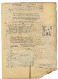
Page 11 of the City Engineer's Plat Book with five plats. Plat 1 shows a plot of land on the Charleston Harbor located near the intersection of East Bay Street and Queen Street. Plat 2 shows lots located between Conin Creek and King Street, and between Vanderhorst Street and "Manigault alias Boundary Street." Plat 3 shows plots and buildings located near the intersection of Liberty Street and St. Philip Street. Plat 4 features a plots, including one belonging to the "German Lutheran Church," located between King Street and Archdale Street.
Page 136 of the City Engineer's Plat Book with seven plats. Plat 1 shows lots and structures located on and near the intersection of Liberty Street and St. Philips Street. Plat 2 shows lots located on Archdale Street, near Bennett's Mill Pond. Plat 3 shows lots and structures located on and near the intersection of Rutledge Street and Montague Street. Plat 4 shows lots and structures located on Archdale Street, including a building labelled "Hope Engine House." Plat 5 shows a lot located along Clifford Alley, near a lot labelled "Unitarian Church." Plat 6 shows lots located along King Street. Plat 7 shows lots located on and near Calhoun Street, located between Smith Street and Rutledge Street.
Page 192 of the City Engineer's Plat Book with five plats. Plat 1 shows lots between Congress Street and King Street, from Gadsden Street to a city block past Moultrie Street. Plat 2 shows lots between Rutledge Street and King Street, and from Moultrie Street to a lot past Gadsden Street. Plat 3 shows a city block between Moultrie Street and Huger Street, and between Payne Street and Rutledge Street. Plat 4 shows lots near Rutledge Avenue, between Grove Street and Simons Street. Plat 4 also shows a street car line on Rutledge Avenue. Plat 5 shows lots between Sumter Street and Congress Street.
Page 186 of the City Engineer's Plat Book with two plats. Plat 1 shows lots and "City Lands" located near President Street, near its intersections with Mount Street and Congress Street. Plat 2 shows a farm located along the Ashley River, near Grove Street. Plat 2 also labels marshland, structures, fields, and lawn.
Page 182 of the City Engineer's Plat Book with three plats. Plat 1 shows lots and structures located along Spring Street, near its intersection and Chesnut Street. Plat 2 shows "the Schützenplatz," located at the end of Heriot Street. It also shows several structures, a marsh extending to the Ashley River, and a label reading "Known as the Village of Rikersville." Plat 3 shows lots and low land located near Meeting Street.
Page 90 of the City Engineer's Plat Book with four plats. Plat 1 shows lots located between King Street and Russell Street, near Grove Street and Poinsett Street. Plat 2 shows lots located between Meeting Street and King Street, with a strip of land labelled "S.C.R.R.," a common acronym for the South Carolina Rail Road. Plat 3 features lots located near Boigard Street. Plat 4 features land located on the Ashley River, near Grove Street, shows a stream and several structures.
Page 74 of the City Engineer's Plat Book with four plats. Plat 1 shows lots and some buildings located near Line Street, between King Street and a "Rail Road Company Road." Plat 2 shows lots located along Amherst Street, including one labelled "Cemetery of the Evangelical German Lutheran Church." Plat 3 shows land located between Washington Street and the Charleston Harbor, and includes several structures, a pond, docks, a wharf, and a canal. Plat 4 shows lots and some structures located near the intersection of Smith Street and Calhoun Street.
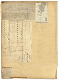
Page 45 of the City Engineer's Plat Book with nine plats. Plat 1 shows lots along New Street, located between Broad Street and Tradd Street, and shows an area labelled "City marshland." Plat 2 shows lots and buildings located between Queen Street and Cliffords Alley. Plat 3 shows land located near the intersection of Washington Street and Smith Street. Plat 4 shows lots and buildings located near the intersection of Green Street and "Comming Street." Plat 5 shows land located between "Boundary (Calhoun) Street" and George Street, and St. Phillip Street and "Comming Street," including a stretch of Green Street and College Street, and a lot labelled "College Lot." Plat 6 shows a lot located on the corner of Queen Street and King Street, and its buildings. Plat 7 shows lots located on Savage Street. Plat 8 shows lots located on Beaufain Street. Plat 9 shows lots near King Street, located between Boulevard Drive and South Bay Street.
Page 41 of the City Engineer's Plat Book with six plats. Plat 1 shows land between Mount Street and Congress Street, and between a private street and "CITY LANDS Potter's Field." Plat 2 shows lots near Chestnut Street and near Spring Street, Ashton Street, Always Street, Lilly Street, and Pine Street. It also shows a few bodies of water. Plat 3 shows lots near Meeting Street's intersections with Market Alley, and State House Alley. It also labels a court house, the Treasury and Guard House, and St. Michael's Church. Plat 4 shows a stretch of land near President Street, Logan Street, Pinckney Street, Fishburne Street, Mount Street, Congress Street, and shows bodies of water and highlands. Plat 5 shows lots and buildings near the intersection Church Street and Water Street.
Page 39 of the City Engineer's Plat Book with five plats. Plat 1 shows lots and some buildings along East Bay Street, between the intersections with Hassell Street and Cumberland Street. Plat 2 shows lots and some buildings located between Line Street and Shepherd Street. Plat 3 shows lots located between Queen Street and Magazine Street. Plat 4 features a lot and its buildings on King Street. Plat 5 features a lot at the intersection of East Bay Street and Rose Lane.
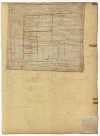
Page 31 of the City Engineer's Plat Book with two plats. Plat 1 shows lots located along a private street, between Mount Street and Congress Street. Plat 2 features lots located between Payne Street and Rutledge Street.
Page 7 of the City Engineer's Plat Book with four plats. Plat 1 shows lots on Bay Street. Plat 2 features plots on Hanover Street near the intersection with Reid Street and shows a lot labelled "African Burial Ground." Plat 3 features lots between Payne Street and Rutledge Street, near Fishburne Street and Market Street. Plat 4 shows lots and buildings near the intersection King Street and Broad Street. Plat 5 features lots on Cumberland Street.
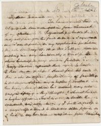
The Mulberry Plantation Journal for the years 1855-1856 was kept by overseers C.A. Ward and R. Meynardie who reported activities on the rice plantation. Entries note agricultural tasks, quantities of rice winnowed, weather conditions, sickness among slaves and individuals assinged to the nightly watch. The names of the slaves are listed throughout the journal as: Adeline/Adiline, Ben, Betty, Binah, Bristol, Charles/C. Charles/Cow Charles/Cow Charly/Young Charles, Carolina, Clarinda, Dinah, Fanny/Fany, Flora/Florah, Francis, Hanna/Hannah, Isaac, Jack/L. Jack/Little Jack, Jacob, Joe, Juba, Leah, Lewis, Lindy, Little Judy, Little Ned/Old Ned, Maryan, Myrah, Old Delia, Old Hariett, Paris/Parris, Patty, Pearce, Pierce, Sabrina, Sarah/Old Sara, Shammroc and Vinus
A conveyance of property to James Drayton from his brothers Thomas and John Drayton following the death of their mother Mary. Included in the conveyance are the following "negroes": Beck and her infant, Dick, Tyrah, Kate, Isaac, Charlie, Isaac the house servant, Tom, Phoeby, Joe, Nelly and her infant, Dianna, William, Lizzy, Miley, Mary, Jerry, Hannah, Bess, and Moses.
The Dr. Francis P. Porcher Prescription Book 1856-1859 records the patients, including enslaved people, of Dr. Francis Peyre Porcher. The descriptions state the names of the patients, the slave and their owner, the types of medicines that are being prescribed and specific ingredients for those medicines.
This multi-page document is a slave insurance policy by the Aetna Life Insurance Company to Thomas P. Allen. Enclosed is details on the insurance policy for the enslaved women listed as "Sebina" or "Sebrina" and her occupation as a washer.