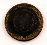
Slave auctioneer's token, 1846. These tokens were distributed as one-cent pieces and served as advertisements for the businesses and services depicted on the coins. Face view of token reads "W.W. Wilbur Auction & Commission Merchant; Charleston, So. Ca.; Going at Only A Penny" encircling the image of an auctioneer. Obverse view of token reads "Merchants & Manufactors Agents; Collection Broker Notary Public" encircling the image of a tree.
The Charles Manigault Letter Book, 1846-1848 is a bound volume kept by Charles I. Manigault while living in Paris, France with his family between 1846-1848. Letters were sent to James Coward, overseer at Silk Hope Plantation, Thomas Middleton, R. Habersham & Son, Alfred Huger, Anthony Barclay, Y. Haynes, overseer at Gowrie Plantation, Louis Manigault and Charles Manigault Jr. Topics of conversation found in these letters include business operations at the plantations, enslaved people's resistance via running away, treatment and punishment of slaves, a group of slaves taking an overseer to court, living abroad in Paris, Charles Manigault's views on racial equality in Paris, the Manigault children's schooling in Paris and at Yale College, traveling Europe, meeting Muhammad Ali, the leader of Egypt and discussing the Mexican American War and Egyptian politics, Charles Manigault's Huguenot ancestry and history, and being in Paris during the French Revolution of 1848.
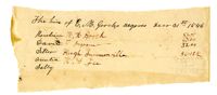
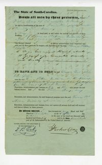
This document is a mortgage under the title "Mortgage of 7 Negroes" by Peter G. Gourdin to Samuel G. Barker. The enslaved are referred to as "negro slaves" throughout the document.
Page 121 of the City Engineer's Plat Book with six plats. Plat 1 shows lots located near the intersection of Washington Street and Society Street. Plat 2 shows lots located on East Bay Street. Plat 3 shows lots and structures located near the intersection of Wall Street and Minority Street. Plat 4 shows lots located between Concord Street and Wharf Street. Plat 5 shows lots and buildings on Cumberland Street. Plat 6 shows lots and structures located on and near Broad Street.
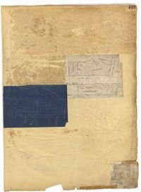
Page 107 of the City Engineer's Plat Book with two plats, labelled 3 and 4. Plat 3 features a lot and buildings located on the intersection or Tradd Street and East Bay Street. Plat 4 shows lots located near Gibbes Street, Tradd Street, New Street, and Savage Street. Plat 4 also shows three lines, labelled "Edge of high land," "Low water by Parker," and "Edge of Channel by Purcell and Parker."
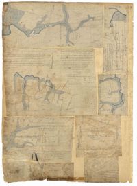
Page 88 of the City Engineer's Plat Book with eight plats. Plat 1 shows a stream and marshland starting at the Ashley River. Plat 2 features land located near the Ashley River and Grove Street. It also features several structures, some marshland, and a creek. Plat 3 shows land located near Grove Street, including some structures, some marshland, and a stream. Plat 4 shows land located Grove Street, including some buildings, a creek, and marshland. Plat 5 shows lots located between a stretch of marsh and Rutledge Avenue. Plat 5 also shows Congress Street, Legare Street, Huger Street, Moultrie Street, and a race track. Plat 6 features Washington Race Course, located between Grove Street and Moultrie Street, and between Congress Street and an unlabeled Street. Plat 7 shows "34 acres of Marsh" located between the Ashley River and a public cemetery. Plat 8 shows marshland located on the Ashley River, near "new Spring Street" and a creek.
Page 65 of the City Engineer's Plat Book with six plats. Plat 1 shows wharves and other structures located near the intersection of East Bay Street and Elliott Street, and also shows a building labelled "Old Post Office." Plat 2 features a wharf on the Cooper River, and shows several structures. Plat 3 shows wharves and brick storehouses located near the intersection of Prioleau Street and Queen Street. Plat 4 shows lots near the intersection of Bull Street and Smith Street. Plat 5 shows lots and structures located near the intersection of King Street and Morris Street. Plat 6 shows land located along a stretch of Coming Street, between Race Street and Sumter Street.
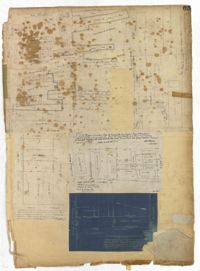
Page 50 of the City Engineer's Plat Book with seven plats. Plat 1 shows wharves and other structures located on East Bay Street. Plat 2 shows lots and buildings located on the intersection of Tradd Street and Meeting Street. Plat 3 shows lots located near the intersection of Broad Street and Rutledge Street. Plat 4 shows lots and buildings located near Gibbes Street. Plat 5 shows lots located near the intersection of Society Street and East Bay Street. Plat 6 shows lots and buildings near Broad Street. Plat 7 shows lots located between South Bay Street and the Ashley River, near Legare Street.