Page 101 of the City Engineer's Plat Book with two plats. Plat 1 shows lots located between Washington Street and Wharf Street, and between Calhoun Street and Laurens Street. Plat 2 shows lots located near the intersection of Rutledge Avenue and Line Street, with several buildings labelled.
Page 105 of the City Engineer's Plat Book with seven plats. Plat 1 shows several lots located on Chalmers Street. Plat 2 shows lots located near the intersection of East Bay Street and Market Street, and several structures, including docs and wharves. Plat 3 features lots and structures located on Chalmers Street. Plat 4 features a lot located on the intersection of Church Street and Waters Street, and shows several structures. Plat 5 shows a lot and several structures located on Waters Street. Plat 6 features a lot and buildings located on Broad Street. Plat 7 features the profiles of streets where tidal drains will be built. The profiles include Calhoun Street, Mazyck Street, Logan Street, Tradd Street, Coming Street, Chesnut Street, Spring Street, and Meeting Street.
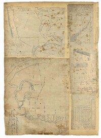
Page 106 of the City Engineer's Plat Book with ten plats. Plat 1 features a lot and its buildings located near the intersection of King Street and Tradd Street. Plat 2 features a lot and buildings located between Church Street and Water Street, near where the latter intersects with East Bay Street. Plat 3 shows lots located near the intersection of King Street and Grove Street. Plat 4 features a plat and building located on Church Street. Plat 5 features a lot located on the intersection of East Bay Street and Elliott Street. Plat 6 shows a lot located between two streets leading to wharves. Plat 7 shows lots, wharves, and docks located near the intersection of Market Street and East Bay Street. Plat 8 features a wharf and lot located near the intersection of Legare Street and South Bay Street. Plat 9 shows lots located on and near the intersection of Broad Street and East Bay Street. Plat 10 shows lots and some structures located on East Bay Street.
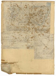
Page 140 of the City Engineer's Plat Book with six plats. Plat 1 shows lots and structures located on and near Queen Street, between King Street and Meeting Street. Plat 2 shows lots located on Rutledge Street. Plat 3 shows lots located between George Street and Burns Lane, near where they intersect with Meeting Street. One lot is labelled "Property of Charleston High School." Plat 4 shows lots and structures located between Lynch Street and the Ashley River, near Broad Street and Beaufain Street. Plat 5 shows lots and structures located on the corner of King Street and Society Street. Plat 6 shows the same area as Plat 5, but with some changes to the structures.
Page 78 of the City Engineer's Plat Book with five plats. Plat 1 features land and lots located near the Ashley River, including geographic features such as marshland, high land, and bodies of water. Plat 1 also shows Boundary Street, Hutson Street, Doughty Street, Bee Street, Elliot Street, Cannon Street, President Street, and Thomas Street. Plat 2 shows a city block between Doughty Street and Bee Street, and between President Street and Thomas Street, with some marsh labelled. Plat 3 features land and lots located near the Ashley River, with shoals and streams labelled. Plat 3 also shows Boundary Street, Pinckney Street, Cannon Street, Hutson Street, Doughty Street, and Bee Street. Plat 4 shows lots located near the intersection of Calhoun Street and Lucas Street, and shows several structures and a stretch of a creek. Plat 5 shows lots features lots located between Lucas Street and Ashley Street, and Mill Street and Doughty Street. Plat 5also shows Palmetto Street, President Street, and a lot labelled "U. S. Arsenal Square."
Page 40 of the City Engineer's Plat Book with three plats. Plat 1 shows lots located between Laurence Street and Boundary Street, and Anson Street and the Charleston Harbor on the Cooper River. Plat 1 also shows East Bay Street, Washington Street, Concord Street, several wharfs, marshland, and a label reading "Mazyck Borough." Plat 2 shows lots on Simmons Street, between King Street and a stretch of marshland. Plat 3 shows lots of land between New Street and Logan Street, and several buildings.
Page 2 of the City Engineer's Plat Book with five plats. Plat 1 shows the intersections of Guignard Street with East Bay Street and "Raper's Alley," and features a building labelled "Old Mansion Ruins." Plat 2 shows the intersection of East Bay Street and Market Street near the "Charleston Harbour on the Cooper River," and features plans to expand Market Street. Plat 3 features a stretch of land from the end of Rose Alley to the Cooper River, labelled as "Union Warf No. 1." Plat 4 features the same stretch of land as Plat 2 with slightly more land to the north. Plat 5 features the intersections of Tradd Street with Legare Street and Friend Street.
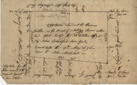
Copy of a plat of 200 acres on the neck of the Ashley River belonging to Thomas Butler. Only property outline and a few notes about the edges of the property are included. Names associated with this plat are Thomas Butler, Barker, John Bradford, and John Archdale. Notable geographic locations include the Ashley River, Clear Spring and St. Andrew's Parish.
1806, 1822, 1809, 1820, 1808, 1821, 1807, and 1810-1819
Description:
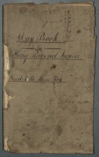
The Day Book for Henry Ravenel Junior, Wood Ville, 1806-1822, is a book divided into two sections. The first section lists the names of slaves and their decedents, lists of purchased slaves with name, name of previous owner, date and price, and slaves who received shoes. The second half, which appears upside down, records family events, visits to the Pineville theatre, traveling, engagements, marriages, deaths, and attendance at the Jockey Club. Also included are entries about a hunting party to capture or kill fugitive slaves, the promise of emancipation for two female "mulatto" child slaves, and a trial over the body of a slave woman who was punished to death. This book contains a second use written upside-down and back to front.
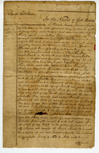
This document is the last will and testmament of Thomas Hunter Forrest. Includes the notation that he bequeathed his entire estate, including slaves (referenced as negro slaves) and household furniture, to "a certain mulatto boy named Frank or Frederick and lately emancipated by me." In the event that the boy dies before he reaches the age of twenty-one, the estate is bequeathed to the "Orphan House in the City of Charleston." Also makes the notation that his executors see that Frank or Frederick recieved a "good English education," learns a trade and that the "wench Sarah" is not to be sold in order to take care of Frank or Frederick.
The Travel Expenses Book, 1806-1810, is a bound volume kept by John Ball listing expenses for his travels to New York, Boston, Cambridge, Montreal, Quebec, Philadelphia, Bowling Green, Washington, Alexandria, Trenton, and other locations. Expenses are kept for food, clothing, lodging, and hiring servants. Notes indicate Mr. Ball's rating for service and fare at hotels and taverns in various locations.
Hand-colored etched satirical portrait of financier and philanthropist Abraham Goldsmid. Etching by Richard Dighton. Published by Dighton, 21 New Bond Street, August 1806.
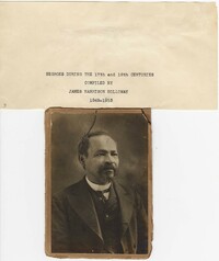
This scrapbook, compiled by James H. Holloway (1849-1913), contains legal documents, personal and business correspondence, receipts, ephemera, clippings and photographs pertaining to the Holloway family, a prominent free family of color in Charleston, SC. Legal documents include deeds (1806, 1821, 1871), a conveyance (1811), slave bills of sale including one for the slave "Betty" (1829), an agreement (1829) to apprentice the slave boy Carlos in the carpenters and house joiner's trade, exhorter licenses to preach and a photograph of a 1797 document declaring patriarch Richard Holliday (Holloway) a free mulatto. Personal and business correspondence include letters concerning the hiring out of slaves, an offer (1837) to buy the "Holloway Negroes", a letter (1831) from Samuel Benedict about emigrating to Liberia, agreements for carpentry work, and information about the Brown Fellowship Society, the Century Fellowship Society, the Minors Moralist Society and the Bonneau Literary Society. Also included are invitations, Confederate and corporate tax receipts, receipts for general merchandise, and Confederate scrip. Other letters and newspaper clippings, including letters to the editor written by James H. Holloway, concern Negro taxes, Negro slaveholders, the Liberia movement, the Methodist Episcopal Church, civil rights and related topics. James H. Holloway's niece, Mae Holloway Purcell, preserved the scrapbook after his death and added to its contents. The bound scrapbook was microfilmed by the South Caroliniana Library in 1977 but was later disbound and reorganized. Using the microfilm as a guide, archivists at the Avery Research Center attempted to recreate the original order and this digital presentation of the scrapbook reflects those efforts.