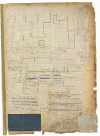
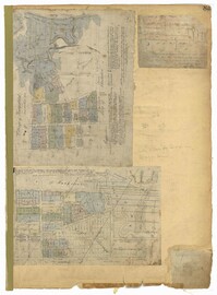
Page 1 of the City Engineer's Plat Book with four plats. Plat 1 shows the intersection of East Bay Street and Market Street, and labels reading "New Custom Ho.," "Old Flash," "Scale House," and "Market." Plat 2 shows a stretch of East Bay Street from the intersection with Guignard Street to Pritchard Street, including the bridge crossing over Canal Street. Plat 3 shows the intersection of Tradd Street and Greenhill Street. Plat 4 features Beaufain Street's intersections with St. Phillip Street and Archdale Street, and features a plot of land labelled "Normal School Yard."
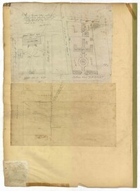
Page 132 of the City Engineer's Plat Book with two plats. Plat 1 features a plan for the College of Charleston, showing buildings labelled "Charleston College," "Library," "Lodge," and "Charleston Orphan House." Streets on this plat include George Street, Smith Street, College Street, Calhoun Street, St. Philips Street, and Vanderhorst Street. Plat 2 shows lots located near the intersection of Montague Street and Lynch Street.
Page 16 of the City Engineer's Plat Book with five plats. Plat 1 shows lots close to the Ashley River located near Tradd Street and Gibbes Street, including a marsh flat labelled as "City Lands." Plat 2 shows lots located near the intersection of Tradd Street and Council Street, including "City marshlands." Plat 3 shows lots located near Gibbes Street and South Bay Street, and includes a dotted line labelled "Low Water Mark." Plat 4 shows land located between Ellery Street and Old Church Street, including a stretch of Raper Street. Plat 5 shows land near the intersection of South Bay Street and "Legare or Johnson Street," and close to the "Low Water" of the Ashley River.
Page 99 of the City Engineer's Plat Book with four plats. Plat 1 shows land located near Meeting Street, between Williams Street and Semmes Street. Plat 1 also shows Nassau Street, Romney Street, some marshland, and New Market Creek. Plat 2 shows a lot with two structures located on Laurel Street. Plat 3 features lots located between Congress Street and Gadsden Street, near Pinckney Street. Plat 4 features lots located along Mount Street, between President Street and Payne Street.
Page 85 of the City Engineer's Plat Book with three plats. Plat 1 shows the "Village of Hampstead," between Boundary Street and Mary Street, and between King Street and the Cooper River. The plat also shows City Lands, stretches of March, a stream, Wragg Square, the Mall, and Mazyckborough. Other streets shown include Washington Street, Alexander Street, Chapel Street, and Meeting Street. Plat 2 shows a similar stretch as Plat 1, but with different boundary lines for the lots. Plat 3 shows lots and structures located near King Street.
Page 73 of the City Engineer's Plat Book with six plats. Plat 1 shows lots and some buildings located near the intersection of Chapel Street and Alexander Street. Plat 2 shows lots located near King Street's intersections with Radcliffe Street, Vanderhorst Street, Hutson Street, John Street, and Ann Street. The plat also shows Meeting Street, the Mall, and a body of water. Plat 3 shows lots, structures, and marshland located near the intersection of Coming Street and Smith Street. Plat 4 shows lots and some buildings located near John Street, between King Street and a some "Rail Road Land." Plat 5 shows lots located near King Street, between Tobacco Street and Calhoun Street. Plat 6 features a stretch of land between King Street and Meeting Street, along John Street's north side and near Radcliffe Street. The plat also shows a feature labelled "Ravine."
Page 53 of the City Engineer's Plat Book with five plats. Plat 1 shows shoals and marshlands located near the Ashley River Channel, Gibbes Street, and South Bay Street. Plat 2 features a lot and its buildings at the intersection of Broad Street and New Street. Plat 3 shows a lots and buildings located on Tradd Street. Plat 4 features lots and buildings located near the intersection of Broad Street and Tradd Street, including some stretches of marshland. Plat 5 shows lots located near Broad Street's and Tradd Street's intersections with New Street and Legare Street.
Page 45 of the City Engineer's Plat Book with nine plats. Plat 1 shows lots along New Street, located between Broad Street and Tradd Street, and shows an area labelled "City marshland." Plat 2 shows lots and buildings located between Queen Street and Cliffords Alley. Plat 3 shows land located near the intersection of Washington Street and Smith Street. Plat 4 shows lots and buildings located near the intersection of Green Street and "Comming Street." Plat 5 shows land located between "Boundary (Calhoun) Street" and George Street, and St. Phillip Street and "Comming Street," including a stretch of Green Street and College Street, and a lot labelled "College Lot." Plat 6 shows a lot located on the corner of Queen Street and King Street, and its buildings. Plat 7 shows lots located on Savage Street. Plat 8 shows lots located on Beaufain Street. Plat 9 shows lots near King Street, located between Boulevard Drive and South Bay Street.
Page 39 of the City Engineer's Plat Book with five plats. Plat 1 shows lots and some buildings along East Bay Street, between the intersections with Hassell Street and Cumberland Street. Plat 2 shows lots and some buildings located between Line Street and Shepherd Street. Plat 3 shows lots located between Queen Street and Magazine Street. Plat 4 features a lot and its buildings on King Street. Plat 5 features a lot at the intersection of East Bay Street and Rose Lane.
Page 23 of the City Engineer's Plat Book with one plat. The plat shows lots, buildings, shoals, and mud flats located near the Charleston Harbor on the Cooper River, Concord Street, Pinckney Street, and East Bay Street.