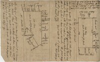
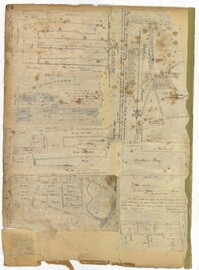
Copy of two adjoining plats of lands on Johns Island originally granted to Ambrose Hill now belonging to Miller St. John. Copied from the plats annexed to the original grants in 1795. Names associated with these plats are Ambrose Hill, Miller St. John, Richard Floyd, the Lords Proprietors, Job Howe, N. Johnson, Thomas Broughton and Lambert Lanee. Notable geographic locations include Johns Island, Ambrose Hill, Bohicket Creek, and Colleton County.
Plat of two tracts of land on Johns Island, both are 300 acres. Notes give a brief description of the properties, the drawings include very little detail. Names associated with this plat include John Prescot, Anthony Mathews, Graemede, the Lords Proprietors, Robert Cole, Robert Gibbs, Heufville, Arnold, Richard Floyd and Thomas Broughton. Notable geographic locations include Colleton County, Kywah [Kiawah] Creek, and Johns Island.
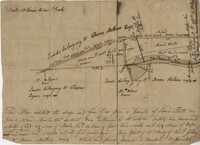
True copy of a plan surveyed for an inland plantation for Breton Singletary containing 500 acres situated in Craven County butting and bounding northerly on late William North, southerly by Singletary and all other sides on lands not yet laid out. Names associated with this plat are Thomas Broughton, Breton Singletary, Richard Beresford, William North, Charles Craven, Alexander Heward, John St. Martin, Thomas Valley, Mary Henry, and Robert Smith. Notable geographic locations include Wambaw, St. Thomas Parish, and Craven County [now in parts of Berkeley, Charleston, Georgetown, and Williamsburg counties].
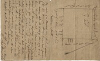
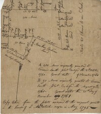
Plan of a parcel of land situated on Johns Island and containing 86 1/2 acres. Being part of a body of land belonging to Thomas Mathews. Bounded northwardly by a public road, eastwardly on James Legare's land, and southwardly on land belonging to Isaac Holmes and Thomas Legare. Intended to be conveyed to Isaac Holmes. Names associated with this plat are Thomas Mathews, Isaac Holmes, Thomas Legare, William Stanyarn, Matthews and James Legare.
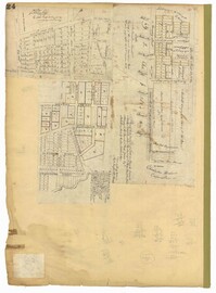
Page 162 of the City Engineer's Plat Book with three plats. Plat 1 shows land located near Payne Street with several streams. Plat 2 shows lots located in the Village of Hampstead, located near America Street. The plat also shows marshland and streams. Plat 3 has numerous tears and holes. Plat 4 shows lots and structures located between Meeting Street and Lynch Street.
Page 64 of the City Engineer's Plat Book with six plats. Plat 1 features wharves near Concord Street and shows several other structures. Plat 2 shows "Dock Street or Queen Street" located towards the south, a structures and a creek near the center, and a lot labelled "Capt. Balls Lot" towards the north. Plat 2 also has a large label reading "Cooper River." Plat 3 shows lots located near Cumberland Street between Church Street and Philadelphia Street, and shows several structures on the lots. Plat 4 shows wharves and several buildings located between East Bay Street and the Cooper River. Plat 5 shows a stretch of land between King Street and a body of water, and also shows a stretch of Hasell Street. Plat 6 shows lots on Queen Street, and includes a lot labelled "St. Philips Church Yard." Plat 7 shows lots located near Queen Street, and has a label reading "St. Philips Church Yard."
Page 24 of the City Engineer's Plat Book with three plats. Plat 1 shows lots located near King Street, Meeting Street, Wolf Street, March Lane, and Reid Street, including a portion of land labelled "Old fish pond low & broken land" and large label reading "Part of Hampstead." Plat 2 shows lots and features near the Charleston Harbor on the Cooper River, Boundary Street, Charlotte Street, Washington Street, and East Bay Street, and notes the "High Water Mark at Common Tides." Plat 3 shows lots located Meeting Street, Elizabeth Street, Ann Street, John Street, "Chapple Street," Alexander Street, and Washington Street, including a lot labelled "Tobacco Inspection."
Copy of a plat of 490 acres owned by Francis Smith annexed to the lands owned by Laughlin McIntosh. Names associated with this plat are Francis Smith, Laughlin McIntosh, Beadon Colonel, Captain Hutchinson, and Thomas Fleming. Notable geographic locations include St. Bartholomew's Parish, Chickaw and Charleston District.