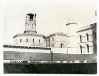
Caption: 'Charleston Earthquake. Photographs by Dr. E.P. Howland, taken on his visit to Charleston and the earthquake region of Ten Mile Hill and Summerville. Over 150 Photographs were taken. Charleston Jail and cracked wall, unsafe and condemned.'
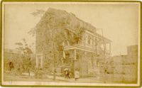
Caption: 'Cook's Earthquake Views of Charleston and Vicinity. Taken after the 31st of August, 1886. No.78, Residence Wm. Johnson, Wentworth Street.' Charleston city directory for 1886 shows a William Johnson at 107 Wentworth Street.
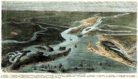
[Color image.] Caption (in French): 'Evenements des Etats-Unis: Charleston et ses fortifications. [Events of the United States: Charleston and its fortifications.] 1--Charleston. 2--Riviere Ashley [Ashley River]. 3--Chemin de fer de Savannah [Savannah Railway]. 4--Riviere Cooper [Cooper River]. 5--Riviere Wando [Wando River]. 6--Fort Pinkney [Castle Pinckney]. 7--Fort Ripley. 8--Fort Johnson (ile James) [James Island]. 9--Riviere Stone [Stono River]. 10--Fort Sumter. 11--Fort Moultrie. 12--Batterie Gregg (pointe de Gumming) [Battery Gregg (Cummings Point)]. 13--Fort Wagner. 14--Batteries rasantes du general Gilmore [grazed batteries of General Gilmore]. 15--Ouvrages pris par les federaux. [Works undertaken by the Federals]. 16--Phare Inlet [Lighthouse inlet]. 17--Batteries federales (ile Folly) [Federal Batteries (Folly Island)]. 18--Canonnieres et vaisseaux cuirasses [gunboats and ironclads]. 19--Hotel. 20--Ile et batteries Sullivan [Sullivan Island and Batteries]. 21--Moultrie. 22--Mont Pleasant [Mount Pleasant]. 23--Breach Inlet. 24--Shem Creek. 25--Batteries construite par les confederes sur l'ile James, dans le voisinage du fort Johnson [Batteries built by the Confederates on James Island, in the vicinity of Fort Johnson].
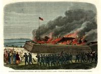
[Color image.] Caption (in French): 'Les troupes federales evacuant le fort Moultrie, apres avoir detruit le materiel de guerre.--D'apres les croquis de M.W.S. (Voir la Revuie de la semaine.)' [Federal troops evacuate Fort Moultrie, after destroying war materials.--from the sketch by M.W.S. (see the Review of the Week)].
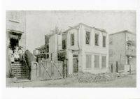
Charleston Earthquake scene. Possibly from Cook's Earthquake Views. No.68, John Kenney, Tradd Street. Charleston city directory for 1886 shows listing for John B. Kenney at 142 Tradd.
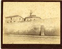
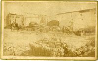
Caption: 'Cook's Earthquake Views of Charleston and Vicinity. Series No.2. No.190, Kerr's Wharf. Charleston city directory for 1886 lists Kerr's Wharf as opposite Cordes.