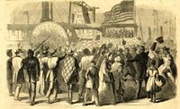
Caption: 'Enthusiastic crowd of citizens of Charleston, S.C., assembled on Vanderhost's (sic) Wharf, Feb. 20, to greet the second visit of Gen. Gillmore and staff.--sketched by our Special Artist.' [full date March 25, 1865.]
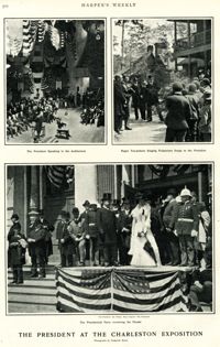
Main caption: 'The President at the Charleston Exposition. Photographs by Frederick Moore.' Caption top left: 'The President speaking in the auditorium.' Caption top right: 'Negro tea-pickers singing pickaninny songs to the President.' Caption bottom center: 'The presidential party reviewing the parade.' Further captioning identifies: 'The President, Sec. Wilson, Mayor Smythe, Mrs. Roosevelt.'
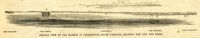
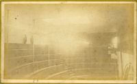
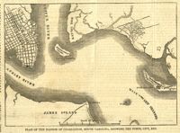
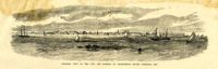
Caption: 'Profile view of the harbor of Charleston, South Carolina, showing the city and forts.' Identified in the image: Fort Johnston (sic), Fort Sumter, Charleston, Fort Moultrie and Mount Pleasant. [full date December 29, 1860.]
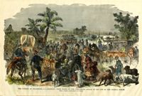
[Color image.] Caption: 'The citizens of Charleston, S.C., deserting their homes, on the threatened attack of the city by the Federal Forces. From a Sketch by Lieutenant G.P. Kirby.'
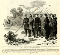
Caption: 'Escorting Major Taylor, of New Orleans, the bearer of a flag of truce, blindfolded, to the Confederate lines, after his unsuccessful mission.'
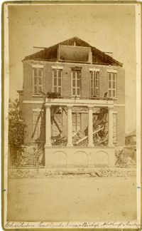
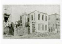
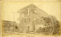
Caption: 'Cook's Earthquake Views of Charleston and Vicinity. Taken after the 31st of August, 1886. No.40, Bishop's house, Broad Street.' Handwritten at bottom, front: 'Charleston Earthquake scene - Bishop Northrup's Residence.' Charleston city directory for 1886 shows Bishop Henry P. Northrop at 114 Broad Street.
Caption: 'Cook's Earthquake Views of Charleston and Vicinity. Taken after the 31st of August, 1886. No.150, Mariner's Church, exterior." Also, handwritten at bottom of image: 'Charleston Earthquake scene - Mariners' Church, Church Street ? East Bay'
Caption: Cook's Earthquake View of Charleston and Vicinity. Taken after the 31st of August, 1886. No.151, Mariner's Church, interior.' Also, handwritten at bottom, front: 'Charleston Earthquake scene - Interior of Mariners' Church, on Church Street.'
Caption: 'Cook's Earthqauke Views of Charleston and Vicinity. Taken after the 31st of August, 1886. No.126, East Bay, corner Queen Street.' Sign on building reads: 'Ship & Family Groceries.' Possibly J.J.W. Luden, retail grocers and ship chandlers, located 167-169 East Bay, according to the 1886 Charleston city directory.
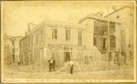
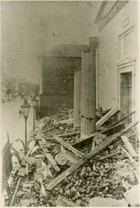
Caption: 'Cook's Earthquake Views of Charleston and Vicinity. Taken after the 31st of August, 1886. No.22, Broad Street, north side.' Charleston Insurance & Trust, Co. is shown to the left. Charleston city directory for 1886 lists it as Ravenel, Johnson & Co. at 12 Broad Street.
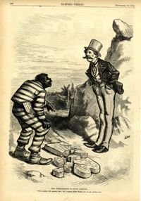
Political cartoon, caption: 'The Commandments in South Carolina. "We've pretty well smashed that; but I suppose, Massa Moses, you can get another one."' [full date September 26, 1874]
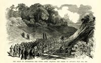
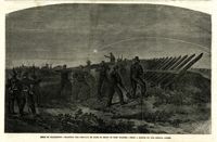
Caption: 'Siege of Charleston--planting the chevaux de frise in front of Fort Wagner.--from a sketch by our Special Artist.' [full date September 26, 1863.]
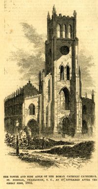
Caption: 'The tower and side aisle of the Roman Catholic Cathedral, St. Finbar, Charleston, S.C., as it appeared after the Great Fire, 1862.' [full date November 1, 1862.]
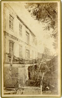
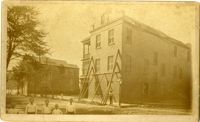
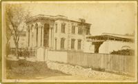
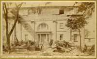
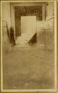
Charleston Earthquake scene, residence on Ashley Street. Handwritten on reverse: 'The residence of the Mayor of Charleston shattered by the Earthquake, Aug[us]t 31st 1886 and occupied by the Mayor's family unitl May 1887. Courtnay's [sic] residence. E.V.V. made bust of this man.'
Caption: 'Cook's Earthquake Views of Charleston and Vicinity. Taken after the 31st of August, 1886. No.38, Bagging Factory, East end.' Charleston city directory for 1886 shows the office of the Charleston Bagging Manufacturing Company at 110 East Bay. Written on front, at bottom: 'Charleston Earthquake Scene - Rear of Bagging Factory.'
Caption: 'Cook's Earthquake Views of Charleston and Vicinity. Taken after the 31st of August, 1886. No.67, G.W. Williams, Jr., Atlantic Street.' Charleston city directory for 1886 shows George W. Williams, Jr. at 2 Atlantic Street.
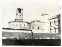
Caption: 'Cook's Earthquake Views of Charleston and Vicinity. Taken after the 31st of August, 1886. No.5, Medical College.' Handwritten at bottom, front: 'Charleston Earthquake scene - Charleston Medical College. Queen Street.'
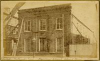
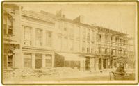
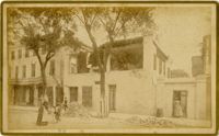
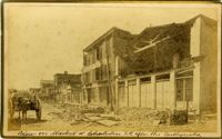
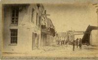
Caption: 'Cook's Earthquake Views of Charleston and Vicinity. Taken after the 31st of August, 1886. No.24, Market Street, north side.' Charleston Port Society building is pictured. Written on front, at bottom: 'View on Market St. at Charleston, S.C. after the Earthquake.'
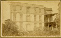
Caption: 'Cook's Earthquake Views of Charleston and Vicinity. Taken after the 31st of August, 1886. No.131, residence J.N. Robson, south side.' Charleston city directory for 1886 shows James N. Robson at 200 Coming Street.
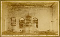
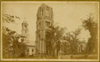
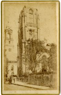
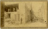
Caption: 'Cook's Earthquake Views of Charleston and Vicinity, Series No.2. No.153, Main aisle of St. Michael's Church, showing fissures and upheavals.'
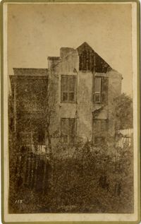
Charleston Earthquake scene. Possibly from Cook's Earthquake Views. No.68, John Kenney, Tradd Street. Charleston city directory for 1886 shows listing for John B. Kenney at 142 Tradd.
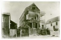
Charleston Earthquake Scene. Possibly from Cook's Earthquake Views, No.56, Alderman Murray's residence, Wentworth Street.' Charleston city directory for 1886 shows Andrew B. Murray at 175 Wentworth.
Charleston Earthquake scene. Written on front, at bottom: 'Charleston Earthquake scene - warehouse on Atlantic Wharf.' Charleston city directory for 1886 lists Atlantic Wharf at the rear of the Post Office.
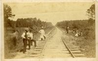
Charleston Earthquake scene. Handwritten on reverse: '9 mile bottom - South Carolina railroad - chasm on left. Track was originally a tangent. Caused by earthquake, 1886. Track cut of line.'
Caption: 'Cook's Earthquake Views of Charleston and Vicinity. Taken after the 31st of August, 1886. No.93, No.11 King Street.' Written on front, at bottom: 'Charleston Earthquake scene - Private residence on King St. near South Battery.'