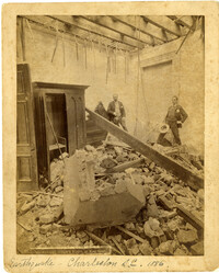
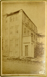
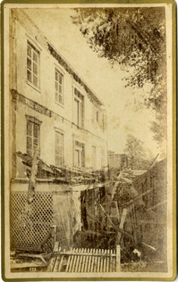
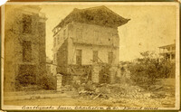
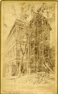
Charleston Earthquake scene. Sign at bottom of image: 'Mr. August Melm's room, 21 King Street.' Also, written on front, at bottom: 'Earthquake - Charleston S.C. 1886.' Charleston city directory for 1886 lists August Melm, a local attorney, as boarding at 21 King Street.
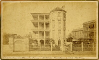
Caption: 'Cook's Earthquake Views of Charleston and Vicinity. Taken after the 31st of August, 1886. No.66, _____ Alston, East Battery.' Charleston city directory for 1886 shows various members of the Alston family at 21 East Battery.
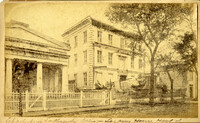
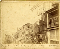
Charleston Earthquake scene. Written on reverse: 'East Battery, just below Atlantic Street. Edmonston [sic] House, later the Charles Alston residence. Now (1947) the residence of J.J. Pringle Smith. Old Holmes house on left. Earthquake of 1886 - Charleston, S.C.'
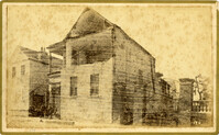
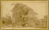
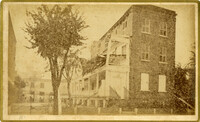
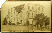
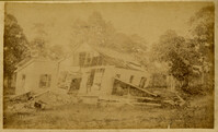
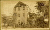
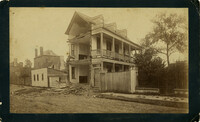
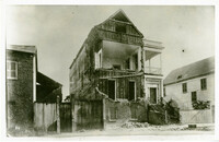
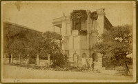
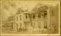
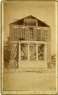
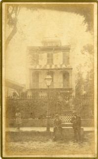
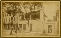
Charleston Earthquake scene, residence on Ashley Street. Handwritten on reverse: 'The residence of the Mayor of Charleston shattered by the Earthquake, Aug[us]t 31st 1886 and occupied by the Mayor's family unitl May 1887. Courtnay's [sic] residence. E.V.V. made bust of this man.'
Caption: 'Cook's Earthquake Views of Charleston and Vicinity. Series No.2. No.167, rear of residence of Geo. [George] W. Williams, Jr.' Charleston city directory for 1886 shows George W. Williams, Jr. at 2 Atlantic Street.
Caption: 'Cook's Earthquake Views of Charleston and Vicinity. Taken after the 31st of August, 1886. No.67, G.W. Williams, Jr., Atlantic Street.' Charleston city directory for 1886 shows George W. Williams, Jr. at 2 Atlantic Street.
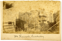
Charleston Earthquake scene. Possibly from Cook's Earthquake Views, no.63. William Ravenel, East Battery, rear. Written on front, at bottom: 'Wm Ravenel's, East Battery.'
Caption: 'Cook's Earthquake Views of Charleston and Vicinity. Taken after the 31st of August, 1886. No.65, _____ Holmes, East Battery.' Written on front, at bottom: 'Charleston Earthquake scene - Holmes residence, East Battery.' Charleston city directory for 1886 shows Charles R. Holmes, Jr., at 19 East Battery.
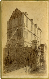
Caption: 'Cook's Earthquake Views of Charleston and Vicinity. Taken after the 31st of August, 1886. No.62, Wm. [William] Ravenel, East Battery, front.' Written on front, at bottom: 'Earthquake scene, Charleston, So.Ca. - Ravenel House'
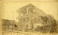
Caption: 'Charleston Earthquake. Photographs by Dr. E.P. Howland, taken on his visit to Charleston and the earthquake region of Ten Mile Hill and Summervile. Over 150 Photographs were taken. House of Mr. Ravenell [sic], President Northeastern R.R.'
Caption: 'Cook's Earthquake Views of Charleston and Vicinity. Taken after the 31st of August, 1886. No. 55, Major R.C. Gilchrist, Bee St[reet].' Charleston city directory for 1886 shows Robert C. Gilchrist at 12 Bee Street.
Caption: 'Cook's Earthquake Views of Charleston and Vicinity. Series No.2. No.181, Beresford Street.' This may be Beresford Alley which is also known as Clifford Street.
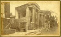
Caption: 'Cook's Earthquake Views of Charleston and Vicinity. Taken after the 31st of August, 1886. No.40, Bishop's house, Broad Street.' Handwritten at bottom, front: 'Charleston Earthquake scene - Bishop Northrup's Residence.' Charleston city directory for 1886 shows Bishop Henry P. Northrop at 114 Broad Street.
Caption: 'Cook's Earthquake Views of Charleston and Vicinity. Taken after the 31st of August, 1886. No.91, Brawley House, Legare Street.' Charleston city directory for 1886 shows Wm. H. Brawley at 9 Legare Street.
Caption: 'Cook's Earthquake Views of Charleston and Vicinity. Series No.2. No.170, Buist residence, Rutledge Street.' Written on front, at bottom: Buist Residence, 43 Rutledge St.' Charleston city directory for 1886 shows listing for Samuel S. Buist at 43 Rutledge Avenue.
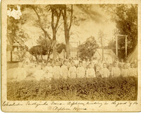
Caption: 'Charleston Earthquake. Photographs by Dr. E.P. Howland, taken on his visit to Charleston and the earthquake region of Ten Mile Hill and Summerville. Over 150 photographs were taken. Orphans and tents in which they lived.' Written on front, at bottom: 'Charleston Earthquake scene - orphans, standing the yard of the Orphan House.'
Caption: 'Charleston Earthquake. Photographs by Dr. E.P. Howland, taken on his visit to Charleston and the earthquake region of Ten Mile Hill and Summervile. Over 150 Photographs were taken. House of Mrs. Snowden, President of Confederate Home.'
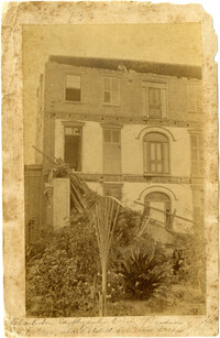
Written on reverse: 'House in which young Mr. Robson was killed. Two young ladies were buried in the ruins were rescued. Coming near Cannon.' Possibly from Cook's Earthquake Views, No.132, residence of J.N. Robson, from west. Written on front, at bottom: 'Charleston Earthquake view. Residence of Mr. J.N. Robson, whose eldest son was killed.' Charleston city directory for 1886 shows James N. Robson at 200 Coming Street.
Caption: 'Cook's Earthquake Views of Charleston and Vicinity. Taken after the 31st of August, 1886. No.131, residence J.N. Robson, south side.' Charleston city directory for 1886 shows James N. Robson at 200 Coming Street.
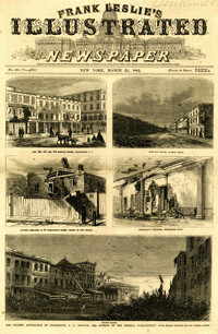
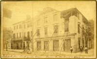
Main caption: 'The present appearance of Charleston, S.C., showing the effects of the Federal bombardment.--from recent sketches by our special artist.' Caption top left: 'Nos.165, 167 and 169 Meeting Street, Charleston, S.C.' Caption top right: 'East Bay Street, looking south.' Caption middle left: 'Kitchen attached to 53 Wentworth Street--effect of two shells.' Caption middle right: 'Gentleman's ordinary, Charleston Hotel.' Caption bottom: 'Vendue Range.' [full date March 25, 1865.]
Caption: 'Cook's Earthquake Views of Charleston and Vicinity. Taken after the 31st of August, 1886. No.134, Dr. Frazer's, Tradd Street.' Charleston city directory for 1886 shows listing for Dr. Henry D. Fraser at 139 Tradd, with offices at 137 Tradd.
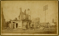
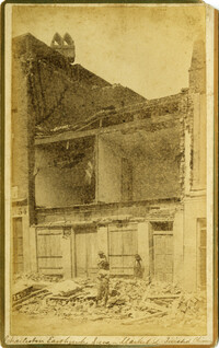
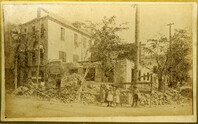
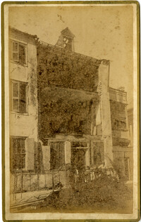
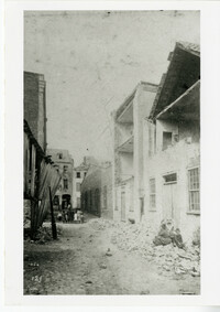
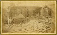
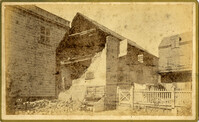
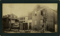
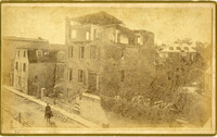
Caption: 'Cook's Earthquake Views of Charleston and Vicinity. Taken after the 31st of August, 1886. No.116, wreck in George Street.' Written on front, at bottom: 'Charleston Earthquake view - Ruins in George St.'
Caption: 'Cook's Earthquake Views of Charleston and Vicinity. Series No.2. No.182, Porch of Lazarus House.' Hassell Street. Charleston city directory for 1886 shows Mrs. B.D. Lazarus at 64 Hassell Street.
Caption: 'Cook's Earthquake Views of Charleston and Vicinity. Taken after the 31st of August, 1886. No.61, Mrs. B.D. Lazarus, Hasel [sic] St.' Charleston city directory for 1886 shows Mrs. B.D. Lazarus at 64 Hassell Street.
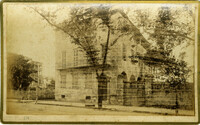
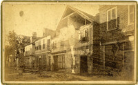
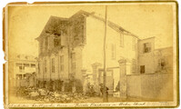
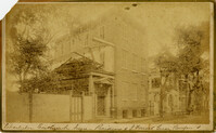
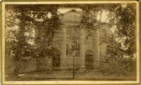
Charleston Earthquake scene. Written on front, at bottom: 'Sailor's Home, Charleston, S.C. after the Earthquake.' Sign at top of building reads: 'Charleston Port Society.'
Caption: 'Cook's Earthquake Views of Charleston and Vicinity. Taken after the 31st of August, 1886. No.70, E.B. Hume, Legare Street.' Charleston city directory for 1886 shows Errington B. Hume at 17 Legare Street.
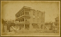
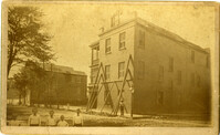
Caption: 'Cook's Earthquake Views of Charleston and Vicinity. Taken after the 31st of August, 1886. No.114, residence Col. Inglesby.' Charleston city directory for 1886 shows Charles Inglesby at 20 Meeting Street.
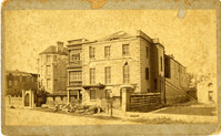
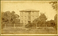
Caption: 'Cook's Earthquake Views of Charleston and Vicinity. Taken after the 31st of August, 1886. No.60, J.M. Wilson, Meeting St.' Charleston city directory for 1886 shows James M. Wilson at 39 Meeting Street.
Caption: 'Cook's Earthquake Views of Charleston and Vicinity. Taken after the 31st of August, 1886. No.78, Residence Wm. Johnson, Wentworth Street.' Charleston city directory for 1886 shows a William Johnson at 107 Wentworth Street.
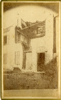
Charleston Earthquake scene. Possibly from Cook's Earthquake Views. No.68, John Kenney, Tradd Street. Charleston city directory for 1886 shows listing for John B. Kenney at 142 Tradd.
Caption: 'Cook's Earthquake Views of Charleston and Vicinity. Taken after the 31st of August, 1886. No.93, No.11 King Street.' Written on front, at bottom: 'Charleston Earthquake scene - Private residence on King St. near South Battery.'
Caption: 'Cook's Earthquake Views of Charleston and Vicinity. Series No.2. No.187, residence of Mr. A. Lengnick.' Charleston city directory for 1886 shows Albert Lengnick at 11 Pitt Street.
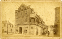
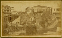
Caption: 'Cook's Earthquake Views of Charleston and Vicinity. Taken after the 31st of August, 1886. No.136, Meeting Street, cor. [of] Market.' Henry Steitz Produce is pictured. Charleston City directory for 1886 lists Henry Steitz, Fruits & Produce, at 113-115 Market Street.
Caption: 'Cook's Earthquake Views of Charleston and Vicinity. Taken after the 31st of August, 1886. No.115, Corner [of] Market and Anson Streets.' Sign on building reads: 'Ship & Family Groceries.' Written on front, at bottom: 'Charleston Earthquake view - cor. Market and Anson sts.'
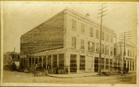
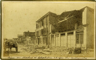
Caption: 'Cook's Earthquake Views of Charleston and Vicinity. Taken after the 31st of August, 1886. No.24, Market Street, north side.' Charleston Port Society building is pictured. Written on front, at bottom: 'View on Market St. at Charleston, S.C. after the Earthquake.'
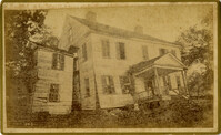
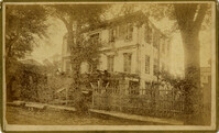
Caption: 'Cook's Earthquake Views of Charleston and Vicinity. Taken after the 31st of August, 1886. No.59, Pringle Smith, Meeting Street.' Written on front, at bottom: 'Earthquake scene Charleston, So.Ca.'
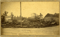
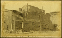
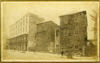
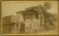
Caption: 'Cook's Earthquake Views of Charleston and Vicinity. Taken after the 31st of August, 1886. No.135, Corner State and Chalmers Streets.' Written on front, at bottom: 'Charleston Earthquake views - ruins cor[ner] Chalmers & State Str.'
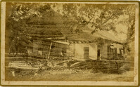
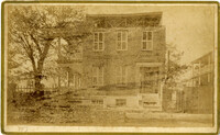
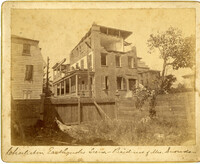
Charleston Earthquake Scene. Possibly from Cook's Earthquake Views, No.56, Alderman Murray's residence, Wentworth Street.' Charleston city directory for 1886 shows Andrew B. Murray at 175 Wentworth.


![[Elliott Street]](https://rspace.library.cofc.edu/iiif/image/50708/full/200,/0/default.jpg)