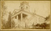
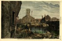
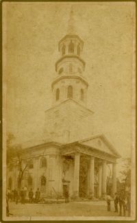
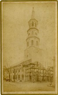
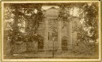
Caption: 'Cook's Earthquake Views of Charleston and Vicinity. Taken after the 31st of August, 1886. No. 17, St. Paul's Church.' St. Luke and St. Paul's Episcopal Cathedral, Coming Street.
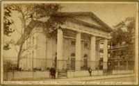
Caption: 'Cook's Earthquake Views of Charleston and Vicinity. Taken after the 31st of August, 1886. No.76, First Baptist Church, front.' Handwritten at bottom, front: 'Charleston Earthquake scene - First Baptist Church, Church Street.'
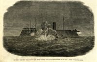
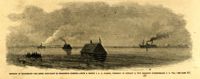
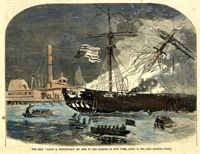
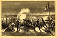
Caption in German: 'Szene auf der schwimmenden Batterie im hafen von Charleston, wahrend des Bombardments des Forts Sumter.' [Scene from the Floating Battery in Charleston Harbor, during the bombardment of Fort Sumter.]
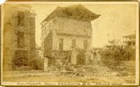
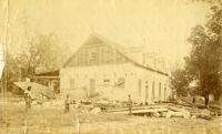
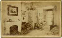
Charleston Earthquake scene. Written on front, at bottom: 'Sailor's Home, Charleston, S.C. after the Earthquake.' Sign at top of building reads: 'Charleston Port Society.'
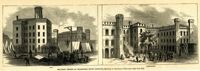
Caption: 'Military Prisons at Charleston, South Carolina.--Sketched by Lieutenant F. Milward--[See Page 110]' The Jail and Work-House are both identified.
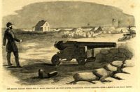
Caption: 'Caption: 'The rifled cannon which did so much execution on Fort Sumter, Charleston, South Carolina'--[From a Sketch by our Special Artist.]' [full date May 18,1861.]
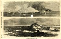
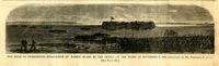
Caption: 'Siege of Charleston--1.Bombardment of Fort Moultrie and the Batteries Bee and Beauregard, by the monitors and ironsides, Sept. 7th and 8th.--2. Interior of Battery Gregg, looking towards Wagner. From sketches by our Special Artist, W.T. Crane.' [full date October 3, 1863.]
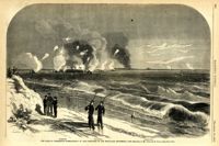
Caption: 'The Siege of Charleston--bombardment of Fort Moultrie by the iron-clads, September 8, 1863.--sketched by Mr. Theodore R. Davis.--[see page 621.] Also identified in the image: Moultrieville, Fort Moultrie and Moultrie House. [full date September 26, 1863.]
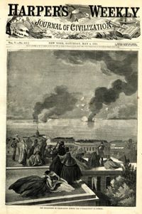
Caption: 'Night after the fight--the iron clads at anchor off Fort Sumter.--sketched by our Special Artist, Mr. W.T. Crane.--see page 81.' [full date May 2, 1863.]
Caption: 'Cook's Earthquake Views of Charleston and Vicinity. Taken after the 31st of August, 1886. No.133, 5 and 7 Broad Street.' Written on front, at bottom: 'Walker, Evans & Cogswell, Broad St.' Charleston City Directory for 1886 shows Walker, Evans & Cogswell at 3-5 Broad Street. Etiwan[Phosphate] Company is at 7 Broad.
Caption in German: 'Belagerung von Charleston.--Gen. Gillmore's hauptquartier auf Morris Island.' [Siege of Charleston.--Gen. Gillmore's headquarters on Morris Island.]
Caption: 'The siege of Charleston--View from the sea-face of Fort Wagner.--sketched by Mr. Theodore R. Davis.--[See Page 621.]' [full date September 26, 1863.]
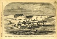
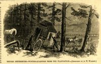
[Color image.] Caption: 'Feeding 8,000 people with rations of rice and salt at West Point Mills, on the Ashley River, Charleston S.C.-- From a sketch by our Special Artist, W.T. Crane.' [full date April 15, 1865.]
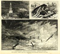
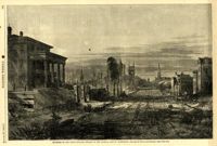
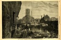
Main caption: 'South Carolina.--scenes in the track of the cyclone which devastated Charleston, August 25th. See page 43. 1. St. Michael's Church [upper left]. 2. Scene on the water front after the storm [top right]. 3. Destruction on South Battery [bottom].' [full date September 5, 1885.]
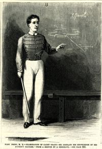
Caption: 'West Point, N.Y.--examination of Cadet Grant--he displays his knowledge of his father's battles.--from a sketch by A. Berghaus.--see page 241.' [full date June 24, 1871.]
Caption: 'Cook's Earthquake Views of Charleston and Vicinity. Taken after the 31st of August, 1886. No.21, Broad Street, south side.' Sign on building, at right, reads: 'Cigars & Tobacco' and 'W.W. Smith, 27.' Charleston city directory for 1886 lists William M. Smith, seal, stencil and stamp works, at 29 Broad Street.
Caption: 'Cook's Earthquake Views of Charleston and Vicinity. Taken after the 31st of August, 1886. No.25, Vendue Range.' Written on front, at bottom: 'Charleston Earthquake scene - Vendue Range, foot of Queen St. near the wharf.' Sign for John Werner visible. Charleston city directory for 1886 shows business at 27 Vendue Range.
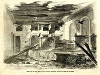
Caption: 'Quarters of the Union officers exposed to the Federal fire in Charleston.--sketched by one of the Officers.--[see page 550.]' [full date August 27, 1864.]
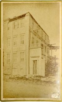
Caption: 'Cook's Earthquake Views of Charleston and Vicinity. Taken after the 31st of August, 1886. No.62, Wm. [William] Ravenel, East Battery, front.' Written on front, at bottom: 'Earthquake scene, Charleston, So.Ca. - Ravenel House'
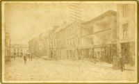
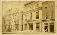
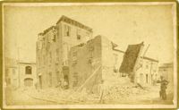
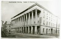
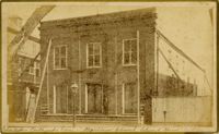
Charleston Earthquake scene. Written on front, at bottom: 'Broad St.' Image shows The News and Courier. Charleston city directory for 1886 lists it at 19 Broad Street.
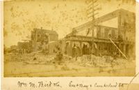
Charleston Earthquake scene. Written on front, at bottom: 'Wm M. Bird & Co. East Bay & Cumberland St.' Sign on building reads: '205, Wm. M. Bird & Co' and '203, Wm E. Holmes.'
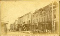
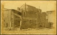
Caption: 'Cook's Earthquake Views of Charleston and Vicinity. Taken after the 31st of August, 1886. No.27, Hayne Street - ruins of three large buildings.' Sign on column at left reads: 'Charleston Bag Factory.' Charleston city directory for 1886 shows a bag factory at 15-19 Hayne Street.
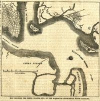
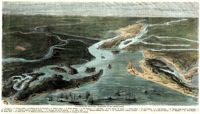
[Color image.] Caption (in French): 'Evenements des Etats-Unis: Charleston et ses fortifications. [Events of the United States: Charleston and its fortifications.] 1--Charleston. 2--Riviere Ashley [Ashley River]. 3--Chemin de fer de Savannah [Savannah Railway]. 4--Riviere Cooper [Cooper River]. 5--Riviere Wando [Wando River]. 6--Fort Pinkney [Castle Pinckney]. 7--Fort Ripley. 8--Fort Johnson (ile James) [James Island]. 9--Riviere Stone [Stono River]. 10--Fort Sumter. 11--Fort Moultrie. 12--Batterie Gregg (pointe de Gumming) [Battery Gregg (Cummings Point)]. 13--Fort Wagner. 14--Batteries rasantes du general Gilmore [grazed batteries of General Gilmore]. 15--Ouvrages pris par les federaux. [Works undertaken by the Federals]. 16--Phare Inlet [Lighthouse inlet]. 17--Batteries federales (ile Folly) [Federal Batteries (Folly Island)]. 18--Canonnieres et vaisseaux cuirasses [gunboats and ironclads]. 19--Hotel. 20--Ile et batteries Sullivan [Sullivan Island and Batteries]. 21--Moultrie. 22--Mont Pleasant [Mount Pleasant]. 23--Breach Inlet. 24--Shem Creek. 25--Batteries construite par les confederes sur l'ile James, dans le voisinage du fort Johnson [Batteries built by the Confederates on James Island, in the vicinity of Fort Johnson].
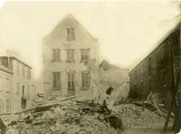
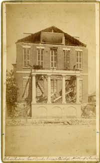
Charleston Earthquake scene. Possibly a copy of No.11 of Cook's Earthquake Views. Shows damage to the Charleston Hotel, demolished in 1960, which stood at 200 Meeting Street. 'Charleston Hotel, Hayne & Pinckney' is typewritten onto the image. Hayne and Pinckney Streets were two of the boundary streets that surrounded the hotel.
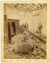
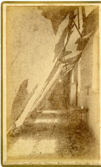
Charleston Earthquake scene. Sign at bottom of image: 'Mr. August Melm's room, 21 King Street.' Also, written on front, at bottom: 'Earthquake - Charleston S.C. 1886.' Charleston city directory for 1886 lists August Melm, a local attorney, as boarding at 21 King Street.
Caption: 'The Siege of Charleston--evacuation of Morris Island by the Rebels on the night of September 6, 1863.--sketched by Mr. Theodore R. Davis. [see page 621.]' [full date September 26, 1863.]
Caption: 'The Siege of Charleston--the attempt to blow up the ironsides, Capt. Rowan, with a torpedo, Oct. 5.--from a sketch by our Special Artist.' [full date October 31, 1863.]
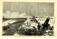
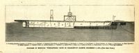
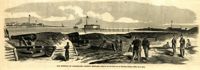
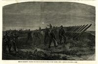
Caption: 'The new batteries erected on Morris Island for the defence of Charleston Harbor and the reduction of Fort Sumpter (sic).--from a sketch by our Special Artist in Charleston, S.C.--see page 295.' Identified with additional captions are: 1.The Iron-clad Steven's Battery on Cumming's Point. 2. Encampment on Morris Island. 3.Star of the West Battery. 4.Columbia Battery. [full date March 30, 1861.]
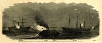
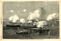
Caption: 'The War in South Carolina--the Rebel rams from Charleston Harbor attacking the Federal blockading squadron, January 31.--from a sketch by a Naval Officer.--see page 365.' Also identified in the image: Keystone State, Rebel Ram, Housatonic, Mercedita and Rebel Ram. [full date February 28, 1863.]
[Color image.] Caption (in French): 'Les troupes federales evacuant le fort Moultrie, apres avoir detruit le materiel de guerre.--D'apres les croquis de M.W.S. (Voir la Revuie de la semaine.)' [Federal troops evacuate Fort Moultrie, after destroying war materials.--from the sketch by M.W.S. (see the Review of the Week)].
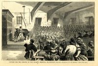
Caption: 'Concert for the inmates of the Charity Hospital, Blackwell's Island.--drawn by C.E.H. Bonwill.--(see page 150.).' [full date February 14, 1874.]
Caption: 'Defences of Charleston--the Rebel iron-clads in Charleston Harbor.--from a sketch by A.P. Palmer, formerly of Company B, 21st Regiment (Confederate) S.C. Vol.--see page 317.' [full date February 7, 1863.]
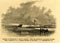
Caption: 'Defences of Charleston--"Folly's Battery," near the lighthouse, Charleston Harbor. From a sketch by A.P. Palmer, Company B, 21st Regt., S.C. (Confederate) Vol.' [full date February 7, 1863.]
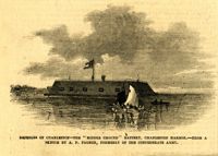
Caption: 'Defences of Charleston--the "Middle Ground" Battery, Charleston Harbor.--from a sketch by A.P. Palmer, formerly of the Confederate Army.' [full date February 7, 1863.]
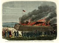
[Color image]. Caption: 'The ship "Jacob A. Wetervelt" on fire in the harbor of New York, April 11, 1860.--[see preceding page.]' [full date April 21, 1860.]
Caption: 'Cook's Earthquake Views of Charleston and Vicinity. Taken after the 31st of August, 1886. No.115, Corner [of] Market and Anson Streets.' Sign on building reads: 'Ship & Family Groceries.' Written on front, at bottom: 'Charleston Earthquake view - cor. Market and Anson sts.'
Charleston Earthquake scene. Written on reverse: 'East Battery, just below Atlantic Street. Edmonston [sic] House, later the Charles Alston residence. Now (1947) the residence of J.J. Pringle Smith. Old Holmes house on left. Earthquake of 1886 - Charleston, S.C.'
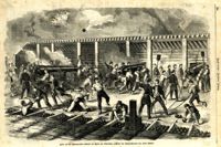
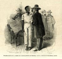
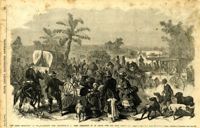
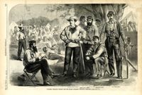
Caption: '"The Grand Skedaddle" of the inhabitants from Charleston, S.C., when threatened by an attack from the Union troops.--from a sketch by Lieut. G.P. Kirby, 47th N.Y.V., when a prisoner in Charleston.--see page 270.' [full date January 17, 1863.]
Caption: 'Colonel William Wilson and his staff (Wilson's Fighting Brigade)--[see page 311].' Identified in image: Quartermaster Bradley, Lieutenant Colonel Creighton, Adjutant James J. Hearey, Paymaster Peter Duffy, Col. William Wilson, Surgeon D.C. Pease. [full date May 18, 1861.]
Caption: 'Firing on the "Star of the West" from the South Carolina battery on Morris Island, January 10, 1861.--[see page 54.]' [full date January 26, 1861]
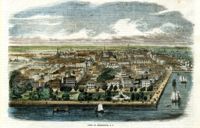
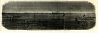
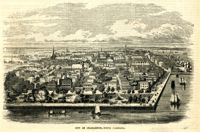
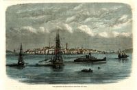
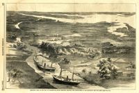
Caption: 'Birds-eye view of the city of Charleston, South Carolina, showing the approaches of our gun-boats and our army.--[see page 431.]' [full date July 5, 1862.]
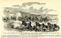
Caption: 'Captain Knapp's Battery engaging the Confederates at the Battle of Cedar Mountain, August 9th, 1862--this battery fired the first and last shot.'
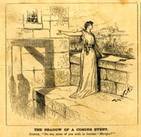
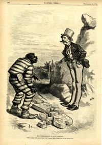
Political cartoon, caption: 'The Commandments in South Carolina. "We've pretty well smashed that; but I suppose, Massa Moses, you can get another one."' [full date September 26, 1874]
Caption: 'Siege of Charleston--planting the chevaux de frise in front of Fort Wagner.--from a sketch by our Special Artist.' [full date September 26, 1863.]
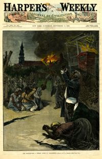
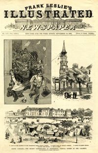
Caption: 'South Carolina.--The recent earthquakes at Charleston--typical scenes of the calamity. From sketches by C. Upham--see page 71. 1. Scene on the stairway of the Charleston Hotel during a shock. 2. Taking down St. Philip's Steeple. 3. Scene on Marion Square, opposite the Citadel--a city of tents.' [full date September 18, 1886.]
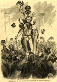
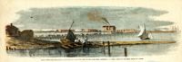
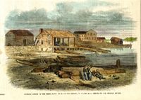
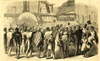
Caption: 'Enthusiastic crowd of citizens of Charleston, S.C., assembled on Vanderhost's (sic) Wharf, Feb. 20, to greet the second visit of Gen. Gillmore and staff.--sketched by our Special Artist.' [full date March 25, 1865.]
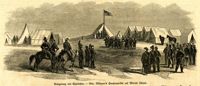
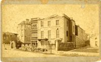
Caption: 'Cook's Earthquake Views of Charleston and Vicinity. Taken after the 31st of August, 1886. No.40, Bishop's house, Broad Street.' Handwritten at bottom, front: 'Charleston Earthquake scene - Bishop Northrup's Residence.' Charleston city directory for 1886 shows Bishop Henry P. Northrop at 114 Broad Street.
Caption: 'Cook's Earthquake Views of Charleston and Vicinity. Taken after the 31st of August, 1886. No.150, Mariner's Church, exterior." Also, handwritten at bottom of image: 'Charleston Earthquake scene - Mariners' Church, Church Street ? East Bay'