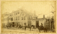
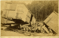
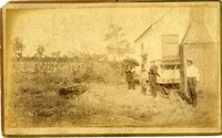
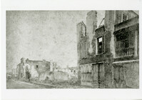
Caption: 'Cook's Earthquake Views of Charleston and Vicinity. Taken after the 31st of August, 1886. No.116, wreck in George Street.' Written on front, at bottom: 'Charleston Earthquake view - Ruins in George St.'
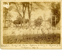
Caption: 'Charleston Earthquake. Photographs by Dr. E.P. Howland, taken on his visit to Charleston and the earthquake region of Ten Mile Hill and Summerville. Over 150 photographs were taken. Orphans and tents in which they lived.' Written on front, at bottom: 'Charleston Earthquake scene - orphans, standing the yard of the Orphan House.'
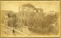
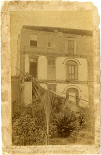
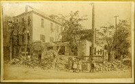
Written on reverse: 'House in which young Mr. Robson was killed. Two young ladies were buried in the ruins were rescued. Coming near Cannon.' Possibly from Cook's Earthquake Views, No.132, residence of J.N. Robson, from west. Written on front, at bottom: 'Charleston Earthquake view. Residence of Mr. J.N. Robson, whose eldest son was killed.' Charleston city directory for 1886 shows James N. Robson at 200 Coming Street.
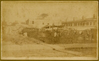
Caption: 'Cook's Earthquake Views of Charleston and Vicinity. Taken after the 31st of August, 1886. No.149, Robb's Lot.' Handwritten on reverse: ' Robb's Lot E. side [of] King bet[ween] Market & Horlbeck.'
Caption: 'Colonel William Wilson and his staff (Wilson's Fighting Brigade)--[see page 311].' Identified in image: Quartermaster Bradley, Lieutenant Colonel Creighton, Adjutant James J. Hearey, Paymaster Peter Duffy, Col. William Wilson, Surgeon D.C. Pease and Major William Newby. [full date May 18, 1861.]
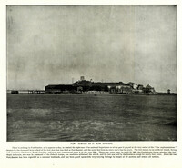
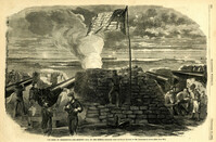
Caption: 'Reinforcement of Fort Pickens by Company A, First Artillery, on Saturday morning, April 13--Sketched by an Engineer Officer of the "Brooklyn."--[See Next Page].' [full date May 18,1861.]
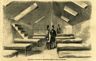
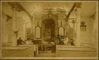
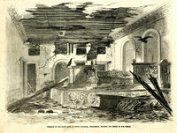
Caption (in German): 'Das Innere des Hospitals der schwimmenden Batterie im hafen von Charleston.' {Interior of the hospital of the Floating Battery in Charleston Harbor}
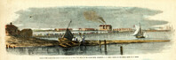
Caption: 'The Battery or Park Promenade at Charleston, South Carolina, during the bombardment of Fort Sumter--Sketched by our Special Artist--[see next page].' [full date May 18, 1861.]
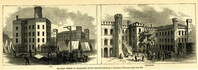
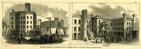
Caption: 'Military Prisons at Charleston, South Carolina.--Sketched by Lieutenant F. Milward--[See Page 110]' The Jail and Work-House are both identified.
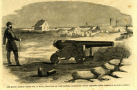
Caption: 'Caption: 'The rifled cannon which did so much execution on Fort Sumter, Charleston, South Carolina'--[From a Sketch by our Special Artist.]' [full date May 18,1861.]
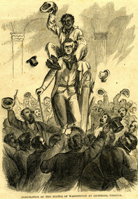
Caption: 'A detachment of the First South Carolina (Colored) Federal Volunteers, Colonel Beard, repelling an attack of the Confederate troops in the vicinity of Doboy River, Ga. From a sketch by Colonel Brewerton.'
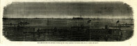
Caption: 'Morris Island, as seen from Fort Sumter.--[drawn by an Officer of Major Anderson's Command.]' Also identified with captions: 'Battery from which the "Star of the West" was fired upon. Cumming's Point. Sand Battery, connected by covered gallery with...iron-clad battery.' [full date March 2, 1861.]
Caption: 'Remains of the new bridge over Ashley River, Charleston, S.C., partially destroyed by the Rebels on the evacuation of the city, Feb 18, 1865.--from a sketch by our Special Artist, W.T. Crane.' [full date June 10, 1865.]
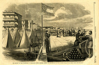
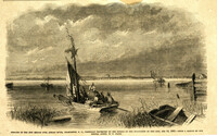
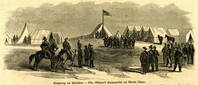
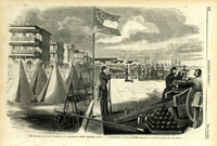
Caption: 'The Richland Rifles enjoying the "after-dinner hour," at their quarters on Sullivan's Island, Charleston Harbor, S.C. From a sketch taken on the spot by our Special Artist now in Charleston.' [full date March 2, 1861.]
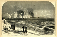
Caption: 'Siege of Charleston--1.Bombardment of Fort Moultrie and the Batteries Bee and Beauregard, by the monitors and ironsides, Sept. 7th and 8th.--2. Interior of Battery Gregg, looking towards Wagner. From sketches by our Special Artist, W.T. Crane.' [full date October 3, 1863.]
Caption: 'The Siege of Charleston--bombardment of Fort Moultrie by the iron-clads, September 8, 1863.--sketched by Mr. Theodore R. Davis.--[see page 621.] Also identified in the image: Moultrieville, Fort Moultrie and Moultrie House. [full date September 26, 1863.]
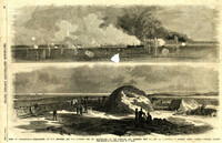
Caption: 'Night after the fight--the iron clads at anchor off Fort Sumter.--sketched by our Special Artist, Mr. W.T. Crane.--see page 81.' [full date May 2, 1863.]
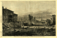
Main caption: 'The present appearance of Charleston, S.C., showing the effects of the Federal bombardment.--from recent sketches by our special artist.' Caption top left: 'Nos.165, 167 and 169 Meeting Street, Charleston, S.C.' Caption top right: 'East Bay Street, looking south.' Caption middle left: 'Kitchen attached to 53 Wentworth Street--effect of two shells.' Caption middle right: 'Gentleman's ordinary, Charleston Hotel.' Caption bottom: 'Vendue Range.' [full date March 25, 1865.]
Caption: 'The siege of Charleston--View from the sea-face of Fort Wagner.--sketched by Mr. Theodore R. Davis.--[See Page 621.]' [full date September 26, 1863.]
Caption: 'Sketches in Charleston, South Carolina. 1.Cotton Day. 2. A Limb of the Law. 3. Gossips. 4.Light-wood cart. 5. "A Relic". 6. Milk Girl.7. In the Market-Poultry Dealer. 8."Horse" Car.' [full date July 17, 1875.]
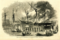
Caption: 'Scene on the Floating Battery in Charleston Harbor, S.C., during the bombardment of Fort Sumpter (sic).--from a sketch by an Officer.--see page 355.' [full date April 27, 1861.]
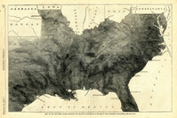
Caption: 'Map of the Southern states, showing the relative proportion of slaves in the different localities.--[see page 142.]' [full date February 28, 1863.]
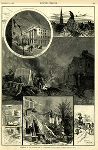
Main caption: 'Incidents of the Earthquake at Charleston.--drawn by Schell and Hogan.--[see page 590.]' Caption top left: 'In front of the Charleston Hotel.' Caption top right: 'looking over the roofs.' Caption middle: 'A camp on the East Battery.' Caption bottom left: 'The front wall gone.' Caption bottom center: 'In a rich man's garden.' Caption bottom right: ' On the track.' [full date September 11, 1886.]
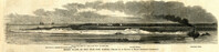
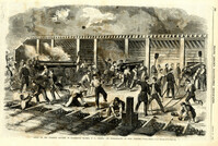
Caption: 'General Halleck's fleet of mortar-boats for service on the Mississippi.--sketched by Mr. Alexander Simplot.--[see page 827.]' [full date December 28, 1861.]
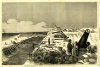
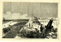
Caption: 'Folley's (sic) Battery, near the lighthouse, at Charleston, South Carolina.--from a sketch by A.P. Palmer, 21st South Carolina Volunteers.--[see page 79.]' [full date January 31, 1863.]
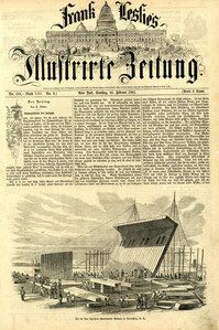
Caption (in German): 'Die im Ban [Bau] begriffene schwimmende Batterie in Charleston, S.C.' [The nascent Floating Battery in Charleston, S.C.] [full date February 16, 1861.]
Caption: 'Military Prisons at Charleston, South Carolina.--Sketched by Lieutenant F. Milward--[See Page 110]' the Jail and Work-House are both identified. [full date February 18, 1865.]
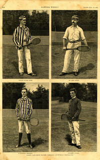
Main caption: 'Leading lawn-tennis players.--photographed by E.M. Bidwell.--[see page 583.]' Caption top left: 'Richard Dudley Sears.' Caption top right: 'Dr. James Dwight.' Caption bottom left: 'R. Livingston Beeckman.' Caption bottom right: 'Howard A. Taylor.' [full date September 11, 1886.]
Caption: 'Cook's Earthquake Views of Charleston and Vicinity. Taken after the 31st of August, 1886. No.125, Scene near Atlantic Wharf.' Charleston city directory for 1886 lists Atlantic Wharf at the rear of the Post Office.
Caption: 'Cook's Earthquake Views of Charleston and Vicinity. Taken after the 31st of August, 1886. No.82, East Bay Street.' Sign for Jas [James] Ackermann at 114 East Bay is visible.
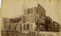
Caption: 'Cook's Earthquake Views of Charleston and Vicinity. Taken after the 31st of August, 1886. No.133, 5 and 7 Broad Street.' Written on front, at bottom: 'Walker, Evans & Cogswell, Broad St.' Charleston City Directory for 1886 shows Walker, Evans & Cogswell at 3-5 Broad Street. Etiwan[Phosphate] Company is at 7 Broad.
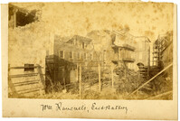
Charleston Earthquake scene. Possibly from Cook's Earthquake Views, no.63. William Ravenel, East Battery, rear. Written on front, at bottom: 'Wm Ravenel's, East Battery.'
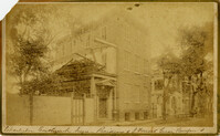
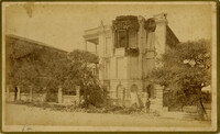
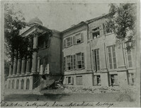
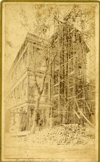
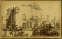
Caption: 'Cook's Earthquake Views of Charleston and Vicinity. Taken after the 31st of August, 1886. No.129, College as torn down.' Handwritten at bottom, front: 'Charleston Earthquake views - Charleston College. Both wings gone.'
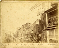
Caption: 'Cook's Earthquake Views of Charleston and Vicinity. Series No.2. No.181, Beresford Street.' This may be Beresford Alley which is also known as Clifford Street.
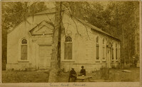
Caption: 'Cook's Earthquake Views of Charleston and Vicinity. Taken after the 31st of August, 1886.' Possibly No.178, but corresponding captioning is missing. Handwritten on reverse: 'Formerly St. Luke's Episcopal now [New Tabernacle] Fourth Baptist Church, 22 Elizabeth Street.' Handwritten at bottom, front: 'Charleston Earthquake scene - St. Luke's Episcopal Church.'
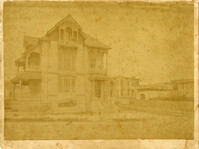
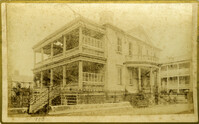
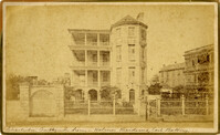
Caption: 'Cook's Earthquake Views of Charleston and Vicinity. Taken after the 31st of August, 1886. No.65, _____ Holmes, East Battery.' Written on front, at bottom: 'Charleston Earthquake scene - Holmes residence, East Battery.' Charleston city directory for 1886 shows Charles R. Holmes, Jr., at 19 East Battery.
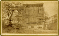
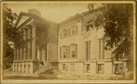
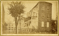
Caption: 'Cook's Earthquake Views of Charleston and Vicinity. Series No.2. No.170, Buist residence, Rutledge Street.' Written on front, at bottom: Buist Residence, 43 Rutledge St.' Charleston city directory for 1886 shows listing for Samuel S. Buist at 43 Rutledge Avenue.
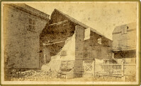
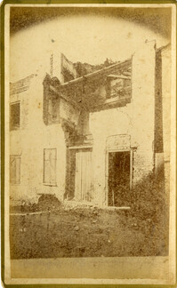
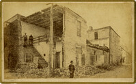
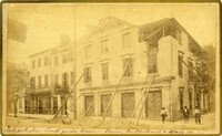
Caption: 'Cook's Earthquake Views of Charleston and Vicinity. Taken after the 31st of August, 1886. No.135, Corner State and Chalmers Streets.' Written on front, at bottom: 'Charleston Earthquake views - ruins cor[ner] Chalmers & State Str.'
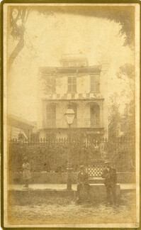
Caption: 'Cook's Earthquake Views of Charleston and Vicinity. Series No.2. No.187, residence of Mr. A. Lengnick.' Charleston city directory for 1886 shows Albert Lengnick at 11 Pitt Street.
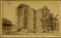
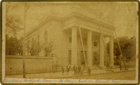
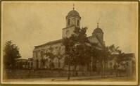
Caption: 'Cook's Earthquake Views of Charleston and Vicinity. Taken after the 31st of August, 1886. No.99, Rear of Scotch Church.' Handwritten at bottom, front: 'Charleston Earthquake scene - Rear of First Presbyterian Church.'
Caption: 'Cook's Earthquake Views of Charleston and Vicinity. Taken after the 31st of August, 1886. No.99, Rear of Scotch Church.' First (Scots) Presbyterian Church on Meeting Street.
Caption: 'Cook's Earthquake Views of Charleston and Vicinity. Taken after the 31st of August, 1886. No.79, St. Mary's Church. [And handwritten] Hasell Street.'
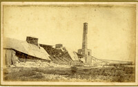
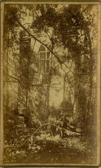
Caption: 'Cook's Earthquake Views of Charleston and Vicinity. Taken after the 31st of August, 1886. No.148, Landslide on the Ashley.' Handwritten at bottom, front: 'Charleston Earthquake view - Land slide near Summerville, S.C.'
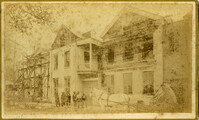
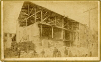
Charleston Earthquake scene. Possibly from Cook's Earthquake Views. Series No.2. No.169, College of Charleston, front [captioning missing, 'Cook No.169' handwritten on reverse].
Caption: 'Quarters of the Union officers exposed to the Federal fire in Charleston.--sketched by one of the Officers.--[see page 550.]' [full date August 27, 1864.]
Caption: 'The Siege of Charleston--the morning call to the Rebels.--sketched from the naval battery by Mr. Theodore R. Davis.--[see page 603.]' [full date September 19, 1863.]
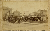
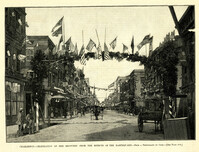
Caption: 'Charleston--Celebration of her recovery from the effects of the Earthquake.--from a photograph by Cook.--[see page 818.]' [full date November 12, 1887.]
Caption in German: 'Belagerung von Charleston.--Gen. Gillmore's hauptquartier auf Morris Island.' [Siege of Charleston.--Gen. Gillmore's headquarters on Morris Island.]
Caption: 'The siege of Charleston--View from the sea-face of Fort Wagner.--sketched by Mr. Theodore R. Davis.--[See Page 621.]' [full date September 26, 1863.]
[Color image.] Caption: 'Feeding 8,000 people with rations of rice and salt at West Point Mills, on the Ashley River, Charleston S.C.-- From a sketch by our Special Artist, W.T. Crane.' [full date April 15, 1865.]
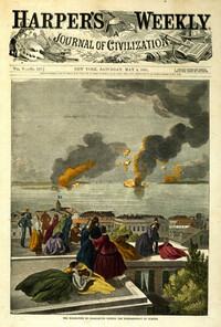
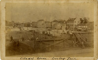
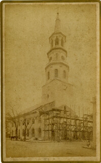
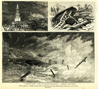
Main caption: 'South Carolina.--scenes in the track of the cyclone which devastated Charleston, August 25th. See page 43. 1. St. Michael's Church [upper left]. 2. Scene on the water front after the storm [top right]. 3. Destruction on South Battery [bottom].' [full date September 5, 1885.]
Caption: 'The Battery or Park Promenade at Charleston, South Carolina, during the bombardment of Fort Sumter--Sketched by our Special Artist--[see next page].' [full date May 18, 1861.]
Caption: 'Cook's Earthquake Views of Charleston and Vicinity. Series No.2. No.167, rear of residence of Geo. [George] W. Williams, Jr.' Charleston city directory for 1886 shows George W. Williams, Jr. at 2 Atlantic Street.