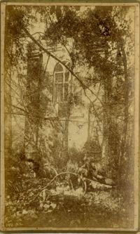
Caption: 'Cook's Earthquake Views of Charleston and Vicinity. Taken after the 31st of August, 1886. [Marked as] No.16, First Presbyterian Church [and] No.99, Rear of Scotch Church.' Handwritten at bottom, front: 'Charleston Earthquake scene - First Presbyterian Church - side and rear view.'
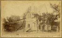
Caption: 'Cook's Earthquake Views of Charleston and Vicinity. Taken after the 31st of August, 1886. No.117, Citadel Square Baptist Church.' Also, handwritten at bottom, front: 'Charleston Earthquake scene - Citadel Square Baptist Church.'
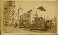
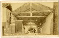
Caption: 'Cook's Earthquake Views of Charleston and Vicinity. Taken after the 31st of August, 1886. No.4, Roper Hospital.' Shows Roper Hospital when at Queen Street location.
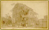
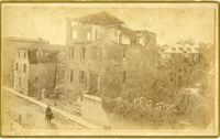
Caption: 'Cook's Earthquake Views of Charleston and Vicinity. Taken after the 31st of August, 1886. No.134, Dr. Frazer's, Tradd Street.' Charleston city directory for 1886 shows listing for Dr. Henry D. Fraser at 139 Tradd, with offices at 137 Tradd.
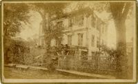
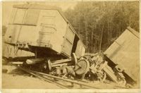
Caption: 'Charleston Earthquake. Photographs by Dr. E.P. Howland, taken on his visit to Charleston and the earthquake region of Ten Mile Hill and Summervile. Over 150 Photographs were taken. House of Mr. Ravenell [sic], President Northeastern R.R.'
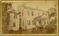
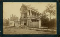
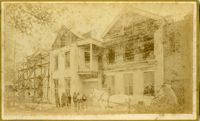
Caption: 'Cook's Earthquake Views of Charleston and Vicinity. Taken after the 31st of August, 1886. No.78, Residence Wm. Johnson, Wentworth Street.' Charleston city directory for 1886 shows a William Johnson at 107 Wentworth Street.
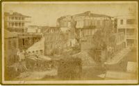
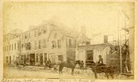
Charleston Earthquake scene. Written on front, at bottom: 'Commercial Cotton Press, East Bay.' Charleston city directory for 1886 lists Commercial Wharf and Cotton Press, Co. on East Bay Street and Longitude Lane.
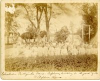
Caption: 'Charleston Earthquake. Photographs by Dr. E.P. Howland, taken on his visit to Charleston and the earthquake region of Ten Mile Hill and Summerville. Over 150 photographs were taken. Orphans and tents in which they lived.' Written on front, at bottom: 'Charleston Earthquake scene - orphans, standing the yard of the Orphan House.'
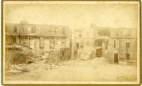
Caption: 'Cook's Earthquake Views of Charleston and Vicinity. Taken after the 31st of August, 1886. No.116, wreck in George Street.' Written on front, at bottom: 'Charleston Earthquake view - Ruins in George St.'
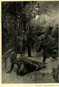
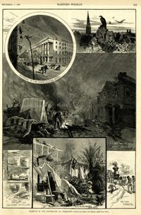
Main caption: 'Incidents of the Earthquake at Charleston.--drawn by Schell and Hogan.--[see page 590.]' Caption top left: 'In front of the Charleston Hotel.' Caption top right: 'looking over the roofs.' Caption middle: 'A camp on the East Battery.' Caption bottom left: 'The front wall gone.' Caption bottom center: 'In a rich man's garden.' Caption bottom right: ' On the track.' [full date September 11, 1886.]
Caption: 'Cook's Earthquake Views of Charleston and Vicinity. Series No.2. No.181, Beresford Street.' This may be Beresford Alley which is also known as Clifford Street.