Oakland Plantation (Youghall Plantation), 1164 Porcher Bluff Road. Smoke House - View of NE (Front and Side) elevation. Mount Pleasant, S.C.;6.5" x 10" B/W photo. Box 10, Folder 2-2-10. One copy.
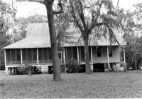
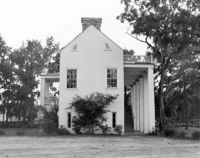
Isaac Porcher House - Main House. View of North (Front) elevation. Pinopolis Historic District North. Pinopolis, S.C.;6.5" x 9.5" B/W photo. Box 4, Folder 1-10-1 (III). Two copies.
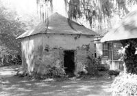
Dean Hall Plantation - Overseers House. View of North (Side) elevation. Oakley, SC. NOTE: Property relocated to Moncks Corner, S.C.;8" x 10" B/W photo. Box 2, Folder 1-8-9. One copy.
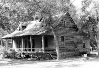
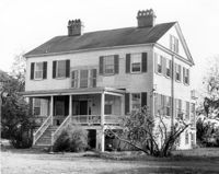
Windsor Plantation (Little Edisto Plantation, Ashwood Plantation), S.C. Hwy. 174. View of SE (Rear and Side) elevation. Edisto Island, S.C.;8" x 10" B/W photo. Box 11, Folder 2-3-18. One copy.
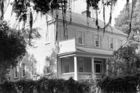
McLeod Plantation, 325 Country Club Drive. Main House - View of NE (Rear and Side) elevation. Charleston, S.C.;6.5" x 10" B/W photo. Box 12, Folder 2-4-5. One copy.
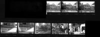
Old Carroll House (Carroll Place), Junction of Quaker and Wire Roads. Contact Sheet 13 - Multiple Views. St. George, S.C.;10" x 4" B/W photo. Box 20, Folder: Miscellaneous Photos: Scanned Contact Sheets. One copy.
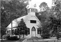
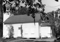
Church of the Redeemer (Pineville Chapel), Matilda Circle. View of SE (Side and Rear) elevation. Pineville Historic District. Pineville, SC.;6.5" x 9.5" B/W photo. Box 3, Folder 1-9-1 (I). One copy.