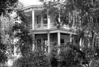
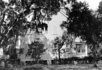
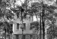
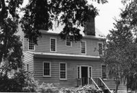
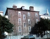
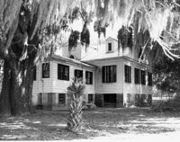
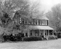
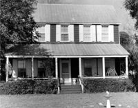
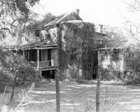
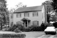
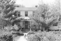
Stiles Point Plantation (Stiles-Hinson-Thompson House), 940 Paul Revere Drive. View of NE (Front and Side) elevation. Charleston S.C.;6.5" x 10" B/W photo. Box 12, Folder 2-4-7. One copy.
Stiles Point Plantation (Stiles-Hinson-Thompson House), 940 Paul Revere Drive. View of North (Front) elevation. Charleston S.C.;6.5" x 10" B/W photo. Box 12, Folder 2-4-7. One copy.
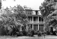
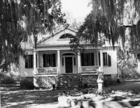
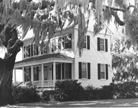
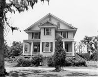
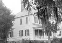
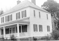
McLeod Plantation, 325 Country Club Drive. Main House - View of South (Front) elevation. Charleston, S.C.;6.5" x 10" B/W photo. Box 12, Folder 2-4-5. One copy.
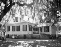
McLeod Plantation, 325 Country Club Drive. Main House - View of East (Side) elevation. Charleston, S.C.;8" x 10" B/W photo. Box 12, Folder 2-4-5. One copy.
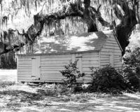
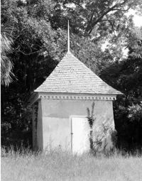
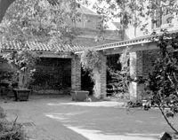
McLeod Plantation, 325 Country Club Drive. Kitchen Building - View of NW (Front and Side) elevation. Charleston, S.C.;8" x 10" B/W photo. Box 12, Folder 2-4-5. One copy.
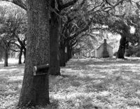
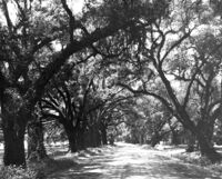
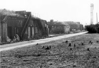
McLeod Plantation, 325 Country Club Drive. Slave Cabins Avenue - View of West (Side) elevation. Charleston, S.C.;8" x 10" B/W photo. Box 12, Folder 2-4-5. One copy.
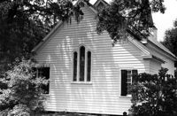
Shaw Community Center, 22 Mary Street. Main Building - View of South (Rear) elevation, looking West. Charleston, S.C. (NOTE: Structure demolished in 1974);8.25" x 7.5" B/W photo. Box 6, Folder 2-1-13. One copy.
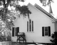
Christ Church Episcopal - Adams Run, State Highway 174. View of East (Rear) elevation. Hollywood, S.C.;6.5" x 10" B/W photo. Box 16, Folder 2-11-12. Three copies.
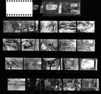
Peachtree Plantation, Located along the South Santee River. Contact Sheet 10 - Multiple Views. McClellenville, S.C.;10" x 8" B/W photo. Box 20, Folder: Miscellaneous Photos: Scanned Contact Sheets. One copy.
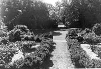
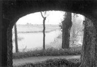
Harrietta Plantation, 7 Mile Road. View of Garden (from Front Porch). North elevation. McClellanville, S.C.;6.5" x 10" B/W photo. Box 14, Folder 2-10-2. One copy.
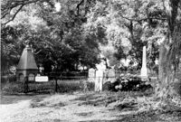
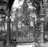
Magnolia Cemetery, Huguenin Avenue and Algonquin Road. Tombstone of Birt family. View of Front elevation. NOTE: Print has superimposed second image. Charleston, S.C.;8" x 8" B/W photo. Box 5, Folder 2-1-3. Two copies.
Rockville Historic District - Grace Episcopal Chapel (Grace Epsicopal Church), Grace Chapel Road. View of Front and Side elevation. Wadmalaw, S.C.;10" x 6.5" (and 10" x 8") B/W photo. Box 17, Folder 2-14-18. Two copies.
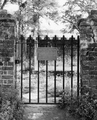
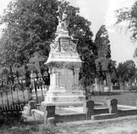
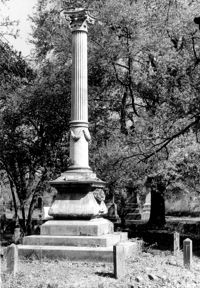
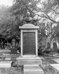
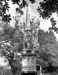
Magnolia Cemetery, Huguenin Avenue and Algonquin Road. Monument of Hugh Swinton Legare. View of Front and Side elevation. Charleston, S.C.;10" x 6.5" B/W photo. Box 5, Folder 2-1-3. One copy.
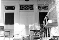
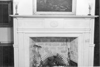
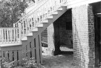
San Souci House, 206 San Souci Street. Detail View of Front Stairs. SW (Front and Side) elevation. Charleston, S.C.;6.5" x 10" B/W photo. Box 8, Folder 2-1-149. One copy.
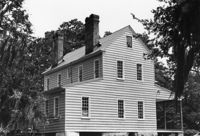
Marshlands Plantation, Fort Sumter Drive. Main House - View of North (Rear) elevation. James Island, S.C.;6.5" x 10" (and 3" x 5") B/W photo. Box 11, Folder 2-4-3. Two copies.
Marshlands Plantation, Fort Sumter Drive. Main House - View of East (Side) elevation. James Island, S.C.;6.5" x 10" (and 3" x 5") B/W photo. Box 11, Folder 2-4-3. Two copies.
Battery Gadsden (Charleston County Public Library, Edgar Allen Poe Branch), 1921 I'on Avenue. View of East Wing and 2nd Gun Platform from East end, NW (Front and Side) elevation. Sullivans Island, S.C.;6.5" x 10" B/W photo. Box 16, Folder 2-13-6. One copy.
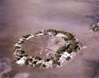
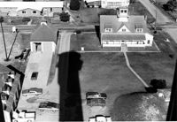
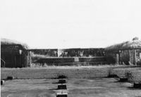
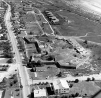
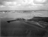
U.S. Coast Guard Historical District, I'on Avenue. Aerial View - South elevation. Sullivans Island, S.C.;6.5" x 10" (and 3.5" x 5") B/W photo. Box 16, Folder 2-13-1. Two copies.
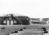
Battery Gadsden (Charleston County Public Library, Edgar Allen Poe Branch), 1921 I'on Avenue. View of East Wing and 2nd Gun Platform from East end, North (Front) elevation. Sullivans Island, S.C.;6.5" x 10" B/W photo. Box 16, Folder 2-13-6. One copy.
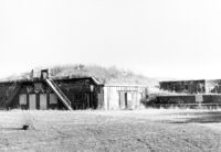
Battery Gadsden (Charleston County Public Library, Edgar Allen Poe Branch), 1921 I'on Avenue. View of all three Wings, NW (Side and Front) elevation - looking East. Sullivans Island, S.C.;6.5" x 10" B/W photo. Box 16, Folder 2-13-6. One copy.
Battery Gadsden (Charleston County Public Library, Edgar Allen Poe Branch), 1921 I'on Avenue. View of 2nd Gun Platform from East end, North (Front) elevation. Sullivans Island, S.C.;6.5" x 10" B/W photo. Box 16, Folder 2-13-6. One copy.
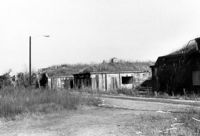
Battery Gadsden (Charleston County Public Library, Edgar Allen Poe Branch), 1921 I'on Avenue. View of West Wing and 4th Gun Platform from East end, South (Rear) elevation. Sullivans Island, S.C.;6.5" x 10" B/W photo. Box 16, Folder 2-13-6. One copy.
Battery Gadsden (Charleston County Public Library, Edgar Allen Poe Branch), 1921 I'on Avenue. View of 4th Gun Platform from East end? West, (Side) elevation. Sullivans Island, S.C.;6.5" x 10" B/W photo. Box 16, Folder 2-13-6. One copy.
Battery Gadsden (Charleston County Public Library, Edgar Allen Poe Branch), 1921 I'on Avenue. View of East Wing, North (Front) elevation - looking West. Sullivans Island, S.C.;6.5" x 10" B/W photo. Box 16, Folder 2-13-6. One copy.
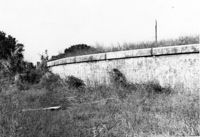
Battery Gadsden (Charleston County Public Library, Edgar Allen Poe Branch), 1921 I'on Avenue. View of Retaining Wall around Glacis, West elevation. Sullivans Island, S.C.;6.5" x 10" B/W photo. Box 16, Folder 2-13-6. One copy.
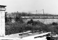
Battery Gadsden (Charleston County Public Library, Edgar Allen Poe Branch), 1921 I'on Avenue. View of Retaining Wall around Glacis, South elevation. Sullivans Island, S.C.;6.5" x 10" B/W photo. Box 16, Folder 2-13-6. One copy.
Battery Gadsden (Charleston County Public Library, Edgar Allen Poe Branch), 1921 I'on Avenue. View of Retaining Wall around Glacis, South elevation. Sullivans Island, S.C.;6.5" x 10" B/W photo. Box 16, Folder 2-13-6. One copy.
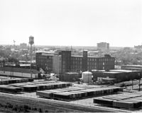
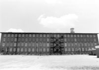
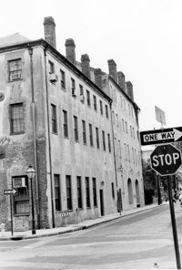
Cigar Factory, 701 East Bay Street. General View of NE (Front and Side) elevation. Charleston, S.C.;8" x 10" B/W photo. Box 9, Folder 2-1-221. One copy.
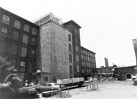
Cigar Factory, 701 East Bay Street. View of East (Front) elevation, looking North. Charleston, S.C.;7" x 10" B/W photo. Box 9, Folder 2-1-221. One copy.
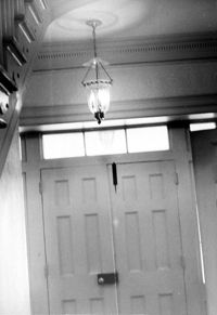
The Grove Plantation (Ernest F. Hollings ACE Basin National Wildlife Refuge). Interior View - 1st Floor. Detail of Front Door. Adams Run, S.C.;10" x 6.5" B/W photo. Box 15, Folder 2-11-1. One copy.
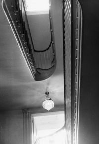
The Grove Plantation (Ernest F. Hollings ACE Basin National Wildlife Refuge). Interior View - 1st Floor. Detail of Stairwell. Adams Run, S.C.;10" x 6.5" B/W photo. Box 15, Folder 2-11-1. One copy.
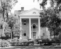
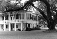
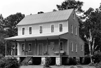
The Grove Plantation (Ernest F. Hollings ACE Basin National Wildlife Refuge). View of SE (Front and Side) elevation. Adams Run, S.C.;6.5" x 10" B/W photo. Box 15, Folder 2-11-1. Three copies.
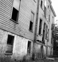
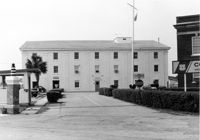
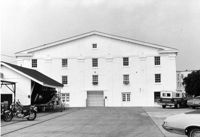
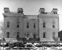
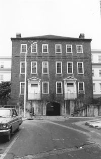
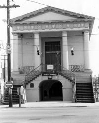
Old Citadel (South Carolina State Arsenal, Embassy Suites Hotel), 337 Meeting Street. View of North (Rear) elevation. Charleston, S.C.;8" x 10" B/W photo. Box 5, Folder 2-1-5. One copy.
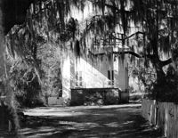
Barnwell House (Prospect Hill Plantation), Sugar Hill Road. View of East (Side) elevation. Hollywood, S.C.;8" x 10" B/W photo. Box 16, Folder 2-11-5. One copy.
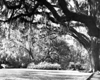
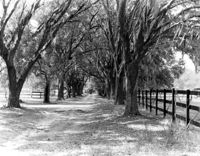
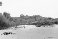
Wedge Plantation (William Lucas House), Wedge Plantation Road. View of Oak Allee. McClellanville, S.C.;8" x 10" B/W photo. Box 15, Folder 2-10-6. One copy.
Magnolia Cemetery, Huguenin Avenue and Algonquin Road. Monument of William Ashmead Courtenay. View of Front elevation. Charleston, S.C.;10" x 8" B/W photo. Box 5, Folder 2-1-3. One copy.
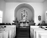
Christ Church Episcopal - Adams Run, State Highway 174. View of Interior. West (Front) elevation. Hollywood, S.C.;8" x 10" B/W photo. Box 16, Folder 2-11-12. One copy.
Christ Church Episcopal - Adams Run, State Highway 174. View of East (Rear) elevation. Hollywood, S.C.;8" x 10" B/W photo. Box 16, Folder 2-11-12. One copy.
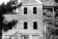
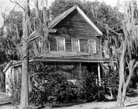
Old House Plantation, Clark Road. Main House - View of SE (Side and Rear) elevation. Edisto Island, S.C.;8" x 10" B/W photo. Box 11, Folder 2-3-10. One copy.
Bleak Hall Plantation, S.C. Hwy. 174. Smoke House - View of SW (Front) elevation. Edisto Island, S.C.;10" x 8" B/W photo. Box 10, Folder 2-3-2. One copy.
Old House Plantation, Clark Road. Main House - View of North (Front) elevation. Edisto Island, S.C.;8" x 10" B/W photo. Box 11, Folder 2-3-10. One copy.
Magnolia Cemetery, Huguenin Avenue and Algonquin Road. Monument of Sarah F., Charles F., and Elbert P. Jones. View of North elevation. Charleston, S.C.;10" x 8" B/W photo. Box 5, Folder 2-1-3. One copy.
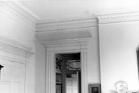
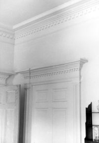
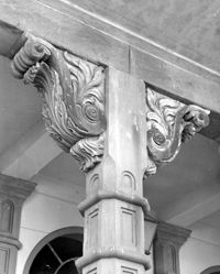
Dock Street Theater, 135 Church Street. Detail View of Porch Column. West (Front) elevation. Charleston, S.C.;10" x 8" B/W photo. Box 6, Folder 2-1-32. One copy.
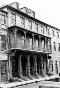
Dock Street Theater, 135 Church Street. View of NW (Front) elevation, looking West. Charleston, S.C.;10" x 6.5" B/W photo. Box 6, Folder 2-1-32. One copy.
Dock Street Theater, 135 Church Street. View of NW (Front) elevation, looking West. Charleston, S.C.;6.5" x 10" B/W photo. Box 6, Folder 2-1-32. One copy.
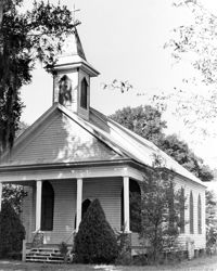
Rockville Historic District - Rockville Presbyterian Church, 2479 Sea Island Yacht Club Road. View of South (Front) elevation. Wadmalaw Island, S.C.;8" x 10" B/W photo. Box 17, Folder 2-14-10. One copy.
Rockville Historic District - John F. Sosnowski House, Grace Chapel Road. View of SW (Front and Side) elevation. Wadmalaw Island, S.C.;8" x 10" B/W photo. Box 17, Folder 2-14-21. One copy.
Rockville Historic District - John F. Sosnowski House, Grace Chapel Road. View of South (Front) elevation. Wadmalaw Island, S.C.;8" x 10" B/W photo. Box 17, Folder 2-14-21. One copy.
Rockville Historic District - Welch's Lane House (Welches Lane House), Sea Island Yacht Club Road. View of SE (Front and Side) elevation. Wadmalaw Island, S.C.;8" x 10" B/W photo. Box 17, Folder 2-14-24. One copy.
Rockville Historic District - Edward D. Bailey House, Sea Island Yacht Club Road. View of East (Front) elevation. Wadmalaw Island, S.C.;6.5" x 10" (and 8" x 10") B/W photo. Box 17, Folder 2-14-23. Two copies.
Rockville Historic District - Presbyterian Manse, Sea Island Yacht Club Road. View of South (Front) elevation. Wadmalaw Island, S.C.;8" x 10" B/W photo. Box 17, Folder 2-14-22. One copy.
Rockville Historic District - Fanny Wilson House, Grace Chapel Road. View of South (Front) elevation. Wadmalaw Island, S.C.;6.5" x 10" B/W photo. Box 17, Folder 2-14-20. One copy.
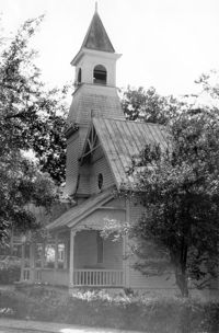
Mount Pleasant Presbyterian Church (Trinity Methodist Church, Hibben Methodist Church, Mount Pleasant Seventh Day Adventist Church), corner of Hibben and Bennet Streets. View of South (Front) elevation. Mount Pleasant, S.C.;6.5" x 10" B/W photo. Box 13, Folder 2-8-1. One copy.
Mount Pleasant Presbyterian Church (Trinity Methodist Church, Hibben Methodist Church, Mount Pleasant Seventh Day Adventist Church), corner of Hibben and Bennet Streets.View of North (Side) elevation. Mount Pleasant, S.C.;10" x 6.5" B/W photo. Box 13, Folder 2-8-2. One copy.
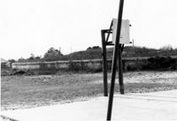
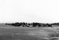
Folly Island Staging Area (Battery Green, U.S. Coast Guard Loran Station, Folly North Site), Address restricted. View facing WNW. Folly Beach, S.C.;8" x 10" B/W photo. Box 17, Folder 2-16-1. One copy.
Rockville Historic District - Cornelia J. Whaley House, Grace Chapel Road. View of South (Front) elevation. Wadmalaw Island, S.C.;6.5" x 10" B/W photo. Box 17, Folder 2-14-19. One copy.