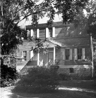
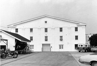
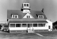
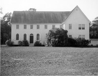
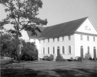
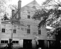
U.S. Coast Guard Historical District, I'on Avenue. Administration Building - View of North (Front) elevation. Sullivans Island, S.C.;6.5" x 10" (and 3.5" x 5") B/W photo. Box 16, Folder 2-13-1. Two copies.
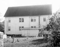
U.S. Coast Guard Historical District, I'on Avenue. Boat House - View of NW (Side and Front) elevation. Sullivans Island, S.C.;6.5" x 10" (and 3.5" x 5") B/W photo. Box 16, Folder 2-13-1. Two copies.
U.S. Coast Guard Historical District, I'on Avenue. Boat House - View of SE (Side and Rear) elevation. Sullivans Island, S.C.;6.5" x 10" (and 3.5" x 5") B/W photo. Box 16, Folder 2-13-1. Two copies.
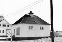
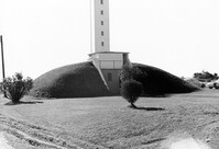
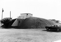
U.S. Coast Guard Historical District, I'on Avenue. Bunker - View of North (Front) elevation. Sullivans Island, S.C.;6.5" x 10" (and 3.5" x 5") B/W photo. Box 16, Folder 2-13-1. Two copies.
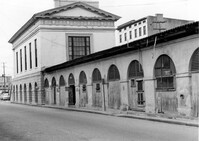
City Market - Market Hall and First Section of Sheds. View of SE (Side and Rear) elevation. Charleston, S.C.;8" x 10" B/W photo. Box 6, Folder 2-1-14. One copy.
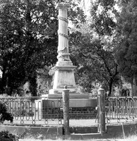
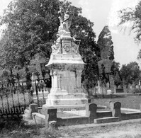
Magnolia Cemetery, Huguenin Avenue and Algonquin Road. Monument of Colonel William Washington. View of South elevation. Charleston, S.C.;8" x 8" B/W photo. Box 5, Folder 2-1-3. One copy.
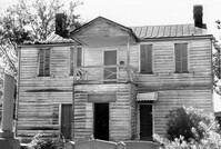
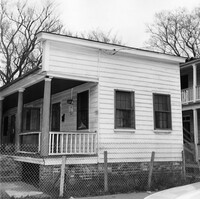
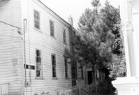
Firetag's Store (Mappus' Store, Six Mile Store), Success Street (between Meeting Street Road and Rivers Avenue). View of SW (Rear and Side) elevation. North Charleston, S.C.;6.5" x 10" B/W photo. Box 5, Folder 2-1-7. One copy.
Firetag's Store (Mappus' Store, Six Mile Store), Success Street (between Meeting Street Road and Rivers Avenue). View of West (Side) elevation. North Charleston, S.C.;6.5" x 10" B/W photo. Box 5, Folder 2-1-7. One copy.
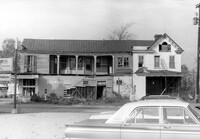
Firetag's Store (Mappus' Store, Six Mile Store), Success Street (between Meeting Street Road and Rivers Avenue). View of East (Side) elevation. North Charleston, S.C.;6.5" x 10" B/W photo. Box 5, Folder 2-1-7. One copy.
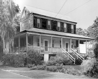
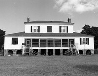
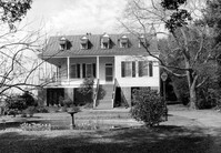
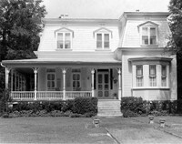
Rockville Historic District - Stevens House (Major Daniel Jenkins House), Maybank Highway. View of South (Front) elevation. Wadmalaw, S.C.;6.5" x 10" (and 8" x 10") B/W photo. Box 17, Folder 2-14-17. Two copies.
Magnolia Cemetery, Huguenin Avenue and Algonquin Road. William B. Smith Mausoleum. View of Side and Front elevation. Charleston, S.C.;8" x 8" B/W photo. Box 5, Folder 2-1-3. One copy.
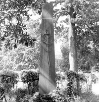
Magnolia Cemetery, Huguenin Avenue and Algonquin Road. Tombstone of Micah Jenkins. View of Front elevation. Charleston, S.C.;8" x 8" B/W photo. Box 5, Folder 2-1-3. One copy.
Cast Iron District, 207-235 Meeting Street - Detail of 231. View of NW (Front) elevation, looking North. Charleston, S.C.;10" x 6.5" B/W photo. Box 9, Folder 2-1-159. Three copies.
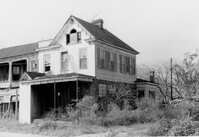
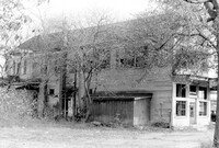
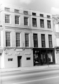
Firetag's Store (Mappus' Store, Six Mile Store) - View of NE (Front and Side) elevation. North Charleston, S.C.;6.5" x 10" B/W photo. Box 5, Folder 2-1-7. One copy.
Cast Iron District, 207-235 Meeting Street - Detail of 223. View of NW (Front) elevation, looking North. Charleston, S.C.;10" x 6.5" B/W photo. Box 9, Folder 2-1-159. Three copies.
Cast Iron District, 207-235 Meeting Street - Detail of 227. View of NW (Front) elevation, looking North. Charleston, S.C.;10" x 6.5" B/W photo. Box 9, Folder 2-1-159. Three copies.
Cast Iron District, 207-235 Meeting Street - Detail of 229. View of NW (Front) elevation, looking North. Charleston, S.C.;6.5" x 10" B/W photo. Box 9, Folder 2-1-159. Three copies.
Cast Iron District, 207-235 Meeting Street - Detail of 233. View of NW (Front) elevation, looking North. Charleston, S.C.;10" x 6.5" B/W photo. Box 9, Folder 2-1-159. Three copies.
Cast Iron District, 207-235 Meeting Street - Detail of 235. View of NW (Front) elevation, looking North. Charleston, S.C.;10" x 6.5" B/W photo. Box 9, Folder 2-1-159. Three copies.
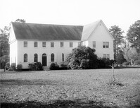
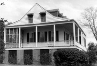
Boone Hall Plantation, Oak Avenue. Main House - View of North (Front) elevation. Mount Pleasant, S.C.;6.5" x 10" B/W photo. Box 10, Folder 2-2-5. One copy.
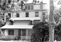
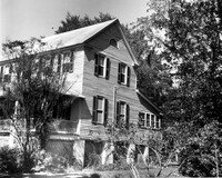
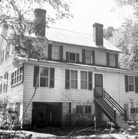
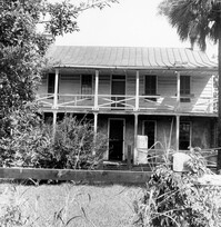
Stiles Point Plantation (Stiles-Hinson-Thompson House), 940 Paul Revere Drive. View of South (Rear) elevation. Charleston S.C.;6.5" x 10" B/W photo. Box 12, Folder 2-4-7. One copy.
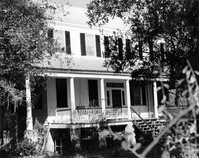
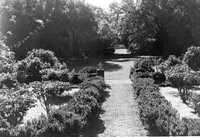
Harrietta Plantation, 7 Mile Road. View of Garden (from Front Porch). North elevation. McClellanville, S.C.;6.5" x 10" B/W photo. Box 14, Folder 2-10-2. One copy.
U.S. Coast Guard Historical District, I'on Avenue. Administration Building - View of South (Rear) elevation. Sullivans Island, S.C.;6.5" x 10" (and 3.5" x 5") B/W photo. Box 16, Folder 2-13-1. Two copies.
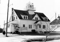
U.S. Coast Guard Historical District, I'on Avenue. Garage - View of East (Front) elevation. Sullivans Island, S.C.;6.5" x 10" (and 3.5" x 5") B/W photo. Box 16, Folder 2-13-1. Two copies.
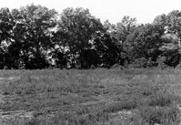
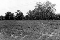
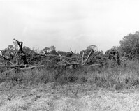
Stono River Rebellion Site (Cato's Rebellion Site), North Side of U.S. Highway 17, west of the Wallace River. View looking NW. Hollywood, S.C.;6.5" x 10" B/W photo. Box 16, Folder 2-11-16. One copy.
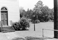
Johns Island Presbyterian Church, 2550 Bohicket Road. Church - Detail View of door and lamppost, Front elevation. Johns Island, S.C.;8" x 10" B/W photo. Box 12, Folder 2-5-4. One copy.
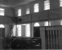
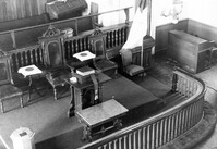
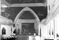
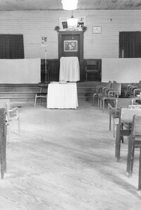
Johns Island Presbyterian Church, 2550 Bohicket Road. Church - Interior View. Sanctuary, Front elevation. Johns Island, S.C.;8" x 10" B/W photo. Box 12, Folder 2-5-4. One copy.
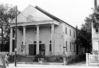
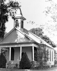
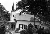
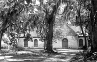
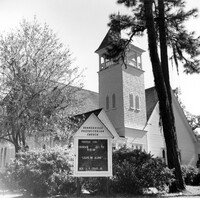
Johns Island Presbyterian Church, 2550 Bohicket Road. Church - View of Front elevation. Johns Island, S.C.;8" x 10" B/W photo. Box 12, Folder 2-5-4. Two copies.
Johns Island Presbyterian Church, 2550 Bohicket Road. Church - View of Front elevation. Johns Island, S.C.;8" x 10" B/W photo. Box 12, Folder 2-5-4. One copy.
Johns Island Presbyterian Church, 2550 Bohicket Road. Church - View of Rear elevation. Johns Island, S.C.;8" x 10" B/W photo. Box 12, Folder 2-5-4. One copy.
Johns Island Presbyterian Church, 2550 Bohicket Road. Church - View of Front elevation. Johns Island, S.C.;8" x 10" B/W photo. Box 12, Folder 2-5-4. One copy.
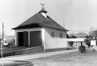
U.S. Coast Guard Historical District, I'on Avenue. Bunker - View of NW (Side and Front) elevation. Sullivans Island, S.C.;6.5" x 10" (and 3.5" x 5") B/W photo. Box 16, Folder 2-13-1. Two copies.
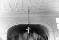
Old Bethel Methodist Church, 222 Calhoun Street. Interior View - Detail of Chancel. NE (Front and Side) elevation. Charleston, S.C.;6.5" x 10" B/W photo. Box 7, Folder 2-1-43. One copy.
Johns Island Presbyterian Church, 2550 Bohicket Road. Church - View of Front and Side elevation. Johns Island, S.C.;8" x 10" B/W photo. Box 12, Folder 2-5-4. One copy.
Johns Island Presbyterian Church, 2550 Bohicket Road. Church - View of Front and Side elevation. Johns Island, S.C.;8" x 10" B/W photo. Box 12, Folder 2-5-4. One copy.
Magnolia Cemetery, Huguenin Avenue and Algonquin Road. Tombstone of Birt family. View of Front elevation. NOTE: Print has superimposed second image. Charleston, S.C.;8" x 8" B/W photo. Box 5, Folder 2-1-3. Two copies.
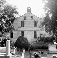
Rockville Historic District - Grace Episcopal Chapel (Grace Epsicopal Church), Grace Chapel Road. View of Front and Side elevation. Wadmalaw, S.C.;10" x 6.5" (and 10" x 8") B/W photo. Box 17, Folder 2-14-18. Two copies.
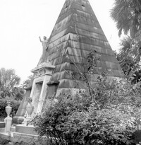
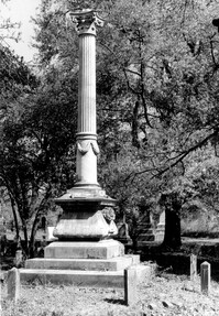
Magnolia Cemetery, Huguenin Avenue and Algonquin Road. Monument of Hugh Swinton Legare. View of Front and Side elevation. Charleston, S.C.;10" x 6.5" B/W photo. Box 5, Folder 2-1-3. One copy.
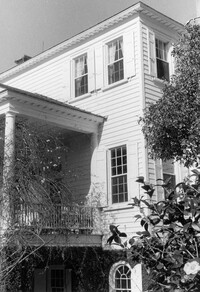
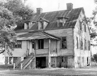
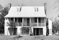
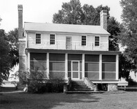
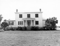
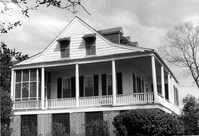
Rockville Historic District - Hagood House (Micah Jenkins House), Grace Chapel Road. View of South (Front) elevation. Wadmalaw Island, S.C.;6.5" x 10" B/W photo. Box 17, Folder 2-14-16. One copy.
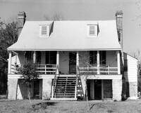
Rockville Historic District - Hagood House (Micah Jenkins House), Grace Chapel Road. View of South (Front) elevation. Wadmalaw Island, S.C.;8" x 10" B/W photo. Box 17, Folder 2-14-16. One copy.
Rockville Historic District - Old Episcopal Rectory, Maybank Highway. View of SE (Side and Front) elevation. Wadmalaw Island, S.C.;6.5" x 10" B/W photo. Box 17, Folder 2-14-13. One copy.
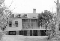
Rockville Historic District - Mary A. Whaley House, Maybank Highway. View of West (Side) elevation. Wadmalaw Island, S.C.;6.5" x 10" B/W photo. Box 17, Folder 2-14-12. One copy.
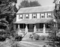
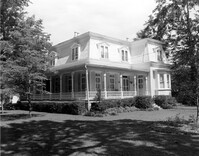
Rockville Historic District - Perry House, Maybank Highway. View of South (Front) elevation. Wadmalaw Island, S.C.;6.5" x 10" B/W photo. Box 17, Folder 2-14-14. One copy.
Rockville Historic District - W.E. Jenkins House (James LaRoche House). View of South (Front) elevation. Wadmalaw Island, S.C.;6.5" x 10" B/W photo. Box 17, Folder 2-14-15. One copy.
Cathedral of St. Luke and St. Paul, 126 Coming Street. Contact Sheet 7 - Views of Front and Sides elevations. Charleston, S.C.;1" x 4.5" B/W photo. Box 20, Folder: Miscellaneous Photos: Scanned Contact Sheets. One copy.
Cathedral of St. Luke and St. Paul, 126 Coming Street. Contact Sheet 7 - Views of Rear and Sides elevations. Charleston, S.C.;1" x 9" B/W photo. Box 20, Folder: Miscellaneous Photos: Scanned Contact Sheets. One copy.
Cathedral of St. Luke and St. Paul, 126 Coming Street. Contact Sheet 7 - Views of Interior. Charleston, S.C.;1" x 4.5" B/W photo. Box 20, Folder: Miscellaneous Photos: Scanned Contact Sheets. One copy.
Stono River Rebellion Site (Cato's Rebellion Site), North Side of U.S. Highway 17, west of the Wallace River. View looking West. Hollywood, S.C.;6.5" x 10" B/W photo. Box 16, Folder 2-11-16. One copy.
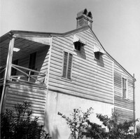
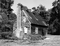
Old House Plantation, Clark Road. Slave Cabin - View of North (Side and Front) elevation. Edisto Island, S.C.;8" x 10" B/W photo. Box 11, Folder 2-3-10. One copy.
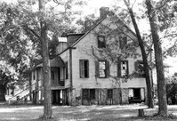
Middleton's Plantation (Chisolm's Plantation; The Launch), S.C. Hwy. 174. View of North (Rear) elevation. Edisto Island, S.C.;8" x 10" B/W photo. Box 11, Folder 2-3-9. One copy.
Middleton's Plantation (Chisolm's Plantation; The Launch), S.C. Hwy. 174. View of South (Front) elevation. Edisto Island, S.C.;8" x 10" B/W photo. Box 11, Folder 2-3-9. Two copies.
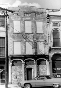
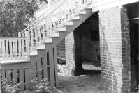
San Souci House, 206 San Souci Street. Detail View of Front Stairs. SW (Front and Side) elevation. Charleston, S.C.;6.5" x 10" B/W photo. Box 8, Folder 2-1-149. One copy.
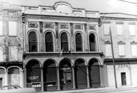
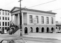
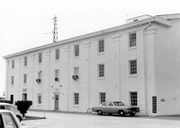
Old Lincolnville Town Hall (Williams Graded School), near intersection of East Randolph Street and East Pinckney Street. View of interior. Lincolnville, S.C.;10" x 6.5" B/W photo. Box 17, Folder 2-15-2. Three copies.
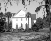
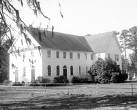
Christ Church Episcopal - Adams Run, State Highway 174. View of South (Side) elevation. Hollywood, S.C.;6.5" x 10" B/W photo. Box 16, Folder 2-11-12. Three copies.
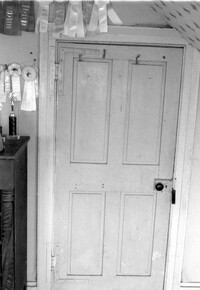
Seaside Plantation (Locksley Hall), off of Cypress Bottom Road. Interior View - 3rd Floor, West Bedroom. Detail of door, West elevation. Edisto Island, S.C.;5" x 7" B/W photo. Box 11, Folder 2-3-12. One copy.
St. Andrews Episcopal Church (Old St. Andrews Parish Church), 2604 Ashley River Road. View of South (Side) elevation. Charleston, S.C.;2" x 3" B/W photo. Box 14, Folder 2-9-7. One copy.
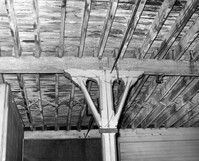
S.C. Railroad Car Shop (AAA Downtown Storage), 44 Line Street. Interior View - Detail of Support Beam. Charleston, S.C.;8" x 10" B/W photo. Box 18, Folder: Charleston: 44 Line Street, South Carolina Car Shop. One copy.
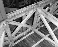
S.C. Railroad Car Shop (AAA Downtown Storage), 44 Line Street. Interior View - Unidentified Detail. Charleston, S.C.;8" x 10" B/W photo. Box 18, Folder: Charleston: 44 Line Street, South Carolina Car Shop. One copy.
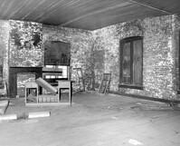
S.C. Railroad Car Shop (AAA Downtown Storage), 44 Line Street. Interior View - Unidentified Room. Charleston, S.C.;8" x 10" B/W photo. Box 18, Folder: Charleston: 44 Line Street, South Carolina Car Shop. One copy.
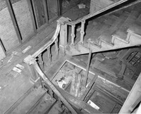
S.C. Railroad Car Shop (AAA Downtown Storage), 44 Line Street. Interior View - Detail of Staircase. Charleston, S.C.;8" x 10" B/W photo. Box 18, Folder: Charleston: 44 Line Street, South Carolina Car Shop. One copy.