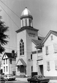
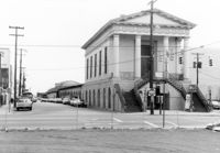
Central Baptist Church, 26 Radcliffe Street. View of SW (Front and Side) elevation. Charleston, S.C.;10" x 6.5" B/W photo. Box 9, Folder 2-1-156. One copy.
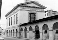
Old Lincolnville Town Hall (Williams Graded School), near intersection of East Randolph Street and East Pinckney Street. View of South (Front) elevation. Lincolnville, S.C.;6.5" x 10" B/W photo. Box 17, Folder 2-15-2. Two copies.
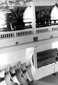
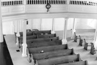
Central Baptist Church, 26 Radcliffe Street. Interior View - Balcony and Pews. NE (Rear and Side) elevation. Charleston, S.C.;10" x 6.5" B/W photo. Box 9, Folder 2-1-156. One copy.
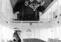
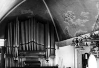
Central Baptist Church, 26 Radcliffe Street. Interior View - Organ and Side. NE (Rear and Side) elevation. Charleston, S.C.;6.5" x 10" B/W photo. Box 9, Folder 2-1-156. One copy.
Central Baptist Church, 26 Radcliffe Street. Interior View - Side and Rear. NE (Rear and Side) elevation. Charleston, S.C.;10" x 6.5" B/W photo. Box 9, Folder 2-1-156. One copy.
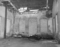
S.C. Railroad Car Shop (AAA Downtown Storage), 44 Line Street. Interior View - Unidentified Detail. Charleston, S.C.;8" x 10" B/W photo. Box 18, Folder: Charleston: 44 Line Street, South Carolina Car Shop. One copy.
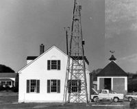
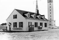
U.S. Coast Guard Historical District, I'on Avenue. Garage - View of South (Side) elevation. Sullivans Island, S.C.;6.5" x 10" (and 3.5" x 5") B/W photo. Box 16, Folder 2-13-1. Two copies.
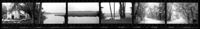
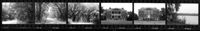
Ashley River Historic District (Highway 61 Historical District). Contact Sheet 6 - Views of Ashley Hall Plantation, Old St. Andrews Parish Church, and Ashley River Road. Charleston, S.C.;1" x 9" B/W photo. Box 20, Folder: Miscellaneous Photos: Scanned Contact Sheets. One copy.
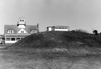
U.S. Coast Guard Historical District, I'on Avenue. Bunker - View of South (Rear) elevation. Sullivans Island, S.C.;6.5" x 10" (and 3.5" x 5") B/W photo. Box 16, Folder 2-13-1. Two copies.
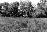
Stono River Rebellion Site (Cato's Rebellion Site), North Side of U.S. Highway 17, west of the Wallace River. View looking North. Hollywood, S.C.;6.5" x 10" B/W photo. Box 16, Folder 2-11-16. One copy.
Ashley River Historic District (Highway 61 Historical District). Contact Sheet 6 - Views of Drayton Hall and Ashley River Road. Charleston, S.C.;1" x 9" B/W photo. Box 20, Folder: Miscellaneous Photos: Scanned Contact Sheets. One copy.
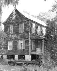
Rockville Historic District - Julia Evelina Whaley House (Marc Tolbert House), Grace Chapel Road. View of SE (Side and Front) elevation. House destroyed by fire in 1984. Wadmalaw Island, S.C.;10" x 8" B/W photo. Box 20, Folder: Charleston County: Wadmalaw Island: Julia Evelina Whaley House. Five copies.
U.S. Coast Guard Historical District, I'on Avenue. Garage - View of NE (Side and Rear) elevation. Sullivans Island, S.C.;6.5" x 10" (and 3.5" x 5") B/W photo. Box 16, Folder 2-13-1. Two copies.
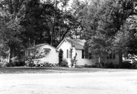
Unidentified House (ca. post-1922) - Contributory to Historic District. View of Front elevation. McClellanville Historic District. McClellanville, S.C.;6.5" x 10" B/W photo. Box 14, Folder 2-10-5. One copy.