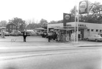
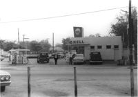
Shell gas station on site affected by the construction of Interstate 26 (I-26). Address: 1227 King Street. Surveyor notations on back of photo: "Dkt.: 10.503. Property owner: Shell Oil Co. Tract: 14-A. Station: 9+50 Rt. (Mt. Pleasant St.). Date: Apr. 20, 1965." [See collection description for explanation of surveyor notations.]
Shell gas station on site affected by the construction of Interstate 26 (I-26). Address: 1227 King Street. Surveyor notations on back of photo: "Dkt.: 10.503. Property owner: Shell Oil Co. Tract: 14-A. Station: 9+50 Rt. (Mt. Pleasant St.). Date: Apr. 20, 1965." [See collection description for explanation of surveyor notations.]
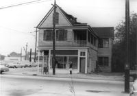
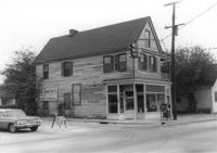
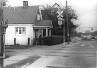
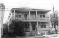
House on site affected by the construction of Interstate 26 (I-26). Address: 1226 King Street. View of street corner; corner of King Street and Mount Pleasant Street. First story is Sanex Cleaners. Surveyor notations on back of photo: "Dkt.: 10.503. Property owner: Mary E. Lea Ward. Tract: 14-B. Station: 11+50 Rt. (Mt. Pleasant St.). Date: Apr. 20, 1965. Partially in R/W." [See collection description for explanation of surveyor notations.]
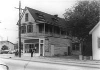
House (corner view) on site affected by the construction of Interstate 26 (I-26). Address: 1226 King Street. View of street corner; corner of King Street and Mount Pleasant Street. First story is Sanex Cleaners. Sign for Coastal Carolina Fair posted on side of building. Surveyor notations on back of photo: "Dkt.: 10.503. Property owner: Mary E. Lea Ward. Tract: 14-B. Station: 11+50 Rt. (Mt. Pleasant St.). Date: Apr. 20, 1965." [See collection description for explanation of surveyor notations.]
House (corner view) on site affected by the construction of Interstate 26 (I-26). Address: 1226 King Street. View of street corner; corner of King Street and Mount Pleasant Street. First story is Sanex Cleaners. Directional sign for St. John Hotel and sign for Coastal Carolina Fair posted on side of building. Surveyor notations on back of photo: "Dkt.: 10.503. Property owner: Mary E. Lea Ward. Tract: 14-B. Station: 11+50 Rt. (Mt. Pleasant St.). Date: Apr. 20, 1965." [See collection description for explanation of surveyor notations.]
House (side view) on site affected by the construction of Interstate 26 (I-26). Address: 1226 King Street. View of street corner; corner of King Street and Mount Pleasant Street. First story is Sanex Cleaners. Directional sign for St. John Hotel and sign for Coastal Carolina Fair posted on side of building. Surveyor notations on back of photo: "Dkt.: 10.503. Property owner: Mary E. Lea Ward. Tract: 14-B. Station: 11+50 Rt. (Mt. Pleasant St.). Date: Apr. 20, 1965." [See collection description for explanation of surveyor notations.]
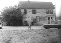
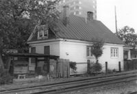
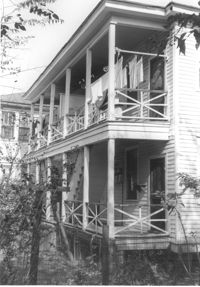
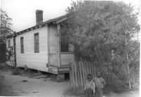
House on site by the construction of Interstate 26 (I-26). Address; 35 Mount Pleasant Street. Number 7 on porch column. At corner of railroad tracks and Mount Pleasant Street. Surveyor notations on back of photo: "Dkt.: 10.503. Property owner: Henry Fritz. Tract: 14-C. Station: 12+10 Rt. (Mt. Pleasant St.). Date: Apr. 20, 1965." [See collection description for explanation of surveyor notations.]
House on site by the construction of Interstate 26 (I-26). Address: 35 Mount Pleasant Street. Corner view from railroad tracks at Mount Pleasant Street. Surveyor notations on back of photo: "Dkt.: 10.503. Property owner: Henry Fritz. Tract: 14-C. Station: 12+10 Rt. (Mt. Pleasant St.). Date: Apr. 20, 1965." [See collection description for explanation of surveyor notations.]
House on site by the construction of Interstate 26 (I-26). Address: 35 Mount Pleasant Street. Corner (rear) view from railroad tracks in foreground. Joseph Floyd Manor (Mount Pleasant Street and King Street) in background. Surveyor notations on back of photo: "Dkt.: 10.503. Property owner: Henry Fritz. Tract: 14-C. Station: 12+10 Rt. (Mt. Pleasant St.). Date: Apr. 20, 1965." [See collection description for explanation of surveyor notations.]
House (side view) on site by the construction of Interstate 26 (I-26). Address: 35 Mount Pleasant Street. View of house from railroad tracks at Mount Pleasant Street. View of street corner, looking down King Street. Surveyor notations on back of photo: "Dkt.: 10.503. Property owner: Henry Fritz. Tract: 14-C. Station: 12+10 Rt. (Mt. Pleasant St.). Date: Apr. 20, 1965." [See collection description for explanation of surveyor notations.]
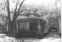
House on site affected by the construction of Interstate 26 (I-26). Address: 78 Fishburne Street. Surveyor notations on back of photo: "Dkt.: 10.517. Property owner: Rosetta E. Richardson. Tract: 124. Station: 24+00 Lt. (Line "1" survey). Date: November 4, 1965. Subject building and entire lot entirely in R/W. Bought." [See collection description for explanation of surveyor notations.]
House on site affected by the construction of Interstate 26 (I-26). Address: 78 Fishburne Street. Surveyor notations on back of photo: "Dkt.: 10.517. Property owner: Rosetta E. Richardson. Tract: 124. Station: 24+00 Lt. (Line "1" survey). Date: November 4, 1965. Subject building and entire lot entirely in R/W. Bought." [See collection description for explanation of surveyor notations.]
House on site affected by the construction of Interstate 26 (I-26). Address: 82 Fishburne Street. Surveyor notations on back of photo: "Dkt.: 10.517. Property owner: Ernest And Mabel Garner. Tract: 125. Station: 23+75 Lt. & Rt. (Line "1" survey). Date: November 4, 1965. Subject building and entire lot entirely in R/W. Bought." [See collection description for explanation of surveyor notations.]
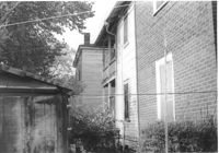
House (side view towards rear) on site affected by the construction of Interstate 26 (I-26). Address: 82 Fishburne Street. Surveyor notations on back of photo: "Dkt.: 10.517. Property owner: Ernest And Mabel Garner. Tract: 125. Station: 23+50 Rt. (Line "1" survey). Date: November 4, 1965. Side view of subject building entirely in R/W. Bought." [See collection description for explanation of surveyor notations.]
House (front and side view) on site affected by the construction of Interstate 26 (I-26). (Presumably where the Crosstown is today or the vicinity.) Address number 82. Surveyor notations on back of photo: "Dkt.: 10.517. Property owner: Ernest And Mabel Garner. Tract: 125. Station: 23+75 Rt. (Line "1" survey). Date: November 4, 1965. Side view of subject building entirely in R/W. Bought." [See collection description for explanation of surveyor notations.]
House on site affected by the construction of Interstate 26 (I-26). Address: 84 Fishburne Street. Surveyor notations on back of photo: "Dkt.: 10.517. Property owner: Miss Fannie A. Patrick. Tract: 126. Station: 23+50 Rt. (Line "1" survey). Date: November 4, 1965. Subject building and lot entirely in R/W. Condemned." [See collection description for explanation of surveyor notations.]
House (front and side view) on site affected by the construction of Interstate 26 (I-26). Address: 84 Fishburne Street. Surveyor notations on back of photo: "Dkt.: 10.517. Property owner: Miss Fannie A. Patrick. Tract: 126. Station: 23+50 Rt. (Line "1" survey). Date: November 4, 1965. Side view of building and showing garage in rear, all in R/W. Condemned." [See collection description for explanation of surveyor notations.]
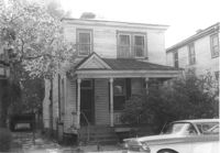
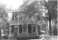
House on site affected by the construction of Interstate 26 (I-26). Address: 7 Carolina Street. Surveyor notations on back of photo: "Dkt.: 10.517. Property owner: Carrie M. Leaphart. Tract: 127. Station: 22+20 Rt. (Line "1" survey). Date: November 4, 1965. Front view of residence. Entire building and lot in R/W." [See collection description for explanation of surveyor notations.]
House (front and side view) on site affected by the construction of Interstate 26 (I-26). Address: 7 Carolina Street. Surveyor notations on back of photo: "Dkt.: 10.517. Property owner: Carrie M. Leaphart. Tract: 127. Station: 22+20 Rt. (Line "1"). Date: November 4, 1965. Side view of building and lot that is entirely in R/W." [See collection description for explanation of surveyor notations.]
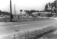
Sign "Opening soon - New 7-11 Food Store," on site affected by the widening of State Road 31 (Reynolds Avenue). Surveyor notations on back of photo: "Dkt.: 10.541. Property owner: Morris P. Sokol, et al. Tract: 1. Station: 2+80 Lt. Date: Apr. 20, 1965. Portion of office building in R/W." [See collection description for explanation of surveyor notations.]
Esso Service Station: at intersection of Orange Grove Road and SC Highway 7 (Sam Rittenberg Boulevard), on site affected by the widening of Routes 7 & 171. Surveyor notations on back of photo: "Dkt.: 10.551. Property owner: Humble Oil Co. Tract: 1. Station: 36±00 Rt. Date: Jul. 22, 1965. West from east side Orange Grove Rd. of range poles on corners of ? area. [See collection description for explanation of surveyor notations.]
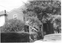
House on site affected by the construction of Interstate 26 (I-26). Address: 5 Carolina Street. Surveyor notations on back of photo: "Dkt.: 10.517. Property owner: I.S. Keith Ellsworth, Sr. Tract: 128. Station: 22+00 Rt. (Line "1"). Date: November 4, 1965. Front and side view of residence and property entirely in R/W." [See collection description for explanation of surveyor notations.]
House on site affected by the construction of Interstate 26 (I-26). Address: 5 Carolina Street. Surveyor notations on back of photo: "Dkt.: 10.517. Property owner: I.S. Keith Ellsworth, Sr. Tract: 128. Station: 22+00 Rt. (Line "1"). Date: November 4, 1965. View of subject building and lot entirely in R/W." [See collection description for explanation of surveyor notations.]
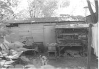
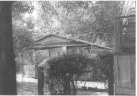
Shed behind house on site affected by the construction of Interstate 26 (I-26). Address: 5 Carolina Street. Surveyor notations on back of photo: "Dkt.: 10.517. Property owner: I.S. Keith Ellsworth, Sr. Tract: 128. Station: 22+50 Rt. (Line "1"). Date: November 4, 1965. Backyard with shed, entirely in R/W." [See collection description for explanation of surveyor notations.]
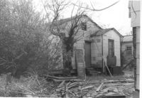
House on site affected by the construction of Interstate 26 (I-26). Address: 3 Carolina Street. Surveyor notations on back of photo: "Dkt.: 10.517. Property owner: Benjamin J. Finklea. Tract: 129. Station: 21+65 Rt. (Line "1"). Date: November 4, 1965. Subject residence and lot entirely in R/W." [See collection description for explanation of surveyor notations.]
House on site affected by the construction of Interstate 26 (I-26). Address: 3 Carolina Street. Surveyor notations on back of photo: "Dkt.: 10.517. Property owner: Benjamin J. Finklea. Tract: 129. Station: 21+65 Rt. (Line "1"). Date: November 4, 1965. Front view of subject residence entirely in R/W." [See collection description for explanation of surveyor notations.]
House (rear) on site affected by the construction of Interstate 26 (I-26). Address: 3 Carolina Street. Surveyor notations on back of photo: "Dkt.: 10.517. Property owner: Benjamin J. Finklea. Tract: 129. Station: 21+65 Rt. (Line "1"). Date: November 4, 1965. Rear view of subject property and building entirely in R/W." [See collection description for explanation of surveyor notations.]
House on site affected by the construction of Interstate 26 (I-26). Address: 1 Carolina Street. Surveyor notations on back of photo: "Dkt.: 10.517. Property owner: Ella W. Britton. Tract: 130. Station: 21+30 Lt. and Rt. (Line "1"). Date: November 4, 1965. Front view of residence and lot entirely in R/W." [See collection description for explanation of surveyor notations.]
House (side view, rear) on site affected by the construction of Interstate 26 (I-26). Address: 1 Carolina Street. Surveyor notations on back of photo: "Dkt.: 10.517. Property owner: Ella W. Britton. Tract: 130. Station: 21+30 Lt. and Rt. (Line "1"). Date: November 4, 1965. Side and rear view of residence and lot, all entirely in R/W." [See collection description for explanation of surveyor notations.]
Garage behind house on site affected by the construction of Interstate 26 (I-26). Address: 1 Carolina Street. Surveyor notations on back of photo: "Dkt.: 10.517. Property owner: I.S. Keith Ellsworth, Sr. Tract: 128. Station: 22+50 Rt. (Line "1"). Date: November 4, 1965. Garage entirely in R/W." [See collection description for explanation of surveyor notations.]
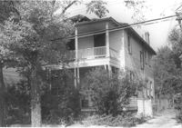
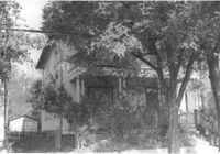
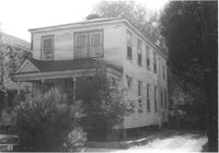
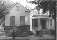
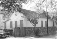
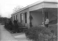
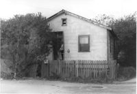
House on site affected by the construction of Interstate 26 (I-26). Address: 310 St. Philip Street. Surveyor notations on back of photo: "Dkt.: 10.517. Property owner: Benjamin W. Steed. Tract: 131. Station: 20+65 Lt. and Rt. (Line "1"). Date: November 4, 1965. Front view of subject residence and lot, all in R/W." [See collection description for explanation of surveyor notations.]
House on site affected by the construction of Interstate 26 (I-26). Address: 310 St. Philip Street. Surveyor notations on back of photo: "Dkt.: 10.517. Property owner: Benjamin W. Steed. Tract: 131. Station: 20+65 Lt. and Rt. (Line "1"). Date: November 4, 1965. Side view of residence entirely in R/W." [See collection description for explanation of surveyor notations.]
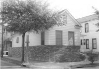
House on site affected by the construction of Interstate 26 (I-26). Address: 310 St. Philip Street. View of street corner; corner of St. Philip Street and Carolina Street. Surveyor notations on back of photo: "Dkt.: 10.517. Property owner: Benjamin W. Steed. Tract: 131. Station: 20+50 Lt. and Rt. (Line "1"). Date: November 4, 1965. Side view of residence in R/W." [See collection description for explanation of surveyor notations.]
House (rear and side view) on site affected by the construction of Interstate 26 (I-26). Address: 310 St. Philip Street. Surveyor notations on back of photo: "Dkt.: 10.517. Property owner: Benjamin W. Steed. Tract: 131. Station: 20+10 Lt. and Rt. (Line "1"). Date: November 4, 1965. Rear view of residence and lot all in R/W." [See collection description for explanation of surveyor notations.]
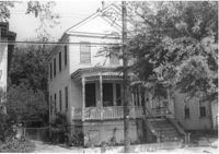
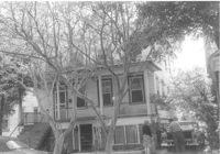
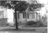
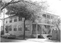
House on site affected by the construction of Interstate 26 (I-26). Address: 693 King Street. Surveyor notations on back of photo: "Dkt.: 10.517. Property owner: Rose Sokol. Tract: 132. Station: 19+20 Lt. and Rt. (Line "1"). Date: November 4, 1965. Front view of subject residence and lot, all in R/W." [See collection description for explanation of surveyor notations.]
House (corner view, rear) on site affected by the construction of Interstate 26 (I-26). Address: 693 King Street. Surveyor notations on back of photo: "Dkt.: 10.517. Property owner: Rose Sokol. Tract: 132. Station: 19+85 Lt. and Rt. (Line "1"). Date: November 4, 1965. Rear view of residence. Complete lot and building in R/W." [See collection description for explanation of surveyor notations.]
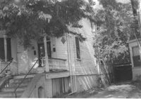
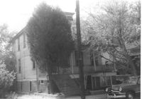
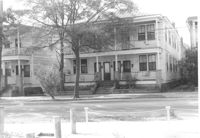
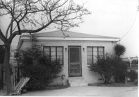
House on site affected by the construction of Interstate 26 (I-26). Address: 691 King Street. Surveyor notations on back of photo: "Dkt.: 10.517. Property owner: Henry Deas Jr., et al. Tract: 133. Station: 18+60 Rt. (Line "1"). Date: November 4, 1965. Front view of subject residence showing portion in R/W. Range poles on new R/W." [See collection description for explanation of surveyor notations.]
House (rear) on site affected by the construction of Interstate 26 (I-26). Address: 691 King Street. Surveyor notations on back of photo: "Dkt.: 10.517. Property owner: Henry Deas Jr., et al. Tract: 133. Station: 18+60 Rt. (Line "1"). Date: November 4, 1965. Rear view of subject residence. Not in R/W. Range poles on new R/W." [See collection description for explanation of surveyor notations.]
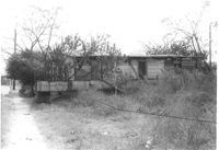
House, likely on Spruill Avenue, on site affected by the construction of Interstate 26 (I-26). Surveyor notations on back of photo: "Dkt.: 10.490. Property owner: Ellen Hartfield, Estate. Tract: 2. Station: 46+15 Rt. (Spruill Ave.). Date: November 4, 1965. Range poles on new R/W. Proximity." [See collection description for explanation of surveyor notations.]
House, likely on Spruill Avenue, on site affected by the construction of Interstate 26 (I-26). Surveyor notations on back of photo: "Dkt.: 10.490. Property owner: Ellen Hartfield, Estate. Tract: 2. Station: 46+15 Rt. (Spruill Ave.). Date: November 4, 1965. Side view of subject property. Range poles on new R/W. Proximity." [See collection description for explanation of surveyor notations.]
House, likely on Spruill Avenue, on site affected by the construction of Interstate 26 (I-26). Surveyor notations on back of photo: "Dkt.: 10.490. Property owner: Ernestine M. Taft. Tract: 3. Station: 47+00 (Spruill Ave.). Date: November 4, 1965. Range poles on new R/W. Proximity." [See collection description for explanation of surveyor notations.]
House, likely on Spruill Avenue, on site affected by the construction of Interstate 26 (I-26). Surveyor notations on back of photo: "Dkt.: 10.490. Property owner: Ernestine M. Taft. Tract: 3. Station: 47+00 (Spruill Ave.). Date: November 4, 1965. Range poles on new R/W. Proximity." [See collection description for explanation of surveyor notations.]
House (rear view), likely on Spruill Avenue, on site affected by the construction of Interstate 26 (I-26). Surveyor notations on back of photo: "Dkt.: 10.490. Property owner: Ernestine M. Taft. Tract: 3. Station: 47+00 (Spruill Ave.). Date: November 4, 1965. Looking north at residence. Proximity." [See collection description for explanation of surveyor notations.]
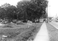
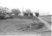
Lot on Spruill Avenue, on site affected by the construction of Interstate 26 (I-26). Houses in background. Surveyor notations on back of photo: "Dkt.: 10.490. Property owner: E.C. Brown. Tract: 28-A. Station: 51+50 Rt. (Spruill Ave.). Date: November 4, 1965. General view of land located in radius at intersection of Spruill Ave. and I-26. Line 'A'." [See collection description for explanation of surveyor notations.]
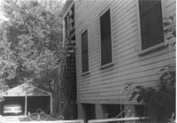
House on Spruill Avenue (rear view) on site affected by the construction of Interstate 26 (I-26). Surveyor notations on back of photo: "Dkt.: 10.490. Property owner: Julia M. Pritchard. Tract: 28-B. Station: 49+20 Rt. (Spruill Ave.) Date: November 4, 1965. Rear view of residence that is partially in R/W. Range poles on new R/W." [See collection description for explanation of surveyor notations.]
House on Spruill Avenue on site affected by the construction of Interstate 26 (I-26). Surveyor notations on back of photo: "Dkt.: 10.490. Property owner: Julia M. Pritchard. Tract: 28-B. Station: 49+50 Rt. (Spruill Ave.) Date: November 4, 1965. Front view of residence that is partially in R/W. Range poles on new R/W." [See collection description for explanation of surveyor notations.]
House on Spruill Avenue (rear view) on site affected by the construction of Interstate 26 (I-26). Surveyor notations on back of photo: "Dkt.: 10.490. Property owner: Julia M. Pritchard. Tract: 28-B. Station: 49+20 Rt. (Spruill Ave.) Date: November 4, 1965. Rear view of residence that is partially in R/W. Range poles on new R/W." [See collection description for explanation of surveyor notations.]
House on Spruill Avenue on site affected by the construction of Interstate 26 (I-26). Surveyor notations on back of photo: "Dkt.: 10.490. Property owner: Julia M. Pritchard. Tract: 28-B. Station: 48+80 Rt. (Spruill Ave.) Date: November 4, 1965. South side of residence that is partially in R/W. Range poles on new R/W." [See collection description for explanation of surveyor notations.]
House on Spruill Avenue on site affected by the construction of Interstate 26 (I-26). [Intersection of Hugo Avenue.] Surveyor notations on back of photo: "Dkt.: 10.490. Property owner: Julia M. Pritchard. Tract: 28-B. Station: 48+80 Rt. (Spruill Ave.) Date: November 4, 1965. Range poles on new R/W. Building partially in R/W." [See collection description for explanation of surveyor notations.]
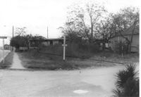
Lot on Spruill Avenue at intersection of Hugo Avenue, on site affected by the construction of Interstate 26 (I-26). View of street corner. House in photo 1103 in background. Surveyor notations on back of photo: "Dkt.: 10.490. Property owner: Bunch Realty Co. Tract: 28-D. Station: 48+00 Rt. (Spruill Ave.) Date: November 4, 1965. Take includes entire lot. Range poles on new R/W." [See collection description for explanation of surveyor notations.]