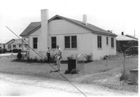
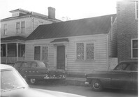
House (corner view, rear) on site affected by the construction of Interstate 26 (I-26). Possibly on Rivers Avenue. Surveyor notations on back of photo: "Dkt.: 10.486. Property owner: Mrs. Mertice S. Greenhill. Tract: 26. Station: 8+50 Lt. (Line E). Date: May 30, 1961. In R/W - Bought." [See collection description for explanation of surveyor notations.]
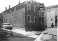
House on Sheppard Street (rear view) on site affected by the construction of the Crosstown. Address: 137 Sheppard Street. Surveyor notations on back of photo: "Dkt.: 10.524. Property owner: Frank Williams. Tract: 126. Station: 89+40 Lt. Date: Dec. 2, 1964. In R/W - Bought." [See collection description for explanation of surveyor notations.]
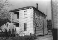
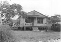
House on Sheppard Street on site affected by the construction of the Crosstown. Address: 135 Sheppard Street. Surveyor notations on back of photo: "Dkt.: 10.524. Property owner: William Delestine, et al. Tract: 127. Station: 89+80 CL. Date: Dec. 2, 1964. In R/W - Bought." [See collection description for explanation of surveyor notations.]
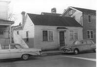
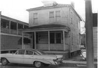
House on site affected by the construction of the Crosstown. Address: 139 Sheppard Street. Surveyor notations on back of photo: "Dkt.: 10.524. Property owner: Wilmot J. Frasier. Tract: 125. Station: 89+15 Lt. Date: Dec. 2, 1964. In R/W - Bought." [See collection description for explanation of surveyor notations.]
House on site affected by the construction of the Crosstown. Address: 139 Sheppard Street. Surveyor notations on back of photo: "Dkt.: 10.524. Property owner: Wilmot J. Frasier. Tract: 125. Station: 89+15 Lt. Date: Dec. 2, 1964. In R/W - Bought." [See collection description for explanation of surveyor notations.]
House on Sheppard Street on site affected by the construction of the Crosstown. Address: 137 Sheppard Street. Surveyor notations on back of photo: "Dkt.: 10.524. Property owner: Frank Williams. Tract: 126. Station: 89+40 Lt. Date: Dec. 2, 1964. In R/W - Bought." [See collection description for explanation of surveyor notations.]
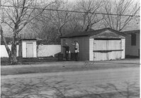
Garage and shed on site affected by the construction of Interstate 26 (I-26). Surveyor notations on back of photo: "Dkt.: 10.490. Property owner: Mostester Brown [Mostester Brown?]. Tract: 87-C. Station: 5825+45 Rt. Date: March 22, 1962. In R/W - Bought." [See collection description for explanation of surveyor notations.]
Garage and shed on site affected by the construction of Interstate 26 (I-26). Surveyor notations on back of photo: "Dkt.: 10.490. Property owner: Mostester Brown [Montester Brown?]. Tract: 87-C. Station: 5825+45 Rt. [Undated.] In R/W - Bought." [See collection description for explanation of surveyor notations.]
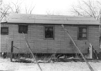
House (side view) on site affected by the construction of Interstate 26 (I-26). Address: 15 Addison Street (rear). Surveyor notations on back of photo: "Dkt.: 10.503. Property owner: Maggie Tobias. Tract: 100-A. Station: 5920+45 Lt. Date: Feb. 20, 1963. Outside R/W bought." [See collection description for explanation of surveyor notations.]
House on site affected by the construction of Interstate 26 (I-26). Building address number 208. Surveyor notations on back of photo: "Dkt.: 10.490. Property owner: Cora L. Gantt, et al. Tract: 65. Station: 5802+90 Lt. Line 'F'. Date: September 12, 1962. In R/W - Bought." [See collection description for explanation of surveyor notations.]
Limit your search
SCDOT Photographs: Properties in the Right-of-Way✖[remove]2,276