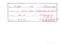
Example of information written on back of photograph: Docket Number, Route, County, Property Owner, Tract, Station, Date, and added note pertaining to right-of-way.
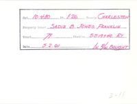
Example of information written on back of photograph: Docket Number, Route, County, Property Owner, Tract, Station, Date, and added note pertaining to right-of-way.
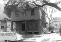
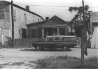
Building (corner view, rear) on site affected by the construction of the Crosstown. Address: 120 Drake Street (based on buildings across the street). Harrisson & Co. Fishing Tacking Hardware; see next photo. Elevated roadway (presumably the off-ramp of the Grace Memorial Bridge) in background. Surveyor notations on back of photo: "Dkt.: 10.518. Property owner: Frank J. Kelly. Tract: 78. Station: 55+60 Rt. N.B. lane Route 17. Date: Mar. 7, 1963." [See collection description for explanation of surveyor notations.]
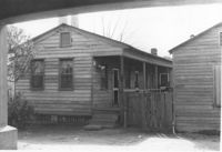
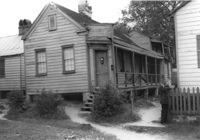
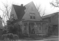
House (freedman's cottage) on site affected by the construction of the Crosstown. Address: 28 Lee Street (28 1/3 Lee Street). Billboard from Photo 127 in background. Surveyor notations on back of photo: "Dkt.: 10.518. Property owner: Sara Johnson, et al. Tract: 81. Station: 53+45 Rt. N.B. lane Route 17. Date: Mar. 7, 1963." [See collection description for explanation of surveyor notations.]
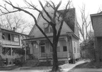
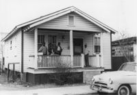
House (freedman's cottage) on site affected by the construction of the Crosstown. Address: 6 Lee Street. Surveyor notations on back of photo: "Dkt.: 10.518. Property owner: William Parrineau, et al. Tract: 72. Station: 53+60 Lt. N.B. lane Route 17. 30+30Rt. Lee Street survey. Date: Mar. 7, 1963. In R/W - Bought." [See collection description for explanation of surveyor notations.]
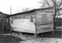
Outbuilding on site affected by the construction of the Crosstown. Address: 39 Lee Street (south side of street). Surveyor notations on back of photo: "Dkt.: 10.518. Property owner: Yetta B. Rosen. Tract: 69. Station: 52+70 Rt. N.B. lane Route 17. Date: Mar. 7, 1963. In R/W - Bought." [See collection description for explanation of surveyor notations.]
Orkin Pest Control - Termite Control, corner of Ashley Hall Road and Route 7 (Sam Rittenberg Boulevard), on site affected by the widening of Routes 7 & 171. Surveyor notations on back of photo: "Dkt.: 10.551. Property owner: Atlantic Investment & Development Co. Tract: 4. Station: 127±00 Rt. Date: Jul. 22, 1965. Same as Photo 5, view from across Ashley Hall Rd. looking north. [See collection description for explanation of surveyor notations.]
House and shed at end of driveway on site affected by the construction of Interstate 26 (I-26). Address: 2137 Courtland Avenue. Surveyor notations on back of photo: "Dkt.: 10.490. Property owner: Baynard C. Lynes. Tract: 167. Station: 50' Rt. Sta. 5883+10. Date: May 15, 1962. In R/W - Bought." [See collection description for explanation of surveyor notations.]
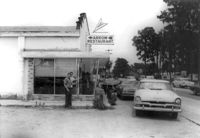
Arrow Restaurant, on site affected by the widening of State Road 13 (Remount Road). Surveyor notations on back of photo: "Dkt.: 10.562. Property owner: F.L. Parks, Jr. Tract: 3. Date: Jul. 12, 1967." [See collection description for explanation of surveyor notations.]
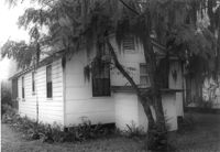
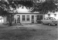
House on site affected by the widening of State Road 13 (Remount Road). Rear view. Surveyor notations on back of photo: "Dkt.: 10.562. Property owner: Charles R. Roberson. Tract: 36-A. Date: Jul. 19, 1967." [See collection description for explanation of surveyor notations.]
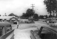
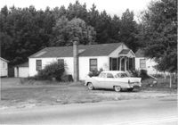
Site affected by the widening of State Road 13 (Remount Road). Surveyor notations on back of photo: "Dkt.: 10.562. Property owner: F.L. Parks, Jr. Tract: 3. Date: Jul. 12, 1967." [See collection description for explanation of surveyor notations.]
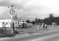
Sinclair gasoline station on site affected by the construction of Interstate 26 (I-26). Surveyor notations on back of photo: "Dkt.: 10.471. Property owner: Sinclair Refining Co. Tract: 138. Station: 1+50 Rt. (Remount Road). Date: Aug. 23, 1960. Proximity." [See collection description for explanation of surveyor notations.]
House (freedman's cottage) on site affected by the construction of the Crosstown. Address: 26 Kracke Street. Surveyor notations on back of photo: "Dkt.: 10.524. Property owner: Julia Brown. Tract: 68. Station: 77+55 Lt. Date: Oct. 14, 1964. Proximity." [See collection description for explanation of surveyor notations.]
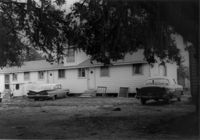
Dwelling on site affected by the construction of Interstate 26 (I-26). Appears to be a triplex or apartment house. Surveyor notations on back of photo: "Dkt.: 10.471. Property owner: Palmetto Flower Corp. Tract: 143. Station: 5480+00 Lt. Date: Aug. 23, 1960. Building No. 2. In R/W - Bought." [See collection description for explanation of surveyor notations.]
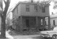
House on site affected by the construction of the Crosstown. Address: 121 Sheppard Street. Surveyor notations on back of photo: "Dkt.: 10.524. Property owner: Erline B. Wertan. Tract: 138. Station: 17+05 Rt. N.B. lane. Date: Dec. 2, 1964. In R/W - Bought." [See collection description for explanation of surveyor notations.]
House on site affected by the construction of the Crosstown. Address: 121 Sheppard Street. Surveyor notations on back of photo: "Dkt.: 10.524. Property owner: Erline B. Wertan. Tract: 138. Station: 17+05 Rt. N.B. lane. Date: Dec. 2, 1964. In R/W - Bought." [See collection description for explanation of surveyor notations.]
Dwelling on site affected by the construction of Interstate 26 (I-26). Appears to be a duplex. Surveyor notations on back of photo: "Dkt.: 10.471. Property owner: Palmetto Flower Corp. Tract: 143. Station: 5480+30 Lt. Date: Aug. 23, 1960. Building No. 4. In R/W - Bought." [See collection description for explanation of surveyor notations.]
House on site affected by the construction of the Crosstown. Address: 119 Sheppard Street. Surveyor notations on back of photo: "Dkt.: 10.524. Property owner: Scott M. Boyle. Tract: 139. Station: 17+45 Rt. N.B. lane. Date: Dec. 2, 1964. In R/W - Bought." [See collection description for explanation of surveyor notations.]
House on site affected by the construction of the Crosstown. Address: 119 Sheppard Street. Surveyor notations on back of photo: "Dkt.: 10.524. Property owner: Scott M. Boyle. Tract: 139. Station: 17+45 Rt. N.B. lane. Date: Dec. 2, 1964. In R/W - Bought." [See collection description for explanation of surveyor notations.]
House on site affected by the construction of Interstate 26 (I-26). Surveyor notations on back of photo: "Dkt.: 10.471. Property owner: Pauline P. Badger. Tract: 132. Station: 5476+00 Lt. Date: Aug. 23, 1960. In R/W - Bought." [See collection description for explanation of surveyor notations.]
House (freedman's cottage) on site affected by the construction of Interstate 26 (I-26). Building address number 2003(?). Surveyor notations on back of photo: "Dkt.: 10.490. Property owner: L. Bradley. Tract: 39. Station: 5797+70 on CL Line 'G'. Date: September 11, 1962. In R/W - Bought." [See collection description for explanation of surveyor notations.]
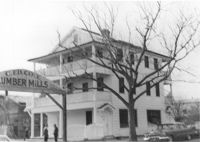
Cole Lumber Company, presumably main office building, on site affected by the construction of Interstate 26 (I-26). Sign arches over the entrance: C. Ed Cole Lumber Mills. Address from 1961 City Directory: 293 Huger Street. Address from 1951 Sanborn Map: 17 Huger Street. Surveyor notations on back of photo: "Dkt.: 10.517. Property owner: Charles E. Cole Lumber Co. Tract 1. Station: 5937+70 Lt. Date: February 21, 1963." [See collection description for explanation of surveyor notations.]
House (freedman's cottage) (rear view) on site affected by the construction of Interstate 26 (I-26). Surveyor notations on back of photo: "Dkt.: 10.490. Property owner: Janie Simmons. Tract: 41. Station: 5798+30 on CL Line 'G'. Date: September 12, 1962. In R/W - Bought." [See collection description for explanation of surveyor notations.]
House (rear view) on site affected by the construction of Interstate 26 (I-26). Address: 48 Sheppard Street. Surveyor notations on back of photo: "Dkt.: 10.517. Property owner: Michael Criley. Tract: 74. Station: 5959+75 CL - Line 3. Date: March 5, 1963. In R/W - Bought." [See collection description for explanation of surveyor notations.]
House (rear view) on site affected by the construction of Interstate 26 (I-26). [Building address number 1989.] Surveyor notations on back of photo: "Dkt.: 10.490. Property owner: John Hamilton. Tract: 33. Station: 5795+35 on CL Line 'A'. Date: September 11, 1962. In R/W - Bought." [See collection description for explanation of surveyor notations.]
House on site affected by the construction of Interstate 26 (I-26). Address: 46 Sheppard Street. Surveyor notations on back of photo: "Dkt.: 10.517. Property owner: Mary Wolfe Hennersby. Tract: 73. Station: 5960+15 CL - Line 3. Date: March 5, 1963. In R/W - Bought." [See collection description for explanation of surveyor notations.]
Limit your search
SCDOT Photographs: Properties in the Right-of-Way✖[remove]2,276