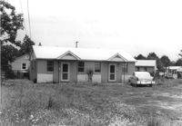
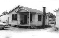
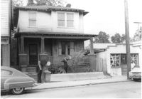
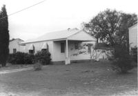
House on site affected by the construction of Interstate 26 (I-26). Surveyor notations on back of photo: "Dkt.: 10.471. Property owner: C.D. Jones. Tract: 101. Station: 5377± Rt. Date: Aug. 23, 1960. Proximity." [See collection description for explanation of surveyor notations.]
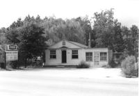
Building, on site affected by the construction of the Crosstown. Address: 209 Spring Street. Friendly Barber Shop and Spot Light Radio TV Service. Front facade has stepped parapet. Neighboring buildings on either side seen; Address 207 Spring Street and 211 Spring Street. Surveyor notations on back of photo: "Dkt.: 10.524. Property owner: Maybell Fields. Tract: 166. Station: 20+00 Rt. Spring Street. Date: Dec. 2, 1964." [See collection description for explanation of surveyor notations.]
Corner of house, with view of shed at rear of property, on site affected by the construction of Interstate 26 (I-26). Possibly on Rivers Avenue. Surveyor notations on back of photo: "Dkt.: 10.486. Property owner: Mrs. Ida K. Hill. Tract: 16. Station: 12+00 Rt. (Main Line). Date: May 30, 1961. In R/W - Bought." [See collection description for explanation of surveyor notations.]
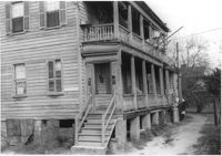
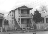
Side view of house (duplex) on site affected by the construction of Interstate 26 (I-26). Building address numbers 1809A and 1809B. Possibly on Rivers Avenue. Surveyor notations on back of photo: "Dkt.: 10.486. Property owner: Joseph S. & Vivian G. Walsh. Tract: 14. Station: 12+00 (Line D). Date: May 30, 1961. In R/W - Bought." [See collection description for explanation of surveyor notations.]
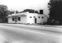
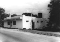
Side view of The Fork (restaurant) and lot on site affected by the construction of the Crosstown. Address: 223 Spring Street. Signs for the Castle Pinckney Motel and The Fork Restaurant at right. Presumably on Spring Street. Surveyor notations on back of photo: "Dkt.: 10.524. Property owner: The Fork Co. Inc. Tract: 156. Station: 13±00 Rt. Spring Street. Date: Dec. 2, 1964." [See collection description for explanation of surveyor notations.]
House (duplex) on site affected by the construction of Interstate 26 (I-26). Building address numbers 1809A and 1809B. Possibly on Rivers Avenue. Surveyor notations on back of photo: "Dkt.: 10.486. Property owner: Joseph S. & Vivian G. Walsh. Tract: 14. Station: 12+00 (Line D). Date: May 30, 1961. In R/W - Bought." [See collection description for explanation of surveyor notations.]
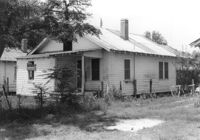
House (rear view) on site affected by the construction of Interstate 26 (I-26). Building address number 1812. Possibly on Rivers Avenue. Surveyor notations on back of photo: "Dkt.: 10.486. Property owner: J.A. Livingston. Tract: 15. Station: 11+80 Lt. Date: May 30, 1961. In R/W - Bought." [See collection description for explanation of surveyor notations.]
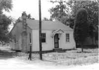
House on site affected by the construction of Interstate 26 (I-26). Building address number 1806. Possibly on Rivers Avenue. Surveyor notations on back of photo: "Dkt.: 10.486. Property owner: Cleve G. Murray. Tract: 12. Station: 10+90 Lt. Date: May 30, 1961. In R/W - Bought." [See collection description for explanation of surveyor notations.]
Side view of The Fork (restaurant) and lot on site affected by the construction of the Crosstown. Address: 223 Spring Street. Surveyor notations on back of photo: "Dkt.: 10.524. Property owner: The Fork Co. Inc. Tract: 156. Station: 13±00 Rt. Spring Street. Date: Dec. 2, 1964." [See collection description for explanation of surveyor notations.]
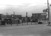
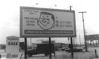
Billboard for BlueCross BlueShield on site affected by construction of the Crosstown. Billboard for Charleston Inn and 233 Spring Street (Shell gas station) in background. Presumably on Spring Street. Surveyor notations on back of photo: "Dkt.: 10.524. Property owner: Turner Advertising Co. Tract: 155. Station: 11±00 Rt. Spring Street. Date: Dec. 2, 1964." [See collection description for explanation of surveyor notations.]
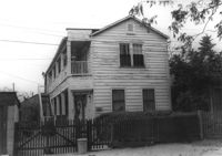
House on site affected by the construction of Interstate 26 (I-26). Address: 691 King Street. Surveyor notations on back of photo: "Dkt.: 10.517. Property owner: Henry Deas Jr., et al. Tract: 133. Station: 18+60 Rt. (Line "1"). Date: November 4, 1965. Front view of subject residence showing portion in R/W. Range poles on new R/W." [See collection description for explanation of surveyor notations.]
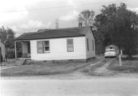
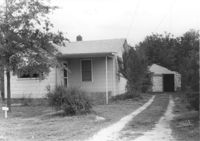
House and shed at end of driveway on site affected by the construction of Interstate 26 (I-26). Address: 2133 Courtland Avenue. Surveyor notations on back of photo: "Dkt.: 10.490. Property owner: J.H. Black, et al. Tract: 165. Station: 5883±10 Lt. Date: August 29, 1962. In R/W - Bought." [See collection description for explanation of surveyor notations.]
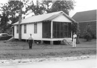
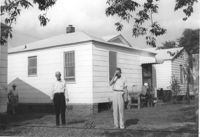
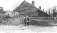
View from street of house and sheds on site affected by the construction of Interstate 26 (I-26). Address: 1334 Rutledge Avenue. Surveyor notations on back of photo: "Dkt.: 10.490. Property owner: Heyward Barnes. Tract: 168. Station: 125' Rt. Sta. 5882+70. Date: May 15, 1962. Proximity." [See collection description for explanation of surveyor notations.]
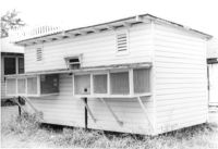
Structure (possibly a bird coop) on site affected by the construction of Interstate 26 (I-26).Address: 1338 Rutledge Avenue. Surveyor notations on back of photo: "Dkt.: 10.490. Property owner: Louise S. Carter. Tract: 157. Station: 5880+90 Lt. Date: May 15, 1962. In R/W - Bought." [See collection description for explanation of surveyor notations.]
House (corner view, rear) on site affected by the construction of Interstate 26 (I-26). Address: 2127 Courtland Avenue. Surveyor notations on back of photo: "Dkt.: 10.490. Property owner: Geo. L. Johnson [George L. Johnson]. Tract: 162. Station: 5883±70 Lt. Date: August 29, 1962. Proximity." [See collection description for explanation of surveyor notations.]
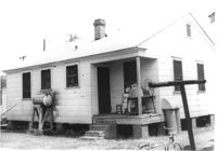
House (rear view) on site affected by the construction of Interstate 26 (I-26). Address: Carters Court. Surveyor notations on back of photo: "Dkt.: 10.490. Property owner: Louise S. Carter. Tract: 151. Station: 30' Lt. Sta. 5880+10. Date: May 15, 1962. In R/W - Bought." [See collection description for explanation of surveyor notations.]
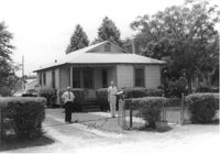
House on site affected by the construction of Interstate 26 (I-26). Address: 2 Carters Court. Surveyor notations on back of photo: "Dkt.: 10.490. Property owner: Louise S. Carter. Tract: 150. Station: 25' Lt. Sta. 5880+55. Date: May 15, 1962. In R/W - Bought." [See collection description for explanation of surveyor notations.]
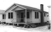
House on site affected by the construction of Interstate 26 (I-26). Address: 4 Carters Court. Surveyor notations on back of photo: "Dkt.: 10.490. Property owner: Louise S. Carter. Tract: 149. Station: 35' Lt. Sta. 5881+00. Date: May 15, 1962. In R/W - Bought." [See collection description for explanation of surveyor notations.]
House on site affected by the construction of Interstate 26 (I-26). Address: Carters Court. Surveyor notations on back of photo: "Dkt.: 10.490. Property owner: Louise S. Carter. Tract: 151. Station: 30' Lt. Sta. 5880+10. Date: May 15, 1962. In R/W - Bought." [See collection description for explanation of surveyor notations.]
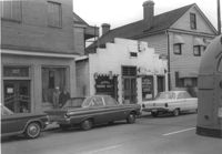
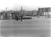
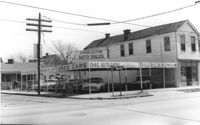
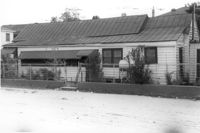
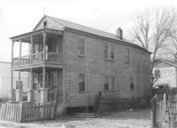
Corner of Meeting Street and Cooper Street. Charleston Auto Sales (510 Meeting Street) and Infinger's Shoe Store (508 Meeting Street), on site affected by the construction of the Crosstown. Surveyor notations on back of photo: "Dkt.: 10.518. Property owner: Robert L. Knoth. Tract: 14. Station: 5962+85 CL of Line 3 of the S.B. lane of Route 17. Date: Mar. 6, 1963. In R/W - Bought. [See collection description for explanation of surveyor notations.]
House (rear corner view) on site affected by the construction of the Crosstown. Address: 110 Bogard Street. Surveyor notations on back of photo: "Dkt.: 10.524. Property owner: Thomassina Elizabeth McCray. Tract: 72. Station: 76+60 Rt. Date: Oct. 14, 1964. In R/W - Bought." [See collection description for explanation of surveyor notations.]
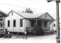
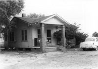
House on site affected by the construction of the Crosstown. Address: 71 Kracke Street. Surveyor notations on back of photo: "Dkt.: 10.524. Property owner: William Henry Godfrey. Tract: 66. Station: 76+10 Lt. Date: Oct. 14, 1964. Portion in R/W to be removed." [See collection description for explanation of surveyor notations.]
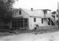
House (rear view) and lot on site affected by the construction of the Crosstown. Address: 18-20 Wescott Street. Surveyor notations on back of photo: "Dkt.: 10.524. Property owner: Ralph E. Thornley, et al. Tract: 11. Station: 62+10 Lt. Date: Oct. 13, 1964." [See collection description for explanation of surveyor notations.]
Side view of house on site affected by the construction of the Crosstown. Address: 119 Bogard Street. Surveyor notations on back of photo: "Dkt.: 10.524. Property owner: Rebecca S. Cooper. Tract: 55. Station: 73+90 Rt. Date: Oct. 14, 1964. In R/W - Bought." [See collection description for explanation of surveyor notations.]
House on site affected by the construction of the Crosstown. Address: 110 Bogard Street. Surveyor notations on back of photo: "Dkt.: 10.524. Property owner: Thomassina Elizabeth McCray. Tract: 72. Station: 76+60 Rt. Date: Oct. 14, 1964. In R/W - Bought." [See collection description for explanation of surveyor notations.]
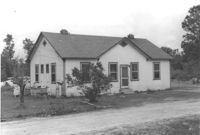
House on site affected by the construction of the Crosstown. Address: 190 Spring Street. Surveyor notations on back of photo: "Dkt.: 10.524. Property owner: E.H. Heidman, Est. Tract: 18. Station: 24± Lt. (Spring Street). Date: Oct. 13, 1964. Portion in R/W to be removed." [See collection description for explanation of surveyor notations.]
House on site affected by the construction of the Crosstown. Address: 190 Spring Street. Surveyor notations on back of photo: "Dkt.: 10.524. Property owner: E.H. Heidman, Est. Tract: 18. Station: 24± Lt. (Spring Street). Date: Oct. 13, 1964. Portion in R/W to be removed." [See collection description for explanation of surveyor notations.]
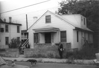
House on site affected by the construction of the Crosstown. Address: 22 Wescott Street. Surveyor notations on back of photo: "Dkt.: 10.524. Property owner: Ida J. Gantt. Tract: 10. Station: 61+20 Lt. Date: Oct. 13, 1964." [See collection description for explanation of surveyor notations.]
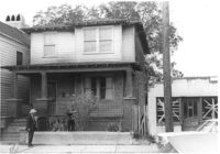
House on site affected by the construction of Interstate 26 (I-26). Building address number 183. Garage/shed at end of driveway. Surveyor notations on back of photo: "Dkt.: 10.480. Property owner: D.M. Swails, et al. Tract: 128. Station: 5650+40 Rt. Date: May 2, 1961. In R/W - Bought." [See collection description for explanation of surveyor notations.]
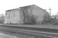
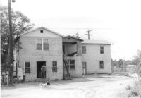
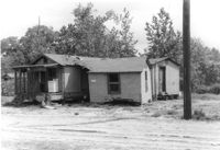
Building by railroad tracks, on site affected by the construction of Interstate 26 (I-26). Surveyor notations on back of photo: "Dkt.: 10.480. Property owner: Raymond O. Dion. Tract: 107. Station: 5630± to 5636±. Date: May 2, 1961. To be demolished." [See collection description for explanation of surveyor notations.]
House on site affected by the construction of Interstate 26 (I-26). Surveyor notations on back of photo: "Dkt.: 10.480. Property owner: Preston H. Mundy. Tract: 104. Station: 5574+70 Lt. (Line J). Date: May 2, 1961. In R/W - Bought." [See collection description for explanation of surveyor notations.]
House on site affected by the construction of Interstate 26 (I-26). Possibly on Rivers Avenue. Surveyor notations on back of photo: "Dkt.: 10.486. Property owner: John W. Faulkner. Tract: 3. Station: 6+40 Lt. Date: May 30, 1961. Proximity." [See collection description for explanation of surveyor notations.]
House on site affected by the construction of Interstate 26 (I-26). Surveyor notations on back of photo: "Dkt.: 10.480. Property owner: Paul W. Wall. Tract: 158. Station: 5670+20 Rt. Date: May 1, 1961. In R/W - Bought." [See collection description for explanation of surveyor notations.]
House on site affected by the construction of Interstate 26 (I-26). Surveyor notations on back of photo: "Dkt.: 10.480. Property owner: G.B. Lewis. Tract: 140. Station: 5657+60 Rt. Date: May 1, 1961. In R/W - Bought." [See collection description for explanation of surveyor notations.]
Owen's Dry Cleaners, on site affected by the construction of Interstate 26 (I-26). Building address number 2160. Surveyor notations on back of photo: "Dkt.: 10.471. Property owner: Willa W.S. Owens. Tract: 136. Station: 5477+80 Lt. Date: Aug. 23, 1960. In R/W - Bought." [See collection description for explanation of surveyor notations.]
House or apartment building on site affected by the construction of Interstate 26 (I-26). Pepsi-Cola sign and mailbox with address number 164 next to building. Surveyor notations on back of photo: "Dkt.: 10.480. Property owner: Central McMillan, et al. Tract: 38. Station: 5508+40 Rt. Date: May 2, 1961. In R/W - Bought." [See collection description for explanation of surveyor notations.]
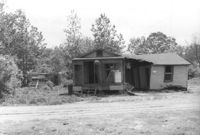
House in dilapidated condition and adjacent structure on site affected by the construction of Interstate 26 (I-26). Building address number 316. Surveyor notations on back of photo: "Dkt.: 10.480. Property owner: Fred McMillian, et al. Tract: 41. Station: 5509+50 Lt. Date: May 2, 1961. In R/W - Bought." [See collection description for explanation of surveyor notations.]
House in dilapidated condition and adjacent structure on site affected by the construction of Interstate 26 (I-26). Building address number 316. Surveyor notations on back of photo: "Dkt.: 10.480. Property owner: Fred McMillian, et al. Tract: 41. Station: 5509+50 Lt. Date: May 2, 1961. In R/W - Bought." [See collection description for explanation of surveyor notations.]
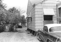
House on site affected by the construction of Interstate 26 (I-26). Driveway leads to garage/shed. Surveyor notations on back of photo: "Dkt.: 10.480. Property owner: James W. Sadler. Tract: 123. Station: 5647+60 Lt. Date: May 1, 1961. In R/W - Bought." [See collection description for explanation of surveyor notations.]
House on site affected by the construction of Interstate 26 (I-26). Address: 10 Lenox Street. Surveyor notations on back of photo: "Dkt.: 10.503. Property owner: Benjamin Thompson. Tract: 37. Station: 5901+50 Lt. Date: Feb. 19, 1963. In R/W - Bought." [See collection description for explanation of surveyor notations.]
House on site affected by the construction of Interstate 26 (I-26). Address: 5 Lenox Street. Surveyor notations on back of photo: "Dkt.: 10.503. Property owner: Estelle Thompson. Tract: 40. Station: 5902+60 Lt. Date: Feb. 19, 1963. In R/W - Bought." [See collection description for explanation of surveyor notations.]
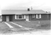
House on site affected by the construction of Interstate 26 (I-26). Address: 14 Lenox street. Surveyor notations on back of photo: "Dkt.: 10.503. Property owner: Harry Thompson. Tract: 38. Station: 5901+50 Rt. Date: Feb. 19, 1963. In R/W - Bought." [See collection description for explanation of surveyor notations.]
House on site affected by the construction of Interstate 26 (I-26). Address: 16 Lenox Street. Surveyor notations on back of photo: "Dkt.: 10.503. Property owner: Harry Thompson. Tract: 38. Station: 5901+50 Rt. Date: Feb. 19, 1963. In R/W - Bought." [See collection description for explanation of surveyor notations.]
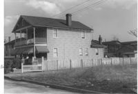
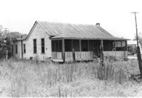
House (rear and side view) on site affected by the construction of the Crosstown. Address: 215 Spring Street. Corner of Spring Street and Vaughan Street. Paint and hardware store across the street. Surveyor notations on back of photo: "Dkt.: 10.524. Property owner: Ruby E. Jacobs. Tract: 163. Station: 18+85 Rt. Spring Street. Date: Dec. 2, 1964. Partially In R/W - Bought." [See collection description for explanation of surveyor notations.]
House on site affected by the construction of Interstate 26 (I-26). Building address number 1800. Possibly on Rivers Avenue. Surveyor notations on back of photo: "Dkt.: 10.486. Property owner: G.P. Parris, Est. Tract: 6. Station: 9+50 Lt. Date: May 30, 1961. In R/W - Bought." [See collection description for explanation of surveyor notations.]
Dwelling on site affected by the construction of Interstate 26 (I-26). Appears to be apartments. Surveyor notations on back of photo: "Dkt.: 10.471. Property owner: Palmetto Flower Corp. Tract: 143. Station: 5480+20 Lt. Date: Aug. 23, 1960. Building No. 5. In R/W - Bought." [See collection description for explanation of surveyor notations.]
House (rear view) on site affected by the construction of Interstate 26 (I-26). Possibly on Rivers Avenue. Surveyor notations on back of photo: "Dkt.: 10.486. Property owner: James M. Miller. Tract: 8. Station: 10+45 CL (Line D). Date: May 30, 1961. In R/W - Bought." [See collection description for explanation of surveyor notations.]
Portaro's Pizza Spaghetti Restaurant on site affected by the construction of Interstate 26 (I-26). Surveyor notations on back of photo: "Dkt.: 10.471. Property owner: Marko Moskas, et al. Tract: 144. Station: 5478+15 Lt. Date: Aug. 23, 1960. In R/W - Bought." [See collection description for explanation of surveyor notations.]
Portaro's Pizza Spaghetti Restaurant on site affected by the construction of Interstate 26 (I-26). Surveyor notations on back of photo: "Dkt.: 10.471. Property owner: Marko Moskas, et al. Tract: 144. Station: 5478+15 Lt. Date: Aug. 23, 1960. In R/W - Bought." [See collection description for explanation of surveyor notations.]
House on site affected by the construction of Interstate 26 (I-26). Surveyor notations on back of photo: "Dkt.: 10.471. Property owner: Palmetto Flower Corp. Tract: 143. Station: 5479+35 Lt. Date: Aug. 23, 1960. Building No. 1. In R/W - Bought." [See collection description for explanation of surveyor notations.]
Limit your search
SCDOT Photographs: Properties in the Right-of-Way✖[remove]2,276