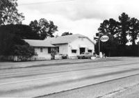
Esso gas station on site affected by the widening of U.S. Route 17. Presumably located in Mount Pleasant or vicinity. Surveyor notations on back of photo: "Dkt.: 10.597. Property owner: Mary B. McConnell. Tract: 79. Station 444+00 Lt. Date: Sept. 17, 1968." [See collection description for explanation of surveyor notations.]
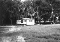
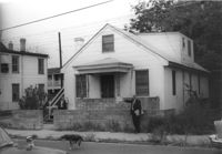
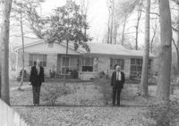
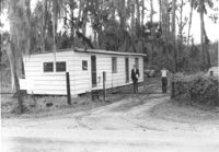
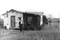
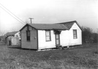
Mobile home on site affected by the widening of U.S. Route 17. Presumably located in southern Charleston County. Surveyor notations on back of photo: "Dkt.: 10.600. Property owner: John D. Postell, Jr. Tract: 15. Station: 623± Rt. Date: Sept. 18, 1968." [See collection description for explanation of surveyor notations.]
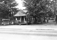
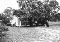
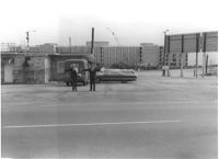
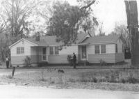
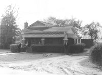
House and sweetgrass basket stand on site affected by the widening of U.S. Route 17. Presumably located in Mount Pleasant or vicinity. Surveyor notations on back of photo: "Dkt.: 10.597. Property owner: Linda Huger, Estate. Tract 84 & 85. Station: 448± Lt. Date: Sept. 17, 1968." [See collection description for explanation of surveyor notations.]
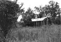
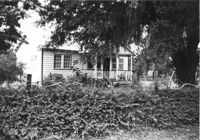
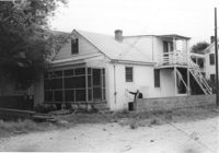
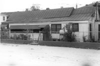
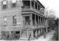
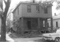
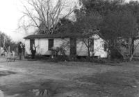
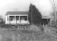
House in dilapidated condition and lot on site affected by the widening of U.S. Route 17. Presumably located in Mount Pleasant or vicinity. Surveyor notations on back of photo: "Dkt.: 10.597. Property owner: F. Gregorie, Estate. Tract: 93. Station: 458±10 Rt. Date: Sept. 17, 1968." [See collection description for explanation of surveyor notations.]
House (corner view, rear) on site affected by the widening of U.S. Route 17. Presumably located in Mount Pleasant or vicinity. Surveyor notations on back of photo: "Dkt.: 10.597. Property owner: Prince and Wilhelmina Gilliard. Tract: 92. Station: 457±10 Rt. Date: Sept. 17, 1968." [See collection description for explanation of surveyor notations.]
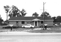
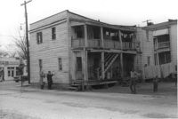
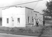
Farm Bureau building, on site affected by the widening of U.S. Route 17. Presumably located in southern Charleston County. Surveyor notations on back of photo: "Dkt.: 10.600. Property owner: Charleston County Farm Bureau. Tract: 2. Station: 507±30 Lt. Date: Sept. 18, 1968." [See collection description for explanation of surveyor notations.]
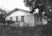
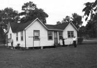
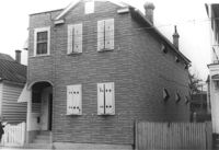
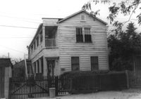
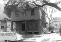
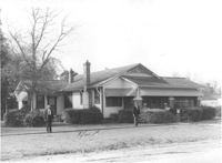
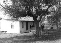
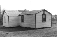
House on site affected by the widening of U.S. Route 17. Presumably located in Mount Pleasant or vicinity. Surveyor notations on back of photo: "Dkt.: 10.597. Property owner: John Gailliard. Tract: 102. Station: 466±40 Rt. Date: Sept. 17, 1968." [See collection description for explanation of surveyor notations.]
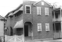
House on site affected by the widening of U.S. Route 17. Presumably located in Mount Pleasant or vicinity. Surveyor notations on back of photo: "Dkt.: 10.597. Property owner: Charles Dingle. Tract: 98. Station 462±50 Rt. Date: Sept. 17, 1968." [See collection description for explanation of surveyor notations.]
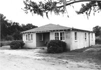
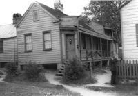
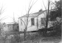
House on site affected by the widening of U.S. Route 17. Presumably located in Mount Pleasant or vicinity. Surveyor notations on back of photo: "Dkt.: 10.597. Property owner: F. Gregorie, Estate. Tract: 93. Station: 460± Rt. Date: Sept. 17, 1968." [See collection description for explanation of surveyor notations.]
House on site affected by the widening of U.S. Route 17. Presumably located in Mount Pleasant or vicinity. Surveyor notations on back of photo: "Dkt.: 10.597. Property owner: F. Gregorie, Estate. Tract: 93. Station: 460± Rt. Date: Sept. 17, 1968." [See collection description for explanation of surveyor notations.]
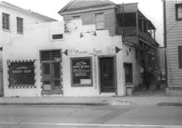
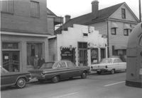
Building, on site affected by the construction of the Crosstown. Address: 209 Spring Street. Friendly Barber Shop and Spot Light Radio TV Service. Front facade has stepped parapet. Surveyor notations on back of photo: "Dkt.: 10.524. Property owner: Maybell Fields. Tract: 166. Station: 20+00 Rt. Spring Street. Date: Dec. 2, 1964." [See collection description for explanation of surveyor notations.]
Building, on site affected by the construction of the Crosstown. Address: 207 Spring Street. Sew-U-Save Shop. Surveyor notations on back of photo: "Dkt.: 10.524. Property owner: Olympia Papaeilidow. Tract: 167. Station: 20+35 Rt. Spring Street. Date: Dec. 2, 1964." [See collection description for explanation of surveyor notations.]
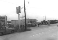
Shell gas station (rear view) on site affected by the construction of the Crosstown. Address: 233 Spring Street. Surveyor notations on back of photo: "Dkt.: 10.524. Property owner: Shell Oil Co. Tract: 155. Station: 9+00 Rt. Spring Street. Date: Dec. 2, 1965." [See collection description for explanation of surveyor notations.]
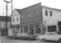
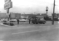
Hardee's, on site affected by the construction of the Crosstown. Address: 223 Spring Street. Surveyor notations on back of photo: "Dkt.: 10.524. Property owner: Sarah Chinnis Sanders. Tract: 157. Station: 14+60 Rt. Spring Street. Date: Dec. 2, 1964." [See collection description for explanation of surveyor notations.]
House on site affected by the construction of the Crosstown. Address: 114 Bogard Street. Surveyor notations on back of photo: "Dkt.: 10.524. Property owner: Francis Jenkins, et al. Tract: 64. Station: 75+70 CL Rt. Date: Oct. 14, 1964. In R/W - Bought." [See collection description for explanation of surveyor notations.]
House on site affected by the construction of the Crosstown. Address: 112 Bogard Street. Surveyor notations on back of photo: "Dkt.: 10.524. Property owner: Susan D. Butler, Est. Tract: 65. Station: 76+00 CL Rt. Date: Oct. 14, 1964. In R/W - Bought." [See collection description for explanation of surveyor notations.]
House on site affected by the construction of the Crosstown. Address: 116 Bogard Street. Surveyor notations on back of photo: "Dkt.: 10.524. Property owner: Arletha Powers. Tract: 63. Station: 75+40 CL. Date: Oct. 14, 1964. In R/W - Bought." [See collection description for explanation of surveyor notations.]
House on site affected by the construction of the Crosstown. Address: 116 Bogard Street. Surveyor notations on back of photo: "Dkt.: 10.524. Property owner: Arletha Powers. Tract: 63. Station: 75+40 CL. Date: Oct. 14, 1964. In R/W - Bought." [See collection description for explanation of surveyor notations.]
Building, on site affected by the construction of the Crosstown. Address: 209 Spring Street. Friendly Barber Shop and Spot Light Radio TV Service. Front facade has stepped parapet. Neighboring buildings on either side seen; Address 207 Spring Street and 211 Spring Street. Surveyor notations on back of photo: "Dkt.: 10.524. Property owner: Maybell Fields. Tract: 166. Station: 20+00 Rt. Spring Street. Date: Dec. 2, 1964." [See collection description for explanation of surveyor notations.]
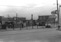
Side view of The Fork (restaurant) and lot on site affected by the construction of the Crosstown. Address: 223 Spring Street. Signs for the Castle Pinckney Motel and The Fork Restaurant at right. Presumably on Spring Street. Surveyor notations on back of photo: "Dkt.: 10.524. Property owner: The Fork Co. Inc. Tract: 156. Station: 13±00 Rt. Spring Street. Date: Dec. 2, 1964." [See collection description for explanation of surveyor notations.]
Side view of The Fork (restaurant) and lot on site affected by the construction of the Crosstown. Address: 223 Spring Street. Surveyor notations on back of photo: "Dkt.: 10.524. Property owner: The Fork Co. Inc. Tract: 156. Station: 13±00 Rt. Spring Street. Date: Dec. 2, 1964." [See collection description for explanation of surveyor notations.]
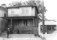
House (rear corner view) on site affected by the construction of the Crosstown. Address: 110 Bogard Street. Surveyor notations on back of photo: "Dkt.: 10.524. Property owner: Thomassina Elizabeth McCray. Tract: 72. Station: 76+60 Rt. Date: Oct. 14, 1964. In R/W - Bought." [See collection description for explanation of surveyor notations.]
House on site affected by the construction of the Crosstown. Address: 71 Kracke Street. Surveyor notations on back of photo: "Dkt.: 10.524. Property owner: William Henry Godfrey. Tract: 66. Station: 76+10 Lt. Date: Oct. 14, 1964. Portion in R/W to be removed." [See collection description for explanation of surveyor notations.]
House (rear view) and lot on site affected by the construction of the Crosstown. Address: 18-20 Wescott Street. Surveyor notations on back of photo: "Dkt.: 10.524. Property owner: Ralph E. Thornley, et al. Tract: 11. Station: 62+10 Lt. Date: Oct. 13, 1964." [See collection description for explanation of surveyor notations.]
Side view of house on site affected by the construction of the Crosstown. Address: 119 Bogard Street. Surveyor notations on back of photo: "Dkt.: 10.524. Property owner: Rebecca S. Cooper. Tract: 55. Station: 73+90 Rt. Date: Oct. 14, 1964. In R/W - Bought." [See collection description for explanation of surveyor notations.]
House on site affected by the construction of the Crosstown. Address: 110 Bogard Street. Surveyor notations on back of photo: "Dkt.: 10.524. Property owner: Thomassina Elizabeth McCray. Tract: 72. Station: 76+60 Rt. Date: Oct. 14, 1964. In R/W - Bought." [See collection description for explanation of surveyor notations.]
House on site affected by the construction of the Crosstown. Address: 190 Spring Street. Surveyor notations on back of photo: "Dkt.: 10.524. Property owner: E.H. Heidman, Est. Tract: 18. Station: 24± Lt. (Spring Street). Date: Oct. 13, 1964. Portion in R/W to be removed." [See collection description for explanation of surveyor notations.]
House on site affected by the construction of the Crosstown. Address: 190 Spring Street. Surveyor notations on back of photo: "Dkt.: 10.524. Property owner: E.H. Heidman, Est. Tract: 18. Station: 24± Lt. (Spring Street). Date: Oct. 13, 1964. Portion in R/W to be removed." [See collection description for explanation of surveyor notations.]
House on site affected by the construction of the Crosstown. Address: 22 Wescott Street. Surveyor notations on back of photo: "Dkt.: 10.524. Property owner: Ida J. Gantt. Tract: 10. Station: 61+20 Lt. Date: Oct. 13, 1964." [See collection description for explanation of surveyor notations.]
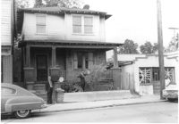
House (rear and side view) on site affected by the construction of the Crosstown. Address: 215 Spring Street. Corner of Spring Street and Vaughan Street. Paint and hardware store across the street. Surveyor notations on back of photo: "Dkt.: 10.524. Property owner: Ruby E. Jacobs. Tract: 163. Station: 18+85 Rt. Spring Street. Date: Dec. 2, 1964. Partially In R/W - Bought." [See collection description for explanation of surveyor notations.]
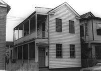
House (freedman's cottage) on site affected by the construction of the Crosstown. Address: 26 Kracke Street. Surveyor notations on back of photo: "Dkt.: 10.524. Property owner: Julia Brown. Tract: 68. Station: 77+55 Lt. Date: Oct. 14, 1964. Proximity." [See collection description for explanation of surveyor notations.]
House on site affected by the construction of the Crosstown. Address: 121 Sheppard Street. Surveyor notations on back of photo: "Dkt.: 10.524. Property owner: Erline B. Wertan. Tract: 138. Station: 17+05 Rt. N.B. lane. Date: Dec. 2, 1964. In R/W - Bought." [See collection description for explanation of surveyor notations.]
House on site affected by the construction of the Crosstown. Address: 121 Sheppard Street. Surveyor notations on back of photo: "Dkt.: 10.524. Property owner: Erline B. Wertan. Tract: 138. Station: 17+05 Rt. N.B. lane. Date: Dec. 2, 1964. In R/W - Bought." [See collection description for explanation of surveyor notations.]
House on site affected by the construction of the Crosstown. Address: 119 Sheppard Street. Surveyor notations on back of photo: "Dkt.: 10.524. Property owner: Scott M. Boyle. Tract: 139. Station: 17+45 Rt. N.B. lane. Date: Dec. 2, 1964. In R/W - Bought." [See collection description for explanation of surveyor notations.]
House on site affected by the construction of the Crosstown. Address: 119 Sheppard Street. Surveyor notations on back of photo: "Dkt.: 10.524. Property owner: Scott M. Boyle. Tract: 139. Station: 17+45 Rt. N.B. lane. Date: Dec. 2, 1964. In R/W - Bought." [See collection description for explanation of surveyor notations.]
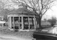
Gazebo, on site affected by the widening of Route 171 (Folly Road). Surveyor notations on back of photo: "Dkt.: 10.494. Property owner: Sophie Sabel, Est. Tract: 97. Station: 370+50 Lt. Date: Mar. 21, 1962. In R/W - Bought. [See collection description for explanation of surveyor notations.]
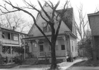
House on site affected by the widening of Route 171 (Folly Road). Surveyor notations on back of photo: "Dkt.: 10.494. Property owner: H.W. Halter, et al. Tract: 79. Station: 299+00 Rt. Date: Mar. 21, 1962. Proximity. [See collection description for explanation of surveyor notations.]
House on site affected by the widening of Route 171 (Folly Road). Surveyor notations on back of photo: "Dkt.: 10.494. Property owner: D.J. Byrd, et al. Tract: 73. Station: 280+60 Rt. Date: Mar. 21, 1962. Proximity. [See collection description for explanation of surveyor notations.]
Building, on site affected by the widening of Route 171 (Folly Road). Dave Richardson and Son General Contractor. Front facade has stepped parapet. Surveyor notations on back of photo: "Dkt.: 10.494. Property owner: Dave Richardson, et al. Tract: 93. Station: 314+40 Lt. Date: Mar. 21, 1962. To be cut off at R/W by SCHD [SC Highway Department?]. [See collection description for explanation of surveyor notations.]
House on site affected by the widening of Route 171 (Folly Road). Surveyor notations on back of photo: "Dkt.: 10.494. Property owner: Sophie Sabel, Est. Tract: 97. Station: 372+20 Lt. Date: Mar. 21, 1962. To be cut off at R/W by SCHD [SC Highway Dept.?]. [See collection description for explanation of surveyor notations.]
House on site affected by the widening of Route 171 (Folly Road). Surveyor notations on back of photo: "Dkt.: 10.494. Property owner: G.L. Brown, et al. Tract: 69. Station: 218+90 Rt. Date: Mar. 21, 1962. Proximity. [See collection description for explanation of surveyor notations.]
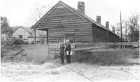
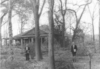
Building on site affected by the widening of Route 171 (Folly Road). Surveyor notations on back of photo: "Dkt.: 10.494. Property owner: John Harleston. Tract: 62. Station: 195+50 Rt. Date: Mar. 21, 1962. Moving item. [See collection description for explanation of surveyor notations.]
House on site affected by the widening of Route 171 (Folly Road). Surveyor notations on back of photo: "Dkt.: 10.494. Property owner: Sophie Sabel, Est. Tract: 97. Station: 372+20 Lt. Date: Mar. 21, 1962. To be cut off at R/W by SCHD [SC Highway Dept.?]. [See collection description for explanation of surveyor notations.]
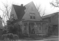
House named "Shady Grove," on site affected by the widening of Route 171 (Folly Road). Surveyor notations on back of photo: "Dkt.: 10.494. Property owner: Mrs. Martha A. Gibson. Tract: 72. Station: 279+80 Rt. Date: Mar. 21, 1962. Proximity. [See collection description for explanation of surveyor notations.]
House on site affected by the widening of Route 171 (Folly Road). Surveyor notations on back of photo: "Dkt.: 10.494. Property owner: H.W. Halter, et al. Tract: 79. Station: 299+00 Rt. Date: Mar. 21, 1962. Proximity. [See collection description for explanation of surveyor notations.]
House on site affected by the widening of Route 171 (Folly Road). Surveyor notations on back of photo: "Dkt.: 10.494. Property owner: John Richardson, Est. Tract: 94. Station: 338+70 Lt. Date: Mar. 21, 1962. To be cut off at R/W by SCHD [SC Highway Dept.?]. [See collection description for explanation of surveyor notations.]
House on site affected by the widening of Route 171 (Folly Road). Surveyor notations on back of photo: "Dkt.: 10.494. Property owner: John Richardson, Est. Tract: 94. Station: 335+50 Lt. Date: Mar. 21, 1962. In R/W - Bought. [See collection description for explanation of surveyor notations.]
House on site affected by the widening of Route 171 (Folly Road). Surveyor notations on back of photo: "Dkt.: 10.494. Property owner: John Richardson, Est. Tract: 94. Station: 335+50 Lt. Date: Mar. 21, 1962. In R/W - Bought. [See collection description for explanation of surveyor notations.]
House on site affected by the widening of Route 171 (Folly Road). Surveyor notations on back of photo: "Dkt.: 10.494. Property owner: John Richardson, Est. Tract: 94. Station: 336+60 Lt. Date: Mar. 21, 1962. In R/W - Bought. [See collection description for explanation of surveyor notations.]
House on site affected by the widening of Route 171 (Folly Road). Surveyor notations on back of photo: "Dkt.: 10.494. Property owner: John Richardson, Est. Tract: 94. Station: 336+60 Lt. Date: Mar. 21, 1962. In R/W - Bought. [See collection description for explanation of surveyor notations.]
Limit your search
SCDOT Photographs: Properties in the Right-of-Way✖[remove]2,061