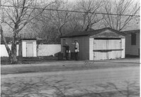
Garage and shed on site affected by the construction of Interstate 26 (I-26). Surveyor notations on back of photo: "Dkt.: 10.490. Property owner: Mostester Brown [Montester Brown?]. Tract: 87-C. Station: 5825+45 Rt. [Undated.] In R/W - Bought." [See collection description for explanation of surveyor notations.]
Garage and shed on site affected by the construction of Interstate 26 (I-26). Surveyor notations on back of photo: "Dkt.: 10.490. Property owner: Mostester Brown [Mostester Brown?]. Tract: 87-C. Station: 5825+45 Rt. Date: March 22, 1962. In R/W - Bought." [See collection description for explanation of surveyor notations.]
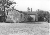
Garage and/or storage building on site affected by the construction of Interstate 26 (I-26).Address: 1317 King Street. Presumably part of the Rose Garden Tourist Court; see I-26 Photo 1467. Surveyor notations on back of photo: "Dkt.: 10.490. Property owner: The Long Corporation. Tract: 200. Station: 5889+45 Lt. Date: September 11, 1962. In R/W - Bought." [See collection description for explanation of surveyor notations.]
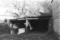
Garage and shed on site affected by the construction of the Crosstown. Address: 504 Rutledge Avenue. Surveyor notations on back of photo: "Dkt.: 10.524. Property owner: Florence Britton Jones. Tract: 114. Station: 87±00 Rt. Date: Dec. 1, 1964. In R/W - Bought." [See collection description for explanation of surveyor notations.]
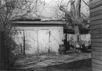
Garage and/or shed on site affected by the construction of the Crosstown. Address: 106 Sheppard Street. Surveyor notations on back of photo: "Dkt.: 10.524. Property owner: Annie H. Powers. Tract: 149. Station: 20+70 Lt. S.B. lane. Date: Dec. 2, 1964. In R/W - Bought." [See collection description for explanation of surveyor notations.]
Limit your search
SCDOT Photographs: Properties in the Right-of-Way✖[remove]5