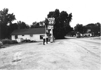
Phillips 66 gas station on site affected by the widening of U.S. Route 17. Gulf gas station in background. Presumably located in southern Charleston County. Surveyor notations on back of photo: "Dkt.: 10.600. Property owner: Nora Bishop Carmichael. Tract: 18. Station: 608±40 Lt. Date: Sept. 18, 1968." [See collection description for explanation of surveyor notations.]
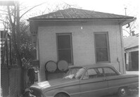
Building with gas pump (side view) on site affected by the construction of the Crosstown. Address: 134 Line Street. Surveyor notations on back of photo: "Dkt.: 10.524. Property owner: City of Charleston. Tract: 128. Station: 91+15 Rt. Date: Dec. 2, 1964. Partially in R/W." [See collection description for explanation of surveyor notations.]
Building with gas pump on site affected by the construction of the Crosstown. Address: 134 Line Street. Surveyor notations on back of photo: "Dkt.: 10.524. Property owner: City of Charleston. Tract: 128. Station: 91+15 Rt. Date: Dec. 2, 1964. Partially in R/W." [See collection description for explanation of surveyor notations.]
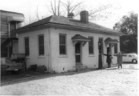
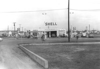
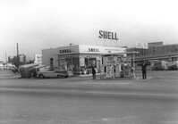
Shell gas station, on site affected by the construction of the Crosstown. Address: 233 Spring Street. View of street corner. Surveyor notations on back of photo: "Dkt.: 10.524. Property owner: Shell Oil Co. Tract: 155. Station: 9+00 Rt. Spring Street. Date: Dec. 2, 1965. Panoramic view." [See collection description for explanation of surveyor notations.]
Shell gas station, on site affected by the construction of the Crosstown. Address: 233 Spring Street. Surveyor notations on back of photo: "Dkt.: 10.524. Property owner: Shell Oil Co. Tract: 155. Station: 9+20 Rt. Spring Street. Date: Dec. 2, 1965." [See collection description for explanation of surveyor notations.]
Texaco gas station on site affected by the widening of U.S. Route 17. Presumably located in southern Charleston County. Surveyor notations on back of photo: "Dkt.: 10.600. Property owner: Harold Dukes. Tract: 16-B. Station: 628± Lt. Date: Sept. 18, 1968." [See collection description for explanation of surveyor notations.]
Gas station on site affected by the widening of U.S. Route 17. Presumably located in Mount Pleasant or vicinity. Surveyor notations on back of photo: "Dkt.: 10.597. Property owner: Charles Dingle. Tract: 98. Station 461±50 Rt. Date: Sept. 17, 1968." [See collection description for explanation of surveyor notations.]
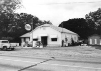
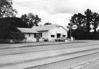
Gulf gas station and County Store on site affected by the widening of U.S. Route 17. Presumably located in Mount Pleasant or vicinity. Surveyor notations on back of photo: "Dkt.: 10.597. Property owner: Mrs. Catherine Owens, et al. Tract: 9. Station: 254+00 Rt. looking north. Date: Sept. 17, 1968." [See collection description for explanation of surveyor notations.]
Esso gas station on site affected by the widening of U.S. Route 17. Presumably located in Mount Pleasant or vicinity. Surveyor notations on back of photo: "Dkt.: 10.597. Property owner: Mary B. McConnell. Tract: 79. Station 444+00 Lt. Date: Sept. 17, 1968." [See collection description for explanation of surveyor notations.]
Esso gas station on site affected by the widening of U.S. Route 17. Presumably located in Mount Pleasant or vicinity. Surveyor notations on back of photo: "Dkt.: 10.597. Property owner: Mary B. McConnell. Tract: 79. Station 444+00 Lt. Date: Sept. 17, 1968." [See collection description for explanation of surveyor notations.]
Limit your search
SCDOT Photographs: Properties in the Right-of-Way✖[remove]52