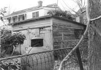
Sheds in backyard of house, on site affected by the construction of Interstate 26 (I-26). Address: 96 Sheppard Street. Surveyor notations on back of photo: "Dkt.: 10.517. Property owner: Celia McFadden. Tract: 102. 23+10 Rt. Southbound Lane Route 17. Date: March 5, 1963. In R/W - Bought." [See collection description for explanation of surveyor notations.]
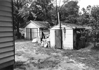
Sheds behind house on site affected by the widening of U.S. Route 17. Presumably located in Mount Pleasant or vicinity. Surveyor notations on back of photo: "Dkt.: 10.597. Property owner: Julia B. Simmons. Tract: 54. Station: 301±30 Lt. Date: Sept. 17, 1968." [See collection description for explanation of surveyor notations.]
Limit your search
SCDOT Photographs: Properties in the Right-of-Way✖[remove]2