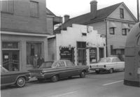
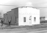
Building, on site affected by the construction of the Crosstown. Address: 207 Spring Street. Sew-U-Save Shop. Surveyor notations on back of photo: "Dkt.: 10.524. Property owner: Olympia Papaeilidow. Tract: 167. Station: 20+35 Rt. Spring Street. Date: Dec. 2, 1964." [See collection description for explanation of surveyor notations.]
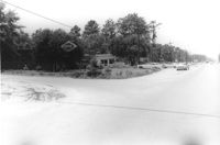
Shell gas station (rear view) on site affected by the construction of the Crosstown. Address: 233 Spring Street. Surveyor notations on back of photo: "Dkt.: 10.524. Property owner: Shell Oil Co. Tract: 155. Station: 9+00 Rt. Spring Street. Date: Dec. 2, 1965." [See collection description for explanation of surveyor notations.]
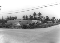
Hardee's, on site affected by the construction of the Crosstown. Address: 223 Spring Street. Surveyor notations on back of photo: "Dkt.: 10.524. Property owner: Sarah Chinnis Sanders. Tract: 157. Station: 14+60 Rt. Spring Street. Date: Dec. 2, 1964." [See collection description for explanation of surveyor notations.]
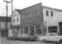
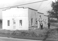
Building, on site affected by the construction of the Crosstown. Address: 209 Spring Street. Friendly Barber Shop and Spot Light Radio TV Service. Front facade has stepped parapet. Neighboring buildings on either side seen; Address 207 Spring Street and 211 Spring Street. Surveyor notations on back of photo: "Dkt.: 10.524. Property owner: Maybell Fields. Tract: 166. Station: 20+00 Rt. Spring Street. Date: Dec. 2, 1964." [See collection description for explanation of surveyor notations.]
Building, on site affected by the widening of Route 171 (Folly Road). Dave Richardson and Son General Contractor. Front facade has stepped parapet. Surveyor notations on back of photo: "Dkt.: 10.494. Property owner: Dave Richardson, et al. Tract: 93. Station: 314+40 Lt. Date: Mar. 21, 1962. To be cut off at R/W by SCHD [SC Highway Department?]. [See collection description for explanation of surveyor notations.]
H.W. Halter Cheese Butter Oleo Poultry Eggs [company], on site affected by the widening of Route 171 (Folly Road). Surveyor notations on back of photo: "Dkt.: 10.494. Property owner: H.W. Halter, et al. Tract: 78. Station: 209+20 Rt. Date: Mar. 21, 1962. Proximity. Loss of parking space. [See collection description for explanation of surveyor notations.]
Building, on site affected by the widening of Route 171 (Folly Road). Dave Richardson and Son General Contractor. Front facade has stepped parapet. Surveyor notations on back of photo: "Dkt.: 10.494. Property owner: Dave Richardson, et al. Tract: 93. Station: 314+40 Lt. Date: Mar. 21, 1962. To be cut off at R/W by SCHD [SC Highway Department?]. [See collection description for explanation of surveyor notations.]
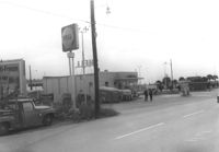
Esso Service Station: at intersection of Orange Grove Road and SC Highway 7 (Sam Rittenberg), on site affected by the widening of Routes 7 & 171. Surveyor notations on back of photo: "Dkt.: 10.551. Property owner: Humble Oil Co. Tract: 1. Station: 36±00 Rt. Date: Jul. 22, 1965. Taken from intersection of Orange Grove Rd. and Rte. 7 & 171. [See collection description for explanation of surveyor notations.]
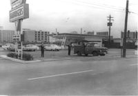
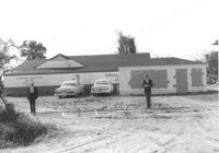
Ashley Lanes (bowling alley), on site affected by the widening of Routes 7 & 171. Surveyor notations on back of photo: "Dkt.: 10.551. Property owner: Ashley Lanes, Inc. Tract: 3. Station: 128±00 Lt. Date: Jul. 22, 1965. Looking SE from Ashley Hall Road and Rt. 7 intersection, at range poles on corners of ? area. [See collection description for explanation of surveyor notations.]
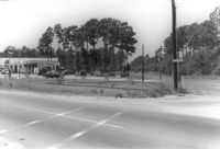
Orkin Pest Control - Termite Control, corner of Ashley Hall Road and Route 7 (Sam Rittenberg Boulevard), on site affected by the widening of Routes 7 & 171. Surveyor notations on back of photo: "Dkt.: 10.551. Property owner: Atlantic Investment & Development Co. Tract: 4. Station: 127±00 Rt. Date: Jul. 22, 1965. Range poles on corners of ? area - photographer standing in Rt. 7. [See collection description for explanation of surveyor notations.]
Limit your search
SCDOT Photographs: Properties in the Right-of-Way✖[remove]231