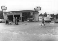
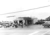
Crown gas station, on site affected by the widening of State Road 13 (Remount Road). Possibly the corner of North Rhett Avenue and Remount Road. Surveyor notations on back of photo: "Dkt.: 10.562. Property owner: Corco Realty Co. (Crown). Tract: 142. Date: Jul. 19, 1967." [See collection description for explanation of surveyor notations.]
Gulf gas station, on site affected by the widening of State Road 13 (Remount Road). Arrow Restaurant and Trucker's Billiard Academy across the street. Surveyor notations on back of photo: "Dkt.: 10.562. Property owner: E.R. Gassman. Tract: 1. Date: Jul. 12, 1967." [See collection description for explanation of surveyor notations.]
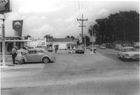
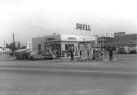
Shell gas station, on site affected by the widening of State Road 13 (Remount Road). Arrow Restaurant in background. Surveyor notations on back of photo: "Dkt.: 10.562. Property owner: Shell Oil Co., Inc. Tract: 2. Date: Jul. 12, 1967." [See collection description for explanation of surveyor notations.]
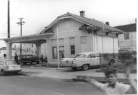
Corner view (rear) of building that may have previously been a gas station, on site affected by the construction of Interstate 26 (I-26). Address: 669 King Street. Surveyor notations on back of photo: "Dkt.: 10.517. Property owner: The Texas Co. Tract: 83. Station: 27+40 Rt. Northbound Lane Route 17. Date: March 5, 1963. In R/W - Bought." [See collection description for explanation of surveyor notations.]
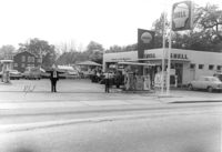
Shell gas station, on site affected by the construction of the Crosstown. Address: 233 Spring Street. Surveyor notations on back of photo: "Dkt.: 10.524. Property owner: Shell Oil Co. Tract: 155. Station: 9+20 Rt. Spring Street. Date: Dec. 2, 1965." [See collection description for explanation of surveyor notations.]
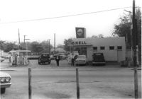
Shell gas station on site affected by the construction of Interstate 26 (I-26). Address: 1227 King Street. Surveyor notations on back of photo: "Dkt.: 10.503. Property owner: Shell Oil Co. Tract: 14-A. Station: 9+50 Rt. (Mt. Pleasant St.). Date: Apr. 20, 1965." [See collection description for explanation of surveyor notations.]
Shell gas station on site affected by the construction of Interstate 26 (I-26). Address: 1227 King Street. Surveyor notations on back of photo: "Dkt.: 10.503. Property owner: Shell Oil Co. Tract: 14-A. Station: 9+50 Rt. (Mt. Pleasant St.). Date: Apr. 20, 1965." [See collection description for explanation of surveyor notations.]
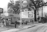
Shell gas station on site affected by the construction of Interstate 26 (I-26). Address: 1227 King Street. Surveyor notations on back of photo: "Dkt.: 10.503. Property owner: Shell Oil Co. Tract: 14-A. Station: 5893+80 Lt. Date: Feb. 19, 1963." [See collection description for explanation of surveyor notations.]
Gulf gas station, on site affected by the widening of Route 171 (Folly Road). Surveyor notations on back of photo: "Dkt.: 10.494. Property owner: Tremarco Corp. Tract: 46. Station: 178+90 Rt. Date: Mar. 21, 1962. Owner to move pumps. [See collection description for explanation of surveyor notations.]
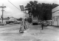
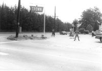
Crown gas station, on site affected by the widening of State Road 13 (Remount Road). View of street corner. Possibly the corner of North Rhett Avenue and Remount Road. Surveyor notations on back of photo: "Dkt.: 10.562. Property owner: Corco Realty Co. (Crown). Tract: 142. Date: Jul. 19, 1967." [See collection description for explanation of surveyor notations.]
Limit your search
SCDOT Photographs: Properties in the Right-of-Way✖[remove]52