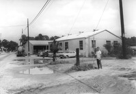
Building (industrial use?) on site affected by the widening of State Road 13 (Remount Road). Texaco and Gulf gas stations in background, across street). Surveyor notations on back of photo: "Dkt.: 10.562. Property owner: A.G. Boone Co. Tract: 15. Date: Jul. 12, 1967." [See collection description for explanation of surveyor notations.]
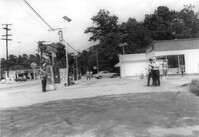
Opal Oil Co., on site affected by the widening of State Road 13 (Remount Road). Gulf gas Station: across the street. Surveyor notations on back of photo: "Dkt.: 10.562. Property owner: Ethel Barnes Morris. Tract: 22. Date: Jul. 12, 1967." [See collection description for explanation of surveyor notations.]
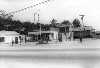
Opal Oil Co., on site affected by the widening of State Road 13 (Remount Road). Surveyor notations on back of photo: "Dkt.: 10.562. Property owner: Ethel Barnes Morris. Tract: 22. Date: Jul. 12, 1967." [See collection description for explanation of surveyor notations.]
Limit your search
SCDOT Photographs: Properties in the Right-of-Way✖[remove]3