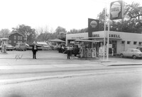
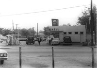
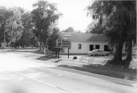
Shell gas station on site affected by the construction of Interstate 26 (I-26). Address: 1227 King Street. Surveyor notations on back of photo: "Dkt.: 10.503. Property owner: Shell Oil Co. Tract: 14-A. Station: 9+50 Rt. (Mt. Pleasant St.). Date: Apr. 20, 1965." [See collection description for explanation of surveyor notations.]
Shell gas station on site affected by the construction of Interstate 26 (I-26). Address: 1227 King Street. Surveyor notations on back of photo: "Dkt.: 10.503. Property owner: Shell Oil Co. Tract: 14-A. Station: 9+50 Rt. (Mt. Pleasant St.). Date: Apr. 20, 1965." [See collection description for explanation of surveyor notations.]
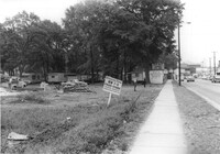
Sign "Opening soon - New 7-11 Food Store," on site affected by the widening of State Road 31 (Reynolds Avenue). Surveyor notations on back of photo: "Dkt.: 10.541. Property owner: Morris P. Sokol, et al. Tract: 1. Station: 2+80 Lt. Date: Apr. 20, 1965. Portion of office building in R/W." [See collection description for explanation of surveyor notations.]
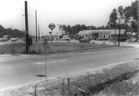
Esso Service Station: at intersection of Orange Grove Road and SC Highway 7 (Sam Rittenberg Boulevard), on site affected by the widening of Routes 7 & 171. Surveyor notations on back of photo: "Dkt.: 10.551. Property owner: Humble Oil Co. Tract: 1. Station: 36±00 Rt. Date: Jul. 22, 1965. West from east side Orange Grove Rd. of range poles on corners of ? area. [See collection description for explanation of surveyor notations.]
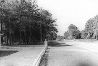
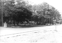
Lot in front of Mt. Pleasant Motel, on site affected by the widening of U.S. Route 17. Presumably located in Mount Pleasant or vicinity. Surveyor notations on back of photo: "Dkt.: 10.439. Property owner: George A. Kaiser, et al. Tract: 16. Station: 225+51 to 228+52 Lt. Date: Jul. 22, 1965. Taken from west side showing range poles on 50' R/W & brick columns on 33' R/W - Cond." [See collection description for explanation of surveyor notations.]
Mt. Pleasant Motel, on site affected by the widening of U.S. Route 17. Presumably located in Mount Pleasant or vicinity. Surveyor notations on back of photo: "Dkt.: 10.439. Property owner: George A. Kaiser, et al. Tract: 16. Station: 225+51 to 228+52 Lt. Date: Jul. 22, 1965. From across road showing brick columns on 33' R/W & range poles on 50' R/W - Cond." [See collection description for explanation of surveyor notations.]
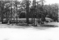
Mt. Pleasant Motel, on site affected by the widening of U.S. Route 17. Presumably located in Mount Pleasant or vicinity. Surveyor notations on back of photo: "Dkt.: 10.439. Property owner: George A. Kaiser, et al. Tract: 16. Station: 228+52 Lt. Date: Jul. 22, 1965. Taken from east side with brick columns on 33' R/W & range poles on 50' R/W - Cond." [See collection description for explanation of surveyor notations.]
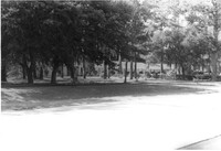
Mt. Pleasant Motel, on site affected by the widening of U.S. Route 17. Presumably located in Mount Pleasant or vicinity. Surveyor notations on back of photo: "Dkt.: 10.439. Property owner: George A. Kaiser, et al. Tract: 16. Station: 225+51 to 228+52 Lt. Date: Jul. 22, 1965. Looking from across road at range poles on 50' R/W." [See collection description for explanation of surveyor notations.]
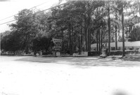
Lot and building (Basha's Garage) on site affected by the widening of U.S. Route 17. Posted signs for Basha's Garage. Presumably located in Mount Pleasant or vicinity. Surveyor notations on back of photo: "Dkt.: 10.439. Property owner: Ernest P. Basha, et al. Tract: 22-A. Station: 246+94 Lt. Date: Jul. 22, 1965. Proximity." [See collection description for explanation of surveyor notations.]
Mt. Pleasant Motel, on site affected by the widening of U.S. Route 17. Presumably located in Mount Pleasant or vicinity. Surveyor notations on back of photo: "Dkt.: 10.439. Property owner: George A. Kaiser, et al. Tract: 16. Station: 225+51 to 228+52 Lt. Date: Jul. 22, 1965. Range poles on 50' R/W. Face of brick columns on 33' R/W - Cond." [See collection description for explanation of surveyor notations.]
Limit your search
SCDOT Photographs: Properties in the Right-of-Way✖[remove]16