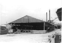
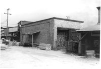
Storage structure for lumber and other structure (lumber processing?) on site affected by the construction of Interstate 26 (I-26). Address: Heriot Street. Presumably part of lumber yard. Surveyor notations on back of photo: "Dkt.: 10.490. Property owner: G.S. Carter & Son., Inc. Tract: 143. Station: 5878±. Date: August 29, 1962. To be cut off at R/W." [See collection description for explanation of surveyor notations.]
Storage structure for lumber on site affected by the construction of Interstate 26 (I-26). Address: Heriot Street. Presumably part of lumber yard. Surveyor notations on back of photo: "Dkt.: 10.490. Property owner: G.S. Carter & Son., Inc. Tract: 143. Station: 5878±. Date: August 29, 1962. To be cut off at R/W." [See collection description for explanation of surveyor notations.]
Storage structures for lumber on site affected by the construction of Interstate 26 (I-26). Address: Heriot Street. Presumably part of lumber yard. Surveyor notations on back of photo: "Dkt.: 10.490. Property owner: G.S. Carter & Son., Inc. Tract: 143. Station: 5878±. Date: August 29, 1962. To be cut off at R/W." [See collection description for explanation of surveyor notations.]
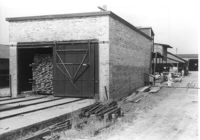
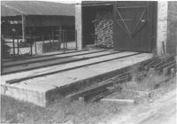
Storage structures for lumber on site affected by the construction of Interstate 26 (I-26). Address: Heriot Street. Presumably part of lumber yard. Surveyor notations on back of photo: "Dkt.: 10.490. Property owner: G.S. Carter & Son., Inc. Tract: 143. Station: 5878±. Date: August 29, 1962. In R/W - Bought." [See collection description for explanation of surveyor notations.]
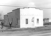
Building, on site affected by the widening of Route 171 (Folly Road). Dave Richardson and Son General Contractor. Front facade has stepped parapet. Surveyor notations on back of photo: "Dkt.: 10.494. Property owner: Dave Richardson, et al. Tract: 93. Station: 314+40 Lt. Date: Mar. 21, 1962. To be cut off at R/W by SCHD [SC Highway Department?]. [See collection description for explanation of surveyor notations.]
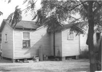
House (freedman's cottage) (rear view) on site affected by the construction of Interstate 26 (I-26). Surveyor notations on back of photo: "Dkt.: 10.490. Property owner: Janie Simmons. Tract: 41. Station: 5798+30 on CL Line 'G'. Date: September 12, 1962. In R/W - Bought." [See collection description for explanation of surveyor notations.]
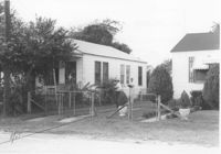
House (rear view) on site affected by the construction of Interstate 26 (I-26). [Building address number 1989.] Surveyor notations on back of photo: "Dkt.: 10.490. Property owner: John Hamilton. Tract: 33. Station: 5795+35 on CL Line 'A'. Date: September 11, 1962. In R/W - Bought." [See collection description for explanation of surveyor notations.]
View from street of houses on site affected by the construction of Interstate 26 (I-26). Addresses: 2126 Montford Avenue and its neighbor at 2124 Montford Avenue. Surveyor notations on back of photo: "Dkt.: 10.490. Property owner: Emory Hendrix, et al. Tract: 175. Station: 5884+80 Lt. Date: August 29, 1962. In R/W - Bought." [See collection description for explanation of surveyor notations.]
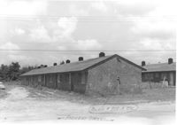
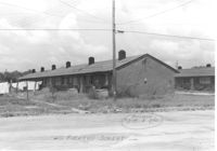
Multi-family housing on Pickens Street (308 Pickens Street), on site affected by the construction of Interstate 26 (I-26). Surveyor notations on back of photo: "Dkt.: 10.490. Property owner: Ashley Development Co. Tract: 1-A. Station: 5769+75 to 5771+25 Lt. Date: September 11, 1962. In R/W - Bought." [See collection description for explanation of surveyor notations.]
Multi-family housing on Pickens Street (310 Pickens Street), on site affected by the construction of Interstate 26 (I-26). Surveyor notations on back of photo: "Dkt.: 10.490. Property owner: Ashley Development Co. Tract: 1-A. Station: 5769+35 to 5771+00 on CL. Date: September 11, 1962. In R/W - Bought." [See collection description for explanation of surveyor notations.]
Limit your search
SCDOT Photographs: Properties in the Right-of-Way✖[remove]492