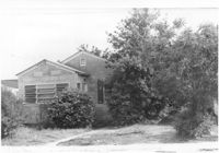
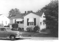
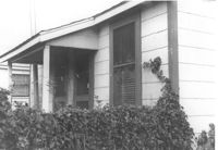
House on site affected by the construction of Interstate 26 (I-26). Address: 2117 Weaver Avenue. See also I-26 Photos 144-1445. View of house partially obscured by trees and bushes. See also I-26 Photo 1444. Surveyor notations on back of photo: "Dkt.: 10.490. Property owner: Mrs. Lucretia Nowak. Tract: 191. Station: 5888+85 Lt. Date: May 15, 1962. In R/W - Bought." [See collection description for explanation of surveyor notations.]
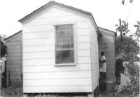
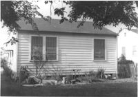
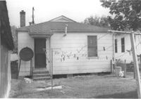
House (rear view) on site affected by the construction of Interstate 26 (I-26). Address: 2117 Weaver Avenue. See also I-26 Photos 1444-1445. Surveyor notations on back of photo: "Dkt.: 10.490. Property owner: Mrs. Lucretia Nowak. Tract: 191. Station: 5888+85 Lt. Date: May 15, 1962. In R/W - Bought." [See collection description for explanation of surveyor notations.]
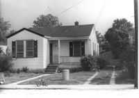
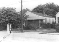
House on site affected by the construction of Interstate 26 (I-26). Address: 2123 Weaver Avenue. Surveyor notations on back of photo: "Dkt.: 10.490. Property owner: Henry Yaschik. Tract: 194. Station: 5888+10 Rt. Date: May 15, 1962. In R/W - Bought." [See collection description for explanation of surveyor notations.]
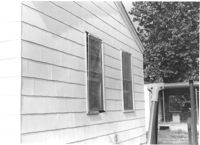
House (rear view) on site affected by the construction of Interstate 26 (I-26). Address: 2123 Weaver Avenue. Surveyor notations on back of photo: "Dkt.: 10.490. Property owner: Henry Yaschik. Tract: 194. Station: 5888+10 Rt. Date: May 15, 1962. In R/W - Bought." [See collection description for explanation of surveyor notations.]
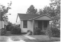
House on site affected by the construction of Interstate 26 (I-26). Address: 2125 Weaver Avenue. Surveyor notations on back of photo: "Dkt.: 10.490. Property owner: Rob't O. Davey [Robert O. Davey]. Tract: 195. Station: 80' Rt. Sta. 5887+90. Date: May 15, 1962. In R/W - Bought." [See collection description for explanation of surveyor notations.]
House (rear view) on site affected by the construction of Interstate 26 (I-26). Address: 2125 Weaver Avenue. Surveyor notations on back of photo: "Dkt.: 10.490. Property owner: Rob't O. Davey [Robert O. Davey]. Tract: 195. Station: 80' Rt. Sta. 5887+90. Date: May 15, 1962. In R/W - Bought." [See collection description for explanation of surveyor notations.]
House on site affected by the construction of Interstate 26 (I-26). Address: 2127 Weaver Avenue. View of house partially obscured by trees and bushes. Surveyor notations on back of photo: "Dkt.: 10.490. Property owner: John B. Priester, Jr. Tract: 196. Station: 115' Rt. Sta. 5887+70. Date: May 15, 1962. Proximity." [See collection description for explanation of surveyor notations.]
House on site affected by the construction of Interstate 26 (I-26). Address: 2129 Weaver Avenue. Surveyor notations on back of photo: "Dkt.: 10.490. Property owner: Lewis W. Infinger, Est. Tract: 197. Sta.: 110' Rt. Sta. 5889+25. Date: May 15, 1962. In R/W - Bought." [See collection description for explanation of surveyor notations.]
House (rear view) on site affected by the construction of Interstate 26 (I-26). Address: 2129 Weaver Avenue. Surveyor notations on back of photo: "Dkt.: 10.490. Property owner: Lewis W. Infinger, Est. Tract: 197. Sta.: 110' Rt. Sta. 5889+25. Date: May 15, 1962. In R/W - Bought." [See collection description for explanation of surveyor notations.]
House (rear view) on site affected by the construction of Interstate 26 (I-26). Address: 2124 Mt. Pleasant Street (possibly). Surveyor notations on back of photo: "Dkt.: 10.490. Property owner: Mrs. Barbara Hendricks. Tract: 197-A. Station: 130' Rt. Sta. 5889+00. Date: May 15, 1962. Proximity." [See collection description for explanation of surveyor notations.]
Limit your search
SCDOT Photographs: Properties in the Right-of-Way✖[remove]492