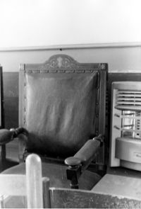
Old Bethel Methodist Church, 222 Calhoun Street. Interior View - Detail of Old Bishop's Chair. South (Rear) elevation. Charleston, S.C.;10" x 6.5" B/W photo. Box 7, Folder 2-1-43. One copy.
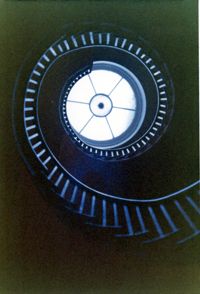
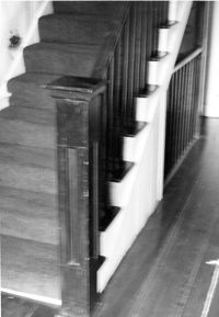
Lowndes Grove Plantation, 260 St. Margaret Street. Main House - Interior View. Detail of Flying Staircase, from ground, looking up. Charleston, S.C. NOTE: Print severely faded, color digitally restored.;5" x 3.5" Color photo. Box 8, Folder 2-1-148. One copy.
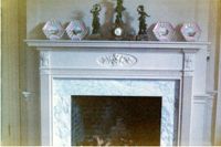
Lowndes Grove Plantation, 260 St. Margaret Street. Main House - Interior View. Detail of Mantle. Charleston, S.C. NOTE: Print severely faded, color digitally restored.;3.5" x 5" Color photo. Box 8, Folder 2-1-148. One copy.
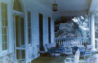
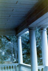
Lowndes Grove Plantation, 260 St. Margaret Street. Main House - View of 2nd Floor Porch, NW (Front and Side) elevation. Charleston, S.C. NOTE: Print severely faded, color digitally restored.;3.5" x 5" Color photo. Box 8, Folder 2-1-148. One copy.
Lowndes Grove Plantation, 260 St. Margaret Street. Main House - Detail View of 2nd Floor Porch, SW elevation. Charleston, S.C. NOTE: Print severely faded, color digitally restored.;5" x 3.5" Color photo. Box 8, Folder 2-1-148. One copy.
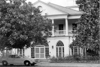
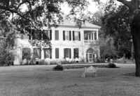
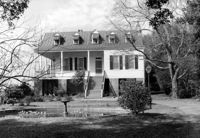
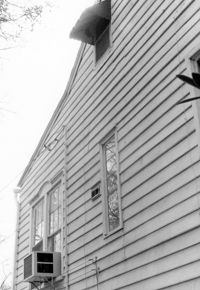
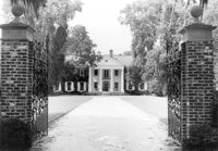
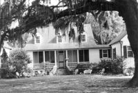
Lowndes Grove Plantation, 260 St. Margaret Street. Main House - View of North (Front) elevation. Charleston, S.C.;6.5" x 10" B/W photo. Box 8, Folder 2-1-148. One copy.
Lowndes Grove Plantation, 260 St. Margaret Street. Main House - View of NE (Front and Side) elevation. Charleston, S.C.;6.5" x 10" B/W photo. Box 8, Folder 2-1-148. One copy.
Lowndes Grove Plantation, 260 St. Margaret Street. Main House - View of NW (Front and Side) elevation. Charleston, S.C.;6.5" x 10" B/W photo. Box 8, Folder 2-1-148. One copy.
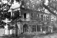
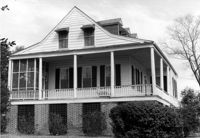
Lowndes Grove Plantation, 260 St. Margaret Street. Main House - View of East (Side) elevation. Charleston, S.C.;6.5" x 10" B/W photo. Box 8, Folder 2-1-148. One copy.
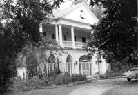
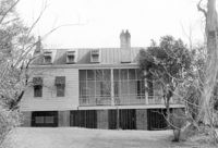
Lowndes Grove Plantation, 260 St. Margaret Street. Main House - View of SW (Side and Rear) elevation. Charleston, S.C.;6.5" x 10" B/W photo. Box 8, Folder 2-1-148. One copy.
Lowndes Grove Plantation, 260 St. Margaret Street. Kitchen House - View of North (Front) elevation. Charleston, S.C.;10" x 6.5" B/W photo. Box 8, Folder 2-1-148. One copy.
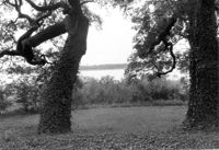
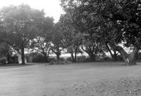
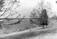
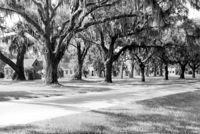
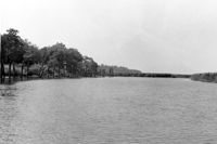
Lowndes Grove Plantation, 260 St. Margaret Street. View of Ashley River, West elevation. Charleston, S.C.;6.5" x 10" B/W photo. Box 8, Folder 2-1-148. One copy.
Lowndes Grove Plantation, 260 St. Margaret Street. View of Ashley River, West elevation. Charleston, S.C.;6.5" x 10" B/W photo. Box 8, Folder 2-1-148. One copy.
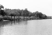
Lowndes Grove Plantation, 260 St. Margaret Street. View of Entry Gate and Ashley River, SW elevation. Charleston, S.C.;6.5" x 10" B/W photo. Box 8, Folder 2-1-148. One copy.
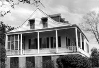
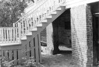
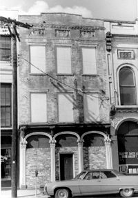
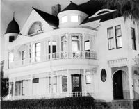
San Souci House, 206 San Souci Street. Detail View of Front Stairs. SW (Front and Side) elevation. Charleston, S.C.;6.5" x 10" B/W photo. Box 8, Folder 2-1-149. One copy.
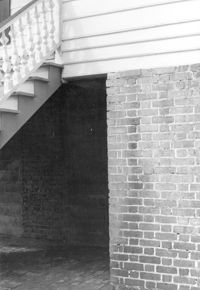
San Souci House, 206 San Souci Street. Detail View of Piers. SW (Front and Side) elevation. Charleston, S.C.;10" x 6.5" B/W photo. Box 8, Folder 2-1-149. One copy.
San Souci House, 206 San Souci Street. Interior View - 1st Floor. Detail of Newel Post. Charleston, S.C.;10" x 6.5" B/W photo. Box 8, Folder 2-1-149. One copy.
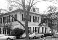
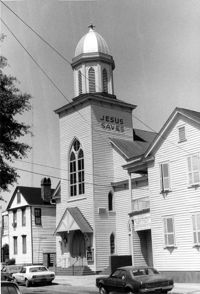
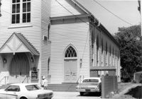
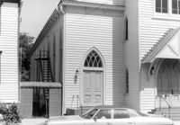
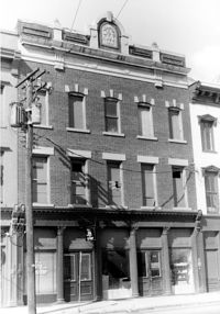
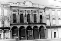
Central Baptist Church, 26 Radcliffe Street. View of SW (Front and Side) elevation. Charleston, S.C.;10" x 6.5" B/W photo. Box 9, Folder 2-1-156. One copy.
Central Baptist Church, 26 Radcliffe Street. View of SW (Side and Front) elevation. Charleston, S.C.;6.5" x 10" B/W photo. Box 9, Folder 2-1-156. One copy.
Central Baptist Church, 26 Radcliffe Street. View of SE (Side and Front) elevation. Charleston, S.C.;6.5" x 10" B/W photo. Box 9, Folder 2-1-156. One copy.
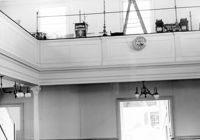
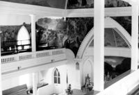
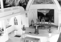
Central Baptist Church, 26 Radcliffe Street. Interior View - Upper Balcony and Chancel. SE (Front and Side) elevation. NOTE: Original print is out of focus. Charleston, S.C.;6.5" x 10" B/W photo. Box 9, Folder 2-1-156. One copy.
Central Baptist Church, 26 Radcliffe Street. Interior View - Altar and Pulpit. SE (Front and Side) elevation. NOTE: Original print is out of focus. Charleston, S.C.;6.5" x 10" B/W photo. Box 9, Folder 2-1-156. One copy.
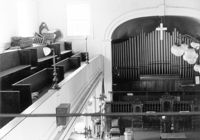
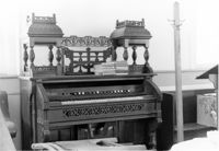
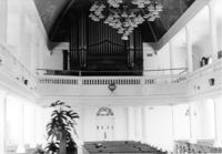
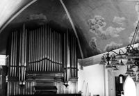
Central Baptist Church, 26 Radcliffe Street. Interior View - Organ and Side. NE (Rear and Side) elevation. Charleston, S.C.;6.5" x 10" B/W photo. Box 9, Folder 2-1-156. One copy.
Central Baptist Church, 26 Radcliffe Street. Interior View - Side and Rear. NE (Rear and Side) elevation. Charleston, S.C.;10" x 6.5" B/W photo. Box 9, Folder 2-1-156. One copy.
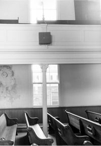
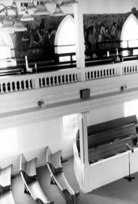
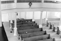
Central Baptist Church, 26 Radcliffe Street. Interior View - Balcony and Pews. NE (Rear and Side) elevation. Charleston, S.C.;10" x 6.5" B/W photo. Box 9, Folder 2-1-156. One copy.
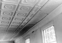
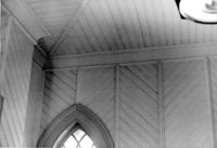
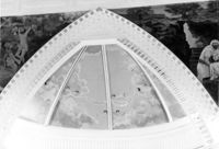
Central Baptist Church, 26 Radcliffe Street. Interior View - Detail of Vestibule Ceiling. NE (Rear and Side) elevation. Charleston, S.C.;6.5" x 10" B/W photo. Box 9, Folder 2-1-156. One copy.
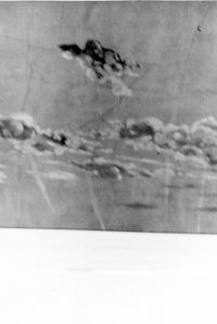
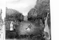
Central Baptist Church, 26 Radcliffe Street. Interior View - Detail of Balcony Mural. NE (Rear and Side) elevation. Charleston, S.C.;10" x 6.5" B/W photo. Box 9, Folder 2-1-156. One copy.
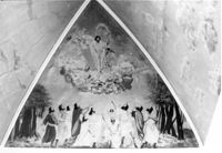
Central Baptist Church, 26 Radcliffe Street. Interior View - Detail of Balcony in Gable. South elevation. Charleston, S.C.;6.5" x 10" B/W photo. Box 9, Folder 2-1-156. One copy.
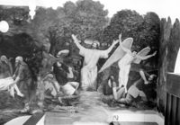
Central Baptist Church, 26 Radcliffe Street. Interior View - Detail of Mural in Apse. South elevation. Charleston, S.C.;6.5" x 10" B/W photo. Box 9, Folder 2-1-156. One copy.
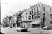
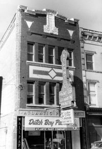
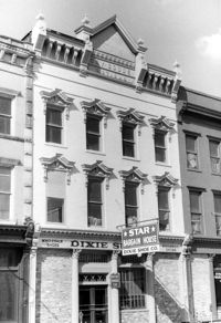
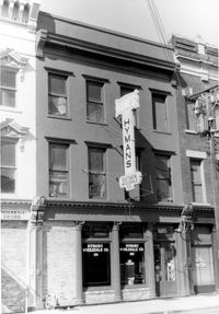
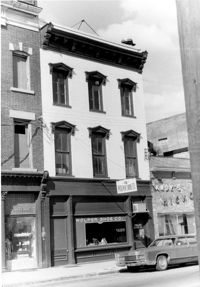
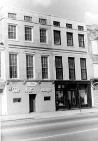
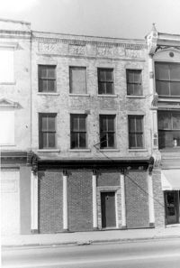
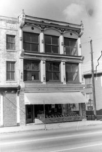
Cast Iron District, 207-235 Meeting Street - Detail of 207. View of NW (Front and Side) elevation. Charleston, S.C.;10" x 6.5" B/W photo. Box 9, Folder 2-1-159. Three copies.
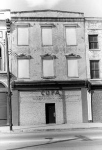
Cast Iron District, 207-235 Meeting Street - Detail of 209. View of NW (Front) elevation, looking North. Charleston, S.C.;10" x 6.5" B/W photo. Box 9, Folder 2-1-159. Three copies.
Cast Iron District, 207-235 Meeting Street - Detail of 211. View of NW (Front) elevation, looking North. Charleston, S.C.;10" x 6.5" B/W photo. Box 9, Folder 2-1-159. Three copies.
Cast Iron District, 207-235 Meeting Street - Detail of 213. View of NW (Front) elevation, looking North. Charleston, S.C.;10" x 6.5" B/W photo. Box 9, Folder 2-1-159. Three copies.
Cast Iron District, 207-235 Meeting Street - Detail of 215. View of NW (Front) elevation, looking North. Charleston, S.C.;10" x 6.5" B/W photo. Box 9, Folder 2-1-159. Three copies.
Cast Iron District, 207-235 Meeting Street - Detail of 217. View of NW (Front) elevation, looking North. Charleston, S.C.;10" x 6.5" B/W photo. Box 9, Folder 2-1-159. Three copies.
Cast Iron District, 207-235 Meeting Street - Detail of 223. View of NW (Front) elevation, looking North. Charleston, S.C.;10" x 6.5" B/W photo. Box 9, Folder 2-1-159. Three copies.
Cast Iron District, 207-235 Meeting Street - Detail of 227. View of NW (Front) elevation, looking North. Charleston, S.C.;10" x 6.5" B/W photo. Box 9, Folder 2-1-159. Three copies.
Cast Iron District, 207-235 Meeting Street - Detail of 229. View of NW (Front) elevation, looking North. Charleston, S.C.;6.5" x 10" B/W photo. Box 9, Folder 2-1-159. Three copies.
Cast Iron District, 207-235 Meeting Street - Detail of 231. View of NW (Front) elevation, looking North. Charleston, S.C.;10" x 6.5" B/W photo. Box 9, Folder 2-1-159. Three copies.
Cast Iron District, 207-235 Meeting Street - Detail of 233. View of NW (Front) elevation, looking North. Charleston, S.C.;10" x 6.5" B/W photo. Box 9, Folder 2-1-159. Three copies.
Cast Iron District, 207-235 Meeting Street - Detail of 235. View of NW (Front) elevation, looking North. Charleston, S.C.;10" x 6.5" B/W photo. Box 9, Folder 2-1-159. Three copies.
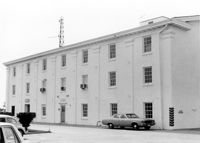
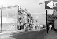
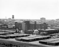
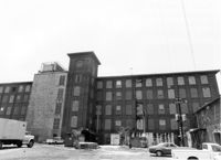
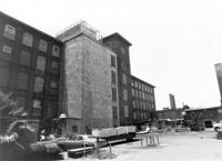
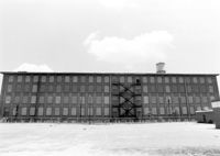
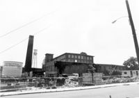
Cigar Factory, 701 East Bay Street. General View of NE (Front and Side) elevation. Charleston, S.C.;8" x 10" B/W photo. Box 9, Folder 2-1-221. One copy.
Cigar Factory, 701 East Bay Street. View of East (Front) elevation, looking North. Charleston, S.C.;7" x 10" B/W photo. Box 9, Folder 2-1-221. One copy.
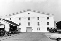
Cigar Factory, 701 East Bay Street. View of single story addition to main building, NW (Rear) elevation, looking South. Charleston, S.C.;7" x 10" B/W photo. Box 9, Folder 2-1-221. One copy.
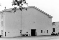
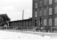
Cigar Factory, 701 East Bay Street. General View of Main Entrance (from Columbus Street), South (Side) elevation. Charleston, S.C.;7" x 10" B/W photo. Box 9, Folder 2-1-221. One copy.
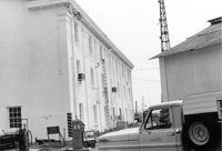
Cigar Factory, 701 East Bay Street. General View of North (Side) elevation (Blake Street in foreground). Charleston, S.C.;7" x 10" B/W photo. Box 9, Folder 2-1-221. One copy.
Boone Hall Plantation, Oak Avenue. Main House - View of North (Front) elevation. Mount Pleasant, S.C.;6.5" x 10" B/W photo. Box 10, Folder 2-2-5. One copy.
Boone Hall Plantation, Oak Avenue. Slave Cabins - General View of NW (Front and Side) elevation. Mount Pleasant, S.C.;6.5" x 10" B/W photo. Box 10, Folder 2-2-5. One copy.
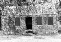
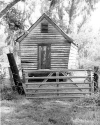
Boone Hall Plantation, Oak Avenue. Slave Cabin - View of North (Front) elevation. Mount Pleasant, S.C.;6.5" x 10" B/W photo. Box 10, Folder 2-2-5. One copy.
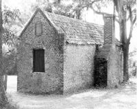
Boone Hall Plantation, Oak Avenue. Slave Cabin - View of SW (Side and Rear) elevation. Mount Pleasant, S.C.;8" x 10" B/W photo. Box 10, Folder 2-2-5. One copy.
Boone Hall Plantation, Oak Avenue. Gin House - View of NE (Front) elevation, looking East. Mount Pleasant, S.C.;6.5" x 10" B/W photo. Box 10, Folder 2-2-5. One copy.
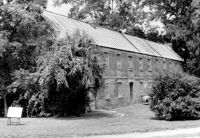
Boone Hall Plantation, Oak Avenue. Old Commissary - View of SW (Front and Side) elevation. Mount Pleasant, S.C.;6.5" x 10" B/W photo. Box 10, Folder 2-2-5. One copy.
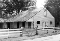
Boone Hall Plantation, Oak Avenue. Rat Proof Barn - View of South (Front) elevation. Mount Pleasant, S.C.;10" x 8" B/W photo. Box 10, Folder 2-2-5. One copy.
Boone Hall Plantation, Oak Avenue. Stable - View of SW (Front and Side) elevation. Mount Pleasant, S.C.;6.5" x 10" B/W photo. Box 10, Folder 2-2-5. One copy.
Boone Hall Plantation, Oak Avenue. Smoke House - View of NW (Front and Side) elevation. Mount Pleasant, S.C.;10" x 8" B/W photo. Box 10, Folder 2-2-5. One copy.
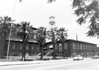
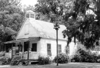
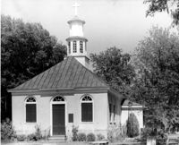
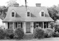
Christ Church (Christ Episcopal Church), 2304 U.S. Highway 17. View of North (Front) elevation. Mount Pleasant, S.C.;8" x 10" B/W photo. Box 10, Folder 2-2-6. One copy.
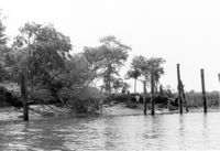
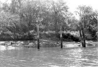
Paul Pritchard Shipyard Site, Address Restricted. General View, facing West. Mount Pleasant, S.C.;6.5" x 10" B/W photo. Box 10, Folder 2-2-8. One copy.
Paul Pritchard Shipyard Site, Address Restricted. General View, facing West. Mount Pleasant, S.C.;6.5" x 10" B/W photo. Box 10, Folder 2-2-8. One copy.
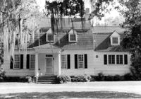
Oakland Plantation (Youghall Plantation), 1164 Porcher Bluff Road. Main House - View of South (Rear) elevation. Mount Pleasant, S.C.;6.5" x 10" B/W photo. Box 10, Folder 2-2-10. One copy.
Oakland Plantation (Youghall Plantation), 1164 Porcher Bluff Road. Main House - View of SW (Side and Rear) elevation. Mount Pleasant, S.C.;10" x 8" B/W photo. Box 10, Folder 2-2-10. One copy.
Oakland Plantation (Youghall Plantation), 1164 Porcher Bluff Road. Main House - View of North (Front) elevation. Mount Pleasant, S.C.;6.5" x 10" B/W photo. Box 10, Folder 2-2-10. One copy.
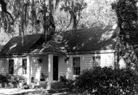
Oakland Plantation (Youghall Plantation), 1164 Porcher Bluff Road. Kitchen House - View of NE (Front) elevation. Mount Pleasant, S.C.;6.5" x 10" B/W photo. Box 10, Folder 2-2-10. One copy.
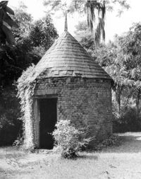
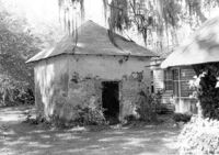
Oakland Plantation (Youghall Plantation), 1164 Porcher Bluff Road. Smoke House - View of NE (Front and Side) elevation. Mount Pleasant, S.C.;6.5" x 10" B/W photo. Box 10, Folder 2-2-10. One copy.
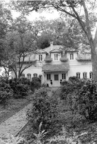
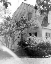
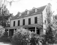
Bailey's House (Sandiford Holmes House), Point of Pines Road. View of NW (Front and Side) elevation. Edisto Island, S.C.;8" x 10" B/W photo. Box 10, Folder 2-3-1. One copy.
Limit your search
Photos from the Records of The Historic Preservation Planner, BCD-COG✖[remove]985