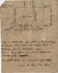
Plat includes 272 Acres with the Broad Road bisecting the property. Names associated with this plat are William Perry Perry, N. Bradwell, Archer Smith, the Ministry Lands and Joseph Perry. Notable geographic locations include St. George’s Parish, Bach Hill, Dorchester, and Broad Road.
Plat of 1000 acres is surrounded by vacant land. Names associated with this plat are John Stuart. Notable geographic locations include Berkeley County and St. Stephen's Parish.
Plat of 202 acres in St. James Goose Creek belonging to James Headright. Details include trees on the property line and the names of neighboring property owners. Names associated with this plat are James Headright.
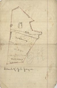
Unnamed plot of land that is divided into four parts, Santee swamp, ridge, Buck Swamp, and the section that includes a road and the house, no measurements or surrounding details. Names associated with this plat are G.S. Jayne.
Copy of two tracts of land A and B. A containing 1144 acres, and B, containing 580 located north of the Santee River and Duck Creek for Georgetown District. John Hutchinson, Chardon, Laroche, Foijsin, Gail Huger, Isaac Huger, Mark Hugin, Ford, Job. Rothmaklen, Jospeh Purcell and Charles Parker. Notable geographic locations include Mosquito Creek, Four Mile Creek, Belin Creek Duck Creek, Minim Creek, Santee River, Winyaw Bay, and Georgetown District.
296 acres of land conveyed to Alexander Walker to John Sumer and M. Weston executors of the last will and testament of Richard Downs (1705). Names associated with this plat include Richard Downs, Smith, Joseph Stanyarn, Coats, Alexander Walker, John Sumer, Plowden Weston, Roper and Chrisby [?]. Notable geographic locations include Broad Road to Jacksonborough and Stono.
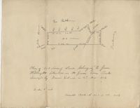
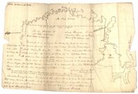
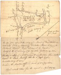
56 acre plot of land given to Radcliffe, the plot of land is bordering Cuckolds Creek, shows surrounding property owners, no land type detail or identification. Names associated with this plat are Thomas Radcliffe, Nathaniel Heyward, John Goddard and James Heyward. Notable geographic locations include Cuckolds Creek, Combahee River and St. Bartholomew's Parish.
179 acre plot of land given to Mr. Webster, shows the property lines and no land type detail. Names associated with this plat include Webster, Peters, Branford, and John James Haig. Notable geographic locations include the Pon Pon River.
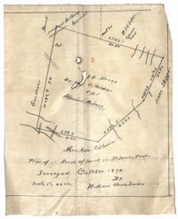
Plan of land in St. James Santee for Abraham Micheau. Names associated with this plat are Ann Colburn, Gardner, Anthony Germain, Buneli, B. Skipper, Isaac Skipper, Abraham Micheau, and William H. Simons.
Copy of plat of land being 903 belonging to Archer Smith in Georgetown District on the side of Pee Dee. Names associated with this plat are Archer Smith, Thomas Water, Abraham Livingston, J. Roshnakler, W. Glover, Preugh [?], Thomas Skrine [?], John J. Pringle, Alexander Roses and John Coates. Notable geographic locations include Pee Dee, Georgetown District, and Path to Black River from Pee Dee.
Limit your search
John McCrady Plats and Deeds Collection✖[remove]246