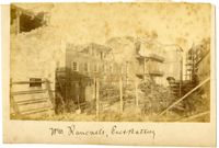
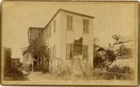
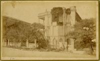
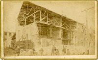
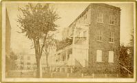
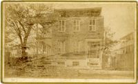
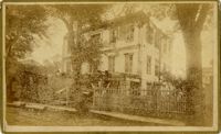
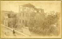
Charleston Earthquake scene. Possibly from Cook's Earthquake Views, no.63. William Ravenel, East Battery, rear. Written on front, at bottom: 'Wm Ravenel's, East Battery.'
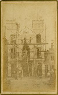
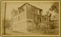
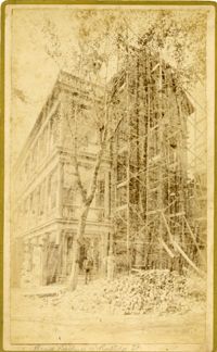
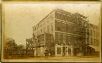
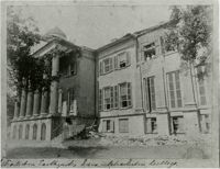
Caption: 'Cook's Earthquake Views of Charleston and Vicinity. Taken after the 31st of August, 1886. No.129, College as torn down.' Handwritten at bottom, front: 'Charleston Earthquake views - Charleston College. Both wings gone.'
Caption: 'Cook's Earthquake Views of Charleston and Vicinity. Taken after the 31st of August, 1886. No.70, E.B. Hume, Legare Street.' Charleston city directory for 1886 shows Errington B. Hume at 17 Legare Street.
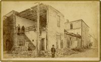
Written on reverse: 'House in which young Mr. Robson was killed. Two young ladies were buried in the ruins were rescued. Coming near Cannon.' Possibly from Cook's Earthquake Views, No.132, residence of J.N. Robson, from west. Written on front, at bottom: 'Charleston Earthquake view. Residence of Mr. J.N. Robson, whose eldest son was killed.' Charleston city directory for 1886 shows James N. Robson at 200 Coming Street.
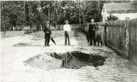
Caption: 'Cook's Earthquake Views of Charleston and Vicinity. Taken after the 31st of August, 1886. No.149, Robb's Lot.' Handwritten on reverse: ' Robb's Lot E. side [of] King bet[ween] Market & Horlbeck.'
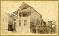
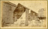
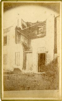
Charleston Earthquake scene. Labeled 'Old Hospital' in lower left corner, with 'Trapman Street' handwritten at bottom, front. Additional note on reverse: 'See Cook No.189 [from Series 2, which is captioned as 'Ruins of Colored hospital.']
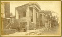
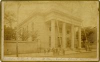
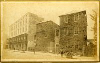
Caption: 'Cook's Earthquake Views of Charleston and Vicinity. Taken after the 31st of August, 1886. No.8, U.S. Court House.' Written on bottom, at front: 'Charleston Earthquake scene - United States Court House, Meeting Street.'
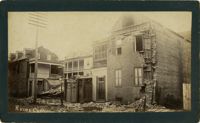
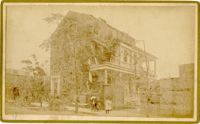
Caption: 'Cook's Earthquake Views of Charleston and Vicinity. Taken after the 31st of August, 1886. No.91, Brawley House, Legare Street.' Charleston city directory for 1886 shows Wm. H. Brawley at 9 Legare Street.
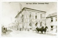
Caption: 'Cook's Earthquake Views of Charleston and Vicinity. Taken after the 31st of August, 1886. No.125, Scene near Atlantic Wharf.' Charleston city directory for 1886 lists Atlantic Wharf at the rear of the Post Office.
Caption: 'Cook's Earthquake Views of Charleston and Vicinity. Taken after the 31st of August, 1886. No.82, East Bay Street.' Sign for Jas [James] Ackermann at 114 East Bay is visible.
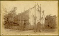
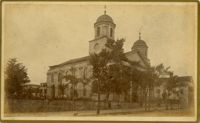
Caption: 'Cook's Earthquake Views of Charleston and Vicinity. Taken after the 31st of August, 1886. No.99, Rear of Scotch Church.' Handwritten at bottom, front: 'Charleston Earthquake scene - Rear of First Presbyterian Church.'
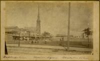
Caption: 'Cook's Earthquake Views of Charleston and Vicinity. Taken after the 31st of August, 1886. No.99, Rear of Scotch Church.' First (Scots) Presbyterian Church on Meeting Street.
Caption: 'Cook's Earthquake Views of Charleston and Vicinity. Series No.2. No.170, Buist residence, Rutledge Street.' Written on front, at bottom: Buist Residence, 43 Rutledge St.' Charleston city directory for 1886 shows listing for Samuel S. Buist at 43 Rutledge Avenue.
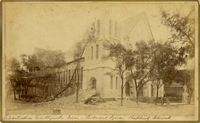
Caption: 'Cook's Earthquake Views of Charleston and Vicinity. Taken after the 31st of August, 1886. No.79, St. Mary's Church. [And handwritten] Hasell Street.'
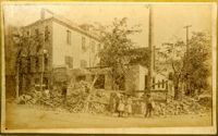
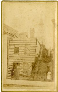
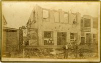
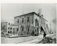
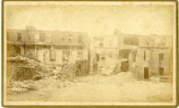
Caption: 'Cook's Earthquake Views of Charleston and Vicinity. Taken after the 31st of August, 1886. No.135, Corner State and Chalmers Streets.' Written on front, at bottom: 'Charleston Earthquake views - ruins cor[ner] Chalmers & State Str.'
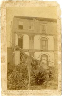
Caption: 'Cook's Earthquake Views of Charleston and Vicinity. Series No.2. No.187, residence of Mr. A. Lengnick.' Charleston city directory for 1886 shows Albert Lengnick at 11 Pitt Street.
Caption: 'Cook's Earthquake Views of Charleston and Vicinity. Series No.2. No.167, rear of residence of Geo. [George] W. Williams, Jr.' Charleston city directory for 1886 shows George W. Williams, Jr. at 2 Atlantic Street.
Caption: 'Cook's Earthquake Views of Charleston and Vicinity. Series No.2. No.182, Porch of Lazarus House.' Hassell Street. Charleston city directory for 1886 shows Mrs. B.D. Lazarus at 64 Hassell Street.
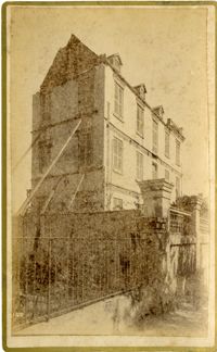
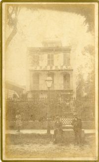
Caption: 'Cook's Earthquake Views of Charleston and Vicinity. Taken after the 31st of August, 1886. No.65, _____ Holmes, East Battery.' Written on front, at bottom: 'Charleston Earthquake scene - Holmes residence, East Battery.' Charleston city directory for 1886 shows Charles R. Holmes, Jr., at 19 East Battery.
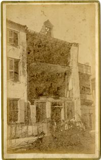
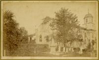
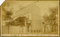
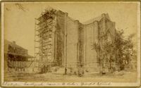
Charleston Earthquake scene. Possibly from Cook's Earthquake Views. Series No.2. No.169, College of Charleston, front [captioning missing, 'Cook No.169' handwritten on reverse].
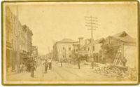
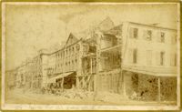
Caption: 'Cook's Earthquake Views of Charleston and Vicinity. Series No.2. No.154, East Bay, 60 days after the earthquake.' Written on front, at bottom: 'View on East Bay 60 days after the Earthquake.' Sign on building reads: 'Otto Tiedman & Sons.' Charleston city directory for 1886 shows business at 172-174 East Bay.
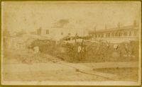
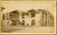
Caption: 'Cook's Earthquake Views of Charleston and Vicinity. Series No.2. No.159, Storehouses Adger's Wharf.' Charleston city directory for 1886 lists Adger's Wharf as opposite Tradd Street on East Bay.
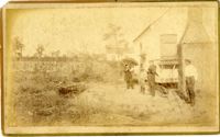
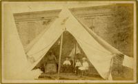
Caption: 'Cook's Earthquake Views of Charleston and Vicinity. Taken after the 31st of August, 1886. No.100, a family tent.' Image of an African-American nanny with three children.
Caption: 'Cook's Earthquake Views of Charleston and Vicinity. Taken after the 31st of August, 1886.' Possibly No.178, but corresponding captioning is missing. Handwritten on reverse: 'Formerly St. Luke's Episcopal now [New Tabernacle] Fourth Baptist Church, 22 Elizabeth Street.' Handwritten at bottom, front: 'Charleston Earthquake scene - St. Luke's Episcopal Church.'
Caption: 'Cook's Earthquake Views of Charleston and Vicinity. Taken after the 31st of August, 1886. [Marked as] No.16, First Presbyterian Church [and] No.99, Rear of Scotch Church.' Handwritten at bottom, front: 'Charleston Earthquake scene - First Presbyterian Church - side and rear view.'
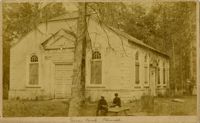
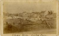
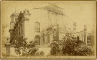
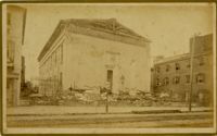
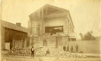
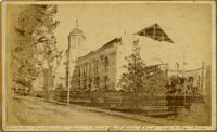
Caption: 'Cook's Earthquake Views of Charleston and Vicinity. Taken after the 31st of August, 1886. No.117, Citadel Square Baptist Church.' Also, handwritten at bottom, front: 'Charleston Earthquake scene - Citadel Square Baptist Church.'
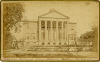
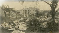
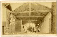
Caption: 'Cook's Earthquake Views of Charleston and Vicinity. Taken after the 31st of August, 1886. No.4, Roper Hospital.' Shows Roper Hospital when at Queen Street location.
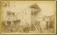
Caption: 'Cook's Earthquake Views of Charleston and Vicinity. Taken after the 31st of August, 1886. No.134, Dr. Frazer's, Tradd Street.' Charleston city directory for 1886 shows listing for Dr. Henry D. Fraser at 139 Tradd, with offices at 137 Tradd.
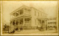
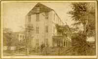
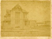
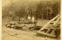
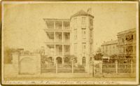
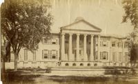
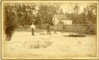
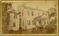
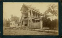
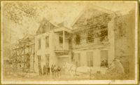
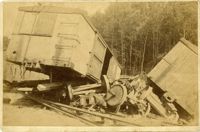
Caption: 'Charleston Earthquake. Photographs by Dr. E.P. Howland, taken on his visit to Charleston and the earthquake region of Ten Mile Hill and Summervile. Over 150 Photographs were taken. House of Mr. Ravenell [sic], President Northeastern R.R.'
Caption: 'Cook's Earthquake Views of Charleston and Vicinity. Taken after the 31st of August, 1886. No.78, Residence Wm. Johnson, Wentworth Street.' Charleston city directory for 1886 shows a William Johnson at 107 Wentworth Street.
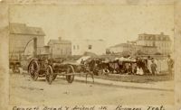
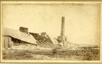
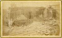
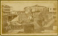
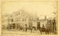
Charleston Earthquake scene. Written on front, at bottom: 'Commercial Cotton Press, East Bay.' Charleston city directory for 1886 lists Commercial Wharf and Cotton Press, Co. on East Bay Street and Longitude Lane.
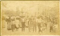
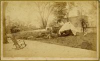
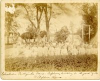
Caption: 'Charleston Earthquake. Photographs by Dr. E.P. Howland, taken on his visit to Charleston and the earthquake region of Ten Mile Hill and Summerville. Over 150 photographs were taken. Orphans and tents in which they lived.' Written on front, at bottom: 'Charleston Earthquake scene - orphans, standing the yard of the Orphan House.'
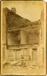
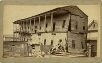
Caption: 'Cook's Earthquake Views of Charleston and Vicinity. Taken after the 31st of August, 1886. No.116, wreck in George Street.' Written on front, at bottom: 'Charleston Earthquake view - Ruins in George St.'
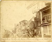
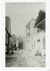
Caption: 'Cook's Earthquake Views of Charleston and Vicinity. Series No.2. No.181, Beresford Street.' This may be Beresford Alley which is also known as Clifford Street.
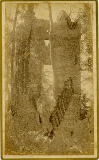
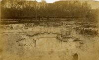
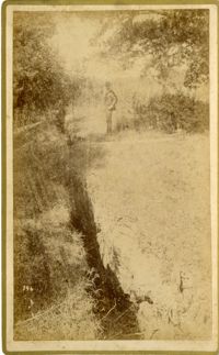
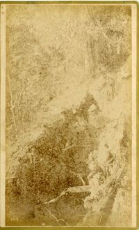
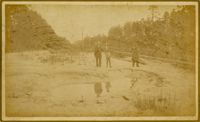
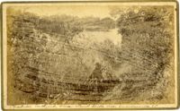
Caption: 'Cook's Earthquake Views of Charleston and Vicinity. Taken after the 31st of August, 1886. No.148, Landslide on the Ashley.' Handwritten at bottom, front: 'Charleston Earthquake view - Land slide near Summerville, S.C.'
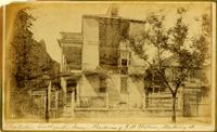
Caption: 'Cook's Earthquake Views of Charleston and Vicinity. Taken after the 31st of August, 1886. No.60, J.M. Wilson, Meeting St.' Charleston city directory for 1886 shows James M. Wilson at 39 Meeting Street.
Limit your search
Charleston Museum Earthquake Photographs✖[remove]203