Search
« Previous |
101 - 150 of 1,613
|
Next »
Search Results
Date:
1977-1983
Description:
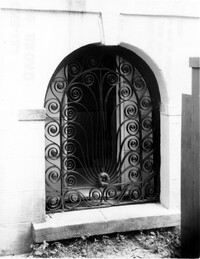
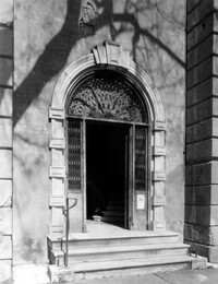
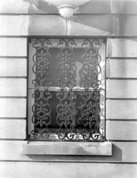
80 Broad Street, Charleston City Hall, ca. 1800. Detail View of Ground Floor arched window grille, North (Rear) elevation. 4" x 5" B/W photo.
Date:
1977-1983
Description:
71 Church Street, Col. Robert Brewton House, ca.1732. Interior View. 2nd Floor - East Room, North elevation. 4" x 5" B/W photo.
Date:
1977-1983
Description:
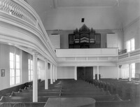
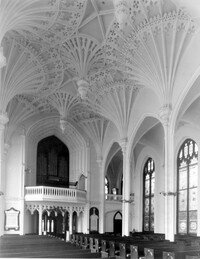
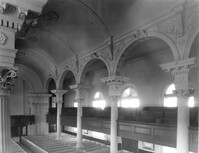
68 Spring Street, Karpeles Manuscript Library Museum (St. James United Methodist Church), ca. 1858. Interior View - Nave, looking South. 4" x 5" B/W photo.
Date:
1977-1983
Description:
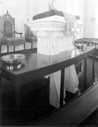
68 Spring Street, Karpeles Manuscript Library Museum (St. James United Methodist Church), ca. 1858. Interior View - Detail of pulpit. 4" x 5" B/W photo.
Date:
1977-1983
Description:
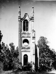
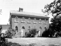
Georgetown County, Prince Frederick's Episcopal Church (Ruins), ca. 1859. View of South (Side) elevation. 4" x 5" B/W photo.
Date:
1977-1983
Description:
48 Elizabeth Street, Aiken-Rhett House, ca.1818. Main House - Detail View of entry to 2nd Floor Hall, SW (Front and Side) elevation. 4" x 5" B/W photo.
Date:
1977-1983
Description:
48 Elizabeth Street, Aiken-Rhett House, ca.1818. Main House - Interior View. 1st Floor - NW Room, entry from street, West elevation. 4" x 5" B/W photo.
Date:
1977-1983
Description:
48 Elizabeth Street, Aiken-Rhett House, ca.1818. Main House - Detail View of entry to 1st Floor, NW (Rear and Side) elevation. 4" x 5" B/W photo.
Date:
1977-1983
Description:
48 Elizabeth Street, Aiken-Rhett House, ca.1818. Main House - Detail View of entry, West (Side) elevation. 4" x 5" B/W photo.
Date:
1977-1983
Description:
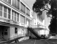
48 Elizabeth Street, Aiken-Rhett House, ca.1818. Main House - View of South (Front) elevation. 4" x 5" B/W photo.
Date:
1977-1983
Description:
456 King Street, William Aiken House, ca. 1811. Main House - Detail View of 1st Floor portico entry to Hall, South (Side) elevation. 4" x 5" B/W photo.
Date:
1977-1983
Description:
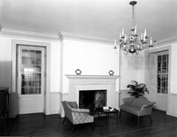
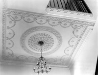
456 King Street, William Aiken House, ca. 1811. Main House - Interior View. 1st Floor - Detail of Hall ceiling medallion. 4" x 5" B/W photo.
Date:
1977-1983
Description:
Beaufort County, Auldbrass Plantation, ca. 1951. Kennels - View of NE elevation, from passage between Tack and Groom's Room. 4" x 5" B/W photo.
Date:
1977-1983
Description:
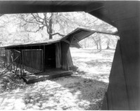
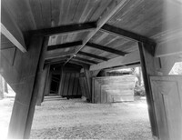
Beaufort County, Auldbrass Plantation, ca. 1951. Gate House - View of South elevation, through covered entry. 4" x 5" B/W photo.
Date:
1977-1983
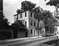
Description:
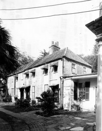
69 Barre Street, Gov. Thomas Bennett House, ca. 1822. Main House - View of SE (Front and Side) elevation. 4" x 5" B/W photo.
Date:
1977-1983
Description:
68 Broad Street, Daniel Ravenel House, ca. 1796. Dependency, View of SW (Side and Front) elevation. 4" x 5" B/W photo.
Date:
1977-1983
Description:
3 Atlantic Street, Benjamin Smith House, ca. 1820-1830. View of North (Front) elevation. 4" x 5" B/W photo.
Date:
1977-1983
Description:
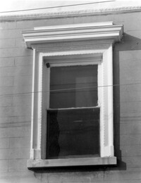
81 Rutledge Avenue, Glover-Sottile House, ca. 1826. Detail View of Ground Floor window, East (Front) elevation. 4" x 5" B/W photo.
Date:
1977-1983
Description:
81 Rutledge Avenue, Glover-Sottile House, ca. 1826. Detail View of 2nd Floor window, East (Front) elevation. 4" x 5" B/W photo.
Date:
1977-1983
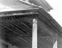
Description:
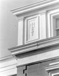
81 Rutledge Avenue, Glover-Sottile House, ca. 1826. Detail View of attic and cornice, East (Front) elevation. 4" x 5" B/W photo.
Date:
1977-1983
Description:
6 Archdale Street, Unitarian Church, ca. 1787. Interior View - East (Rear) elevation. 4" x 5" B/W photo.
Date:
1977-1983
Description:
93 Rutledge Avenue, Seabrook-Trenholm House, ca. 1819. View of South (Side) elevation, looking East. 4" x 5" B/W photo.
Date:
1977-1983
Description:
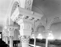
146 Church Street, St. Philip's Episcopal Church, ca. 1836. Interior View - Detail of balcony column capitals, NE (Rear and Side) elevation 4" x 5" B/W photo.
Date:
1977-1983
Description:
60 Montague Street, Gaillard-Bennett House, ca. 1800. Main House - Detail View of Ground Floor entry gate and 1st Floor stoop railing, South (Front) elevation. 4" x 5" B/W photo.
Date:
1977-1983
Description:
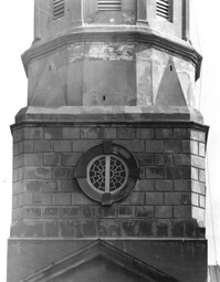
146 Church Street, St. Philip's Episcopal Church, ca. 1836. Detail View of tower base, South (Side) elevation. 4" x 5" B/W photo.
Date:
1977-1983
Description:
146 Church Street, St. Philip's Episcopal Church, ca. 1836. Interior View - balcony, NE (Rear and Side) elevation 4" x 5" B/W photo.
Date:
1977-1983
Description:
71 Church Street, Col. Robert Brewton House, ca.1732. Detail View of entry, South (Front) elevation 4" x 5" B/W photo.
Date:
1977-1983
Description:
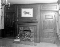
54 Queen Street, Thomas Elfe House, ca. 1760. Interior View - 1st Floor. North Room, East wall. 4" x 5" B/W photo.
Date:
1977-1983
Description:
18 Bull Street, William Blacklock House, ca. 1800. Carriage House - View of West (Side) elevation. 4" x 5" B/W photo.
Date:
1977-1983
Description:
60 Montague Street, Gaillard-Bennett House, ca. 1800. Main House - View of South (Front) elevation. 4" x 5" B/W photo.
Date:
1977-1983
Description:
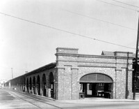
188 Meeting Street, Market Hall, ca. 1841. Shed #5 - View of East (Front) elevation. 4" x 5" B/W photo.
Date:
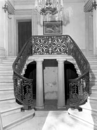
1977-1983
Description:
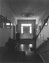
Georgetown County, Chicora Wood Plantation, ca. 1819. Main House - Interior View. 1st Floor - Hall, North elevation. 4" x 5" B/W photo.
Date:
1977-1983
Description:
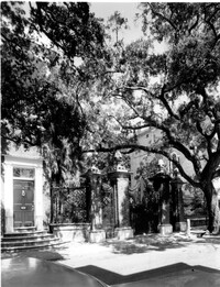
14 Legare Street, Simmons-Edwards House, ca. 1800. Main House - View of front entry and wood gates, West (Front) elevation. 4" x 5" B/W photo.
Date:
1977-1983
Description:
55 King Street, Grimke-Fraser Tenements, ca. 1762. Privy and Carriage House - View of SW (Side and Rear ) elevation. 4" x 5" B/W photo.
Date:
1977-1983
Description:
110 Broad Street, William Harvey House, ca. 1728.. Kitchen Building - Detail View of window, North (Rear) elevation. Top of window revealed after removal of hyphen. 4" x 5" B/W photo.
Date:
1977-1983
Description:
110 Broad Street, William Harvey House, ca. 1728. Kitchen Building - View of SE (Front and Side) elevation (after removal of hyphen). 4" x 5" B/W photo.
Date:
1977-1983
Description:
110 Broad Street, William Harvey House, ca. 1728. Main House - Interior View. SW Room, North elevation. 4" x 5" B/W photo.
Date:
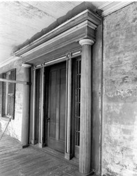
1977-1983
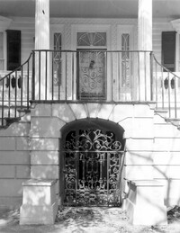
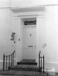
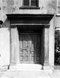
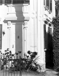
Description:
102 Broad Street, Dr. Henry Frost House, ca. 1844. Detail View of front entry, South (Front) elevation. 4" x 5" B/W photo.
Date:
1977-1983
Description:
110 Broad Street, William Harvey House, ca. 1728. Main House - View of SW (Front and Side) elevation. 4" x 5" B/W photo.
Date:
1977-1983
Description:
Berkley County, Lewisfield, ca. 1744. View of West (Rear) elevation. 4" x 5" B/W photo.
Date:
1977-1983
Description:
Berkley County, Lawson's Pond, ca. 1823. Detail View of corner portico column and cornice, SE (Side and Rear) elevation. 4" x 5" B/W photo.
Date:
1977-1983
Description:
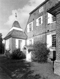
Berkley County, Mulberry Plantation, ca. 1714. Main House - View of West side and NW corner pavilion, looking North. 4" x 5" B/W photo.
Date:
1977-1983
Description:
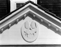
Berkley County, Mulberry Plantation, ca. 1714. Main House - Detail View of pediment ornament, South (Front) elevation. 4" x 5" B/W photo.
Date:
1977-1983
Description:
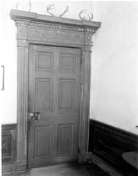
Berkley County, Lawson's Pond, ca. 1823. Interior View. 1st Floor - NW Room, North wall. Detail of door. 4" x 5" B/W photo.
Date:
1977-1983
Description:
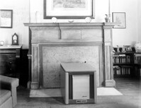
Berkley County, Lawson's Pond, ca. 1823. Interior View. 1st Floor - NW Room, South wall. Detail of mantle. 4" x 5" B/W photo.
Date:
1977-1983
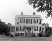
Description:
Charleston County, Oak Island Plantation, ca. 1830. View of North (Rear) elevation. 4" x 5" B/W photo.
Date:
1977-1983
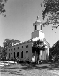
Description:
Charleston County, Edisto Island Presbyterian Church, ca. 1831. Church - View of SW (Front and Side) elevation. 4" x 5" B/W photo.
Date:
1977-1983
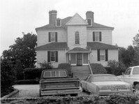
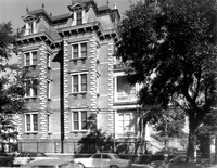
Description:
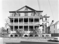
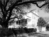
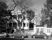
147 Wentworth Street, Francis Silas Rodgers Mansion, ca.1886. Main House - View of West (Side) elevation. 4" x 5" B/W photo.
Date:
1977-1983
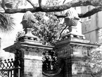
Description:
14 Legare Street, Simmons-Edwards House, ca. 1800. Main House - Detail View of West entry pier caps, West (Front) elevation. 4" x 5" B/W photo.
Date:
1977-1983
Description:
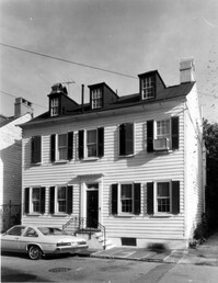
14 Lamboll Street, Patrick O'Donnell Tenement, ca. 1850. Detail View of entry, SE (Front and Side) elevation. 4" x 5" B/W photo.