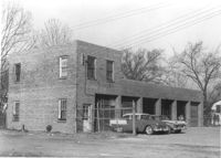
Commercial building with 6 bays (garage?) on site affected by the construction of Interstate 26 (I-26). Address: 739 Meeting Street. Surveyor notations on back of photo: "Dkt.: 10.503. Property owner: Alton M. Silver. Tract: 58. Station: 5908+15 Lt. Date: Feb. 20, 1963. In R/W - Bought." [See collection description for explanation of surveyor notations.]
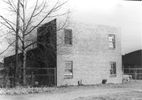
Side view of commercial building with 6 bays (garage?) on site affected by the construction of Interstate 26 (I-26). Address: 739 Meeting Street. Surveyor notations on back of photo: "Dkt.: 10.503. Property owner: Alton M. Silver. Tract: 58. Station: 5908+15 Lt. Date: Feb. 20, 1963. In R/W - Bought." [See collection description for explanation of surveyor notations.]
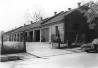
City Garage, on site affected by the construction of the Crosstown. Address: 134 Line Street. Surveyor notations on back of photo: "Dkt.: 10.524. Property owner: City of Charleston. Tract: 128. Station: 90+50 CL Rt. Date: Dec. 2, 1964. Partially in R/W." [See collection description for explanation of surveyor notations.]
City Garage, on site affected by the construction of the Crosstown. Address: 134 Line Street. Surveyor notations on back of photo: "Dkt.: 10.524. Property owner: City of Charleston. Tract: 128. Station: 90+50 CL Rt. Date: Dec. 2, 1964. Partially in R/W." [See collection description for explanation of surveyor notations.]
Right of way--South Carolina--Charleston County, Highway planning--South Carolina--Charleston County, Lost architecture--South Carolina--Charleston County, Garages--South Carolina--Charleston County✖[remove]4
Charleston County (S.C.)--Buildings, structures, etc.✖[remove]4